

OUR VISION
The world's finest educators supporting science, technology, engineering, and math (STEM) learning for pre-kindergarten to post-graduate students using real-world applications from satellites and satellite data.
OUR MISSION
To enhance the education environment to excite students about science, technology, engineering, and math through space-based technology -- satellites and satellite data.


Wilferd Peterson

Listen to the mustn’ts, child. Listen to the don’ts. Listen to the shouldn’ts, the impossibles, the won’ts. Listen to the never haves, then listen close to me…Anything can happen, child. Anything can be.
Shel Silverstein

TABLE OF CONTENTS
Click a RED link to view article
ASSOCIATION NEWS
PRESIDENT'S CORNER
JOHN'S JOURNEY
STEVE'S SPACE
SATELLITES
ACCESS
ANALYZE
APPLY
More Lessons
from the Sky

December 1, 2024
In this issue, the top story is again SmallSat Education Conference at Kennedy Space Center. John Moore includes a conference summary. SEA elected to support this conference in lieu of producing the Satellites & Education Conference.
The President's Corner continues to explore the growing crisis of space debris, Steve's Space adds a new guidance and control chapter to traveling in space, and John's Journey puts forth a call to action for transforming education.
2024 IN REVIEW offers NASA Kennedy's top 24 stories of the year and COP29 conclusions from NOAA.
The SATELLITES section brings us up to date on GOES-19 detection of large methane emissions and the monumental achievement of the Mars rover Perseverance climbing to the top of Jezero Crater's rim.
ACCESS includes the first imagery from GOES-19 SUVI instrument; new Skyfora StreamSondes for studying hurricanes; and the record-breaking surface ozone generated by wildfires.
ANALYZE offers NASA's investigation of the first aircraft accident on another world (Mars helicopter Ingenuity); how increased pollution puts the world behind in climate targets; and new NOAA research predicting increased hurricane seasons.
APPLY highlights JPSS observations making airline flights safer; NASA's Juno giving new insight to Jupiter's volcanic moon Io; and a fact checking list from NOAA debunking claims of weather modifications.
FOR TEACHERS lists and links more sites from NASA, NOAA, and SEA offering many easy to use educational resources, opportunities, and support for both students and teachers.
MORE LESSONS FROM THE SKY presents a recent update (June 2024) of How Landsat Works.
Enjoy!
--Editor

[ Back to Top ]

October 26-27, 2024
The 2024 SmallSat Education Conference was held in The Center for Space Education at Kennedy Space Center in Florida, October 26-27. The conference was focused on educational opportunities and curricula for community college, high school and middle school faculty and students.
The Satellite Educators Association has been a significant supporter of this extraordinary event for the last two years. Members of the SEA Executive Committee served on the conference planning committee as well.
At the SEA Annual Meeting in August, SEA members elected not to produce the Satellites & Education Conference in 2025 or 2026. Instead, the Association chose to sponsor the SmallSat Education Conference. The Satellite Educators Association has been a significant supporter of this event for the last two years. Members of the SEA Executive Committee also served on the conference planning committee.
SEA member John Moore, Executive Director of the Institute for Earth Observations in New Jersey, has been a regular attendee and presenter at the SmallSat Education Conference. You are invited to read his "John's Journey" article in this SEA Newsletter as it includes a capsule summary of this year's conference.

[ Back to Top ]


By Simon Cracknell, President, Satellite Educators Association
The topic of space junk, that I began writing about in the last newsletter was inspired by something I read about a Japanese idea to build satellites partially out of wood. Later I discovered that it had already been made by researchers at Kyoto University, and it was going to be released from the International Space Station (ISS). It resembled a cube sat I had seen a model of at a previous SEA conference years ago, but this had paneling from the magnolia tree and was named LignoSat, after the Latin word for wood "lignum." The lack of water or oxygen would prevent it rotting or swelling like it does in a terrestrial environment.
Recently, I was reminded of the "Spruce Goose," a Howard Hughes inspired flying boat made almost entirely of birch. It successfully made its maiden flight but never flew again. Remembering the "Spruce Goose" raises questions of limitations of wooden construction for spacecraft. What vulnerabilities exist for satellites made of similar materials even from the smallest, seemingly innocuous things moving in orbit?
It struck me that other strategies may need to be considered before this is becomes a more widespread application. Some strategies are not new ideas. For example, an "end of life" protocol, a mechanism to deorbit safely after their mission with controlled re-entry into Earth’s atmosphere where they burn up. SpaceX is pioneering another strategy, reusable launch systems which reduce the number of discarded rocket stages in orbit.
Strategies that are not yet widespread use and indeed not even tested yet include active debris removal that involve nets and harpoons which will collect debris and take them out of near-Earth orbit. Robotic arms are about to be tested by the European Space Agency’s ClearSpace-1 mission. These can attach to defunct satellites and guide them to a safe re-entry trajectory, rendering them harmless as they are removed from orbit and burn-up in the atmosphere.
Being able to provide much more data on what debris is currently in orbit will allow their impact to be mitigated so better tracking and monitoring is crucial. More advance radar and telescopes may be able to track debris. This inevitably will come with a higher price tag and as such, it may be difficult to make this happen. The tracking of large celestial bodies is a vital endeavor but we also know that a tiny part of the US federal budget goes to NASA [0.48%] and out of that, they manage CNEOS [Center for Near Earth Object Studies] so time will tell. >
The practices that we are engaging in on Earth, like developing a circular economy, can be done in space. Recycling defunct satellites could become a booming business and could see them either repaired or the materials recycled. An element of accountability could be introduced, much like modern car manufacturers are required to engage in sustainable practices during assembly. For example, commercial businesses that launch such orbiting equipment may be responsible for what happens to it after its operational life span ends. This could prompt the sector to work on new ideas to further enhance sustainability in space.
One thing is certain, the efforts to mitigate the risks of debris in space will not be focused on one aspect only. It will need a ratified update to the 1967 Outer Space Treaty, as well as have the most innovative thinkers in the sector on board to make it more sustainable while still profitable -- further encouraging more investment and enhancing technological development.

[ Back to Top ]


By John D. Moore, Executive Director, Institute for Earth Observations at Palmyra Cove, New Jersey
As I reflect on my journey in recent months, three separate but related concerns -- the SmallSat Education Conference, the GLOBE Program, and our national science agenda -- lead me to call for action in transforming learning.
The 2024 SmallSat Education Conference, held at NASA’s Kennedy Space Center in October, was a landmark event, celebrating the growing role of satellite technology in education. With over 500 attendees from 20 countries and 60 student-led projects, the conference highlighted the increasing global interest in satellite-based learning. One of the key achievements of the event was the diverse participation from across educational levels, from middle schools to universities, reinforcing the integration of space-related studies into curricula. Attendees were also introduced to cutting-edge satellite technologies through exhibitors and vendors, providing insights into the latest innovations in the field.
One of the most inspiring moments of the conference was the live viewing of a SpaceX Falcon 9 rocket launch. It symbolized the potential of satellites to connect students and classrooms to the forefront of space exploration. As the conference looks to expand next year by incorporating remote sensing applications into its programming, the evolution of this event signals the growing importance of satellite technology in K-12 education.
Given the rapid growth and increasing influence of the SmallSat Education Conference, it is only logical that the Satellite Educators Association (SEA) deepen its partnership with the event. In just three years, the conference has become a critical platform for showcasing innovations in satellite education. SEA’s role in this growing space would allow for stronger support, mentorship, and professional development for both educators and students.
By formalizing a closer relationship, SEA can provide the expertise needed to integrate satellite technology more deeply into curricula and classroom practices. With an expanding reach that now includes remote sensing, this partnership offers a natural pathway to ensure the sustainability and growth of the conference, as well as further promote satellite education as an essential tool in STEM learning.
Satellites are no longer exclusive tools for scientists — they are powerful educational platforms that can help students engage with real-world challenges. Programs such as CubeSats in Peru and the A3Sat CubeSat Emulator have already demonstrated how K-12 students can actively design, build, and launch satellite prototypes, providing them with hands-on experience and critical STEM skills.
With the integration of remote sensing into future SmallSat Education Conferences, students will have even greater opportunities to analyze real-time satellite data, which is vital for understanding issues like climate change, disaster management, and global health. Remote sensing technologies allow students to make connections between data collected from satellites and the problems they see in their communities and the world around them.

We celebrate the GLOBE Program’s 30th Anniversary in April 2025. The NASA GLOBE Program has been a valuable tool for engaging students in Earth observations and environmental science. GLOBE has successfully provided students internationally with opportunities to make ground-based observations, share data, and conduct student research. However, there are critically missed opportunities as it has not fully integrated the use of satellite data, and/or imagery into its framework.
Satellites provide a wealth of data that could enhance GLOBE’s impact, but this opportunity remains largely untapped in many classrooms. In 1995 we were introduced to LandSat imagery and data, with data sets of our schools. This was a very innovative step forward in the role of using satellite data in schools. While there are some opportunities for student participation with earth observing satellites, it has not been promoted as one of the key themes, odd since the program is funded through NASA. Students working on GLOBE projects could be learning to correlate their local observations with satellite data, deepening their understanding of global systems and reinforcing the interconnectedness of the Earth and space sciences. Unfortunately, this gap in satellite integration limits GLOBE’s potential to prepare students for the cutting-edge scientific methods used in modern Earth and space research, thus questioning the future contributions to student driven Earth Science.
To bridge this gap, NASA’s GLOBE Program could consider:
Integrating satellite data into the GLOBE Program would not only enrich student learning but also better align the program with the tools and technologies that are central to solving real-world problems.
This is a larger question. A possible reason for GLOBE’s lack of satellite integration into K-12 public education is while the U.S. invests heavily in space exploration, satellite technologies, and Earth observation systems—tools that are critical to addressing the nation’s scientific, environmental, and security challenges, these investments are not always reflected in K-12 science education. Why doesn’t science education mirror the nation’s scientific priorities?
Several reasons contribute to this gap:
As satellites continue to play a key role in national security, environmental monitoring, and scientific discovery, it is crucial that we bring these technologies into classrooms across the country. Students must have the tools to understand how satellites contribute to fields like climate science, disaster response, and national security.
To close the gap between the national science agenda and K-12 education, several steps should be taken:
By integrating satellite education more fully into K-12 classrooms, we can better prepare students to engage with the world’s most pressing scientific challenges.
The creation and rapid development of the U.S. Space Force highlights the critical importance of satellite technology for national security. Once questioned for its relevance as a military initiative that emphasizes the role of satellites, it has been made evident that satellites are playing a vital role in communication, surveillance, and defense—making them central to the country’s security infrastructure. As the Space Force expands, the need for skilled workers to maintain and advance these satellite systems grows. Our military is very serious about this, and it is not reflected in education.
By introducing satellite education at the K-12 level, we not only prepare students for careers in aerospace and defense but also support national security initiatives by ensuring a future workforce that is equipped to meet the challenges of a rapidly evolving space domain.
The 2024 SmallSat Education Conference was a clear reminder of the growing potential of satellite education to transform STEM learning. Strengthening the partnership between the Satellite Educators Association and the SmallSat Education Conference, along with aligning science education with the national science agenda, will help equip the next generation with the skills needed to lead in an interconnected, technology-driven world.
As satellites continue to shape science, industry, and national security, integrating them into the classroom should become a priority. This will not only inspire students but also empower them to become the next generation of leaders in space, science, and technology.
As we look to the future, the opportunities for students to engage with satellite technology and remote sensing have never been greater. With the rapid advancements in space exploration, the growing need for satellite expertise, and the expanding role of the U.S. Space Force, the demand for a new generation of skilled professionals in aerospace, Earth sciences, and technology is clear. By embracing satellite education in K-12 classrooms, we are not only equipping students with cutting-edge tools and knowledge, but we are also opening doors to exciting careers in space, security, and global research. The path forward is one of innovation, collaboration, and hands-on learning—where students can become the pioneers of tomorrow's space economy and scientific breakthroughs. The future is bright, and the sky is the limit for the students of today who will shape the world of tomorrow. Working with a growing student workforce at the Institute for Earth Observations, and providing them a place to expand their skills, we are excited about developing exceptional individuals that Investigate the Earth from Space.
Stay safe -- stay well!
For now, I'm John...and this is my Journey

[ Back to Top ]


By Steve Mills, Retired Systems Engineering Scientist; owner and Chief Engineer of Polymath Geo
In my last column I wrote about some common misconceptions about space travel. One point I made is that there is a big difference between getting into space and going into orbit. Getting into space requires large amounts of power, but orbit requires more than power—it also requires guidance and control. To understand guidance and control in space we need to consider Issac Newton’s three laws of motion plus his universal law of gravitation. Let me say up front that it is no easy task.
In 1543 Copernicus published his theory that all the planets orbited around the sun in circular orbits. In 1609 Kepler refined this, observing that these orbits were slightly elliptical, and that their velocities varied, following geometric rules, as shown below.
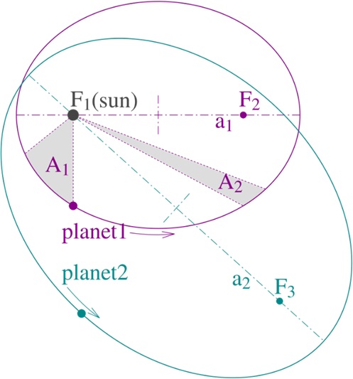
Though these pioneers of astronomy made meticulous geometric observations about planetary orbits, they could not explain why they should have this particular geometry. So, it was left to Newton to show that the geometry of planetary orbits observed by Kepler could be explained using mathematical laws. In doing so he had to invent a whole new branch of mathematics called differential calculus.

In 1687 Newton published his theories in Philosophiæ Naturalis Principia Mathematica (or Principia for short). Newton’s laws are intrinsically mathematical, and when I first learned these laws in high school, I failed to realize just how revolutionary that fact is. The Principia was the beginning of what is now called the Newtonian Revolution — the belief that all science should be based on mathematical principles.
This presents a particular challenge to science teachers—can science be properly taught without a foundation in math? Consider Kepler’s laws. Understanding these laws requires knowing what an ellipse is and what are the foci of an ellipse. Furthermore, to understand Newton’s laws the student needs to understand the concept of three-dimensional space, velocity and acceleration.
With that in mind, let’s review Newton’s First Law of motion:
I. A body at rest remains at rest, and a body in motion remains in motion at a constant speed in a straight line, except insofar as it is acted upon by a force.
When students first learn this in school, they may may miss just how counterintuitive it is that “a body in motion remains in motion at a constant speed.” Even as babies, we roll a ball across the floor and watch as it slows down and stops; or we throw that ball up, and it slows down, and then comes back down to the ground; or we pedal our tricycle and as soon as we stop pedaling, it slows down and stops. In our experience there is not anything “in motion that remains in motion at a constant speed.” This law is so counterintuitive that Aristotle, who lived about two thousand years before Newton, and was considered up to that time the greatest scientist ever, taught almost the opposite — that an object naturally wants to be at rest, and any motion requires an external force to overcome its tendency to come to rest. For thousands of years this was considered common knowledge.
The reason that Newtons First Law is so counterintuitive is that here on the surface of the earth our world is dominated by the “except insofar as” forces that the First Law refers to—specifically the dissipative forces of friction and drag. Therefore, Aristotle’s observation really does make sense in our everyday lives. But Newton devised his laws after studying the motion of the Moon in deep space. Its orbit around the Earth is not slowing down and does not exhibit any effects of dissipative forces. The period of a lunar month had not changed since the time of Aristotle.
Newton’s Second Law considers the relationship between acceleration, force and mass:
II. At any instant of time, the net force on a body is equal to the body's acceleration multiplied by its mass or, equivalently, the rate at which the body's momentum is changing with time.
This law is often expressed as the equation F=M×A, where F = force, M = mass, and A = acceleration.
When considering a spacecraft in orbit, the net force here is the sum of gravitational forces and any spacecraft thrust. And to understand how thrust is created, we use Newton’s Third Law, which can be stated this way:
III. If two bodies exert forces on each other, these forces have the same magnitude but opposite directions.
The final piece of the puzzle to understand orbital mechanics is Newton’s Universal Law of Gravitation, which is:
Every object in the universe attracts every other object with a force that is proportional to the product of the two masses, and inversely proportional to the square of the distance between the two masses.
Using these four laws, Newton did the math to determine how gravity and the laws of motion cause the planetary orbits observed by Kepler. But these laws are so general that they can be used to understand almost any motion in space: the orbit of the Moon; orbits of man-made satellites; rocket launch trajectories; guidance maneuvers; changes in orbital altitude; orbital corrections; interplanetary trajectories; and reentry maneuvers.
Newton's laws deal with acceleration and force, so it is important to consider what forces must be considered for a spacecraft:
To maneuver a spacecraft into a specific orbit requires that the spacecraft achieve a specific altitude, direction and velocity corresponding to one point along the desired Keplerian orbit. Once the spacecraft arrives at that point with the prescribed direction and velocity, it can turn off its rocket engines and it will continue to coast along that orbit for a long period of time. However, it will not continue forever in that orbit. In low Earth orbits, atmospheric drag will slow the spacecraft, causing the orbit to become more elliptical. Thrusters are then used to boost the orbit back to its original intended orbit. Occasional maneuvers are also necessary.
As I wrote here, understanding orbital mechanics requires high level math. Early in the space program most of the computations to determine the guidance and control of rocket launches during in the 1950’s were done by computers, but at that time the word "computers" meant a room full of people doing the calculations by hand. To save expense, most of the computers in those days were women who were paid less than men. The book Hidden Figures by Margot Lee Shetterly, tell the story of a team of black women who were computers at NASA Langley in Virginia. The 2016 film based on the book takes some artistic license with historic accuracy, but it does give a sense of the culture during the early days of the space program. Over time as the speed of electronic computers improved, and the cost decreased, human computers were replaced by electronic computers, and many of the women who were originally human computers became programmers.
Today there are computer programs that determine all aspects of guidance and control for spacecraft launch, orbit and deorbit. A program that is most commonly used in aerospace is STK™ (System Tool Kit) by Ansys. It can run on a laptop computer, and I have used it in my own work. Figure 2 shows a screenshot where STK is modeling a polar-orbiting remote sensing satellite. The STK model includes in great detail the gravitational forces from the Earth, Moon Sun, and planets and even the detailed fluctuations due to variation from the ocean and continents. It computes drag at all altitudes, and can model detailed maneuvers using thrusters to adjust and correct an orbit.
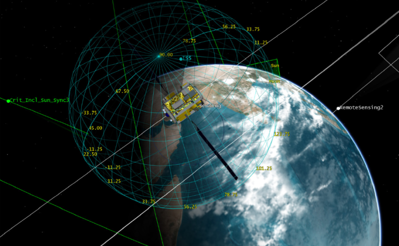
In this installment, I have just scratched the surface of satellite guidance and control. In future columns I will go into more detail, and I will consider satellite aspect control, communication and data links, position knowledge and more.
This is the second in a series of articles on space travel offered by Steve Mills. Read Steve's initial offering in the Autumn 2024 SEA Newsletter HERE.
Teachers: Check out these modules in the SEA Lesson Plan Library related to Newton's Laws of Motion: Foucault's Pendulum and Fizz-Pop! Action-Reaction.

[ Back to Top ]


From NOAA's News & Features
at https://www.noaa.gov/news/cop29-un-climate-summit-comes-to-conclusion-our-top-6-highlights
November 26, 2024

This past weekend, the 29th United Nations Climate Change Conference of the Parties (or COP29) wrapped up in Baku, Azerbaijan, where ministers unveiled a new finance goal to help countries safeguard their people and economies from climate disasters while seizing the opportunities of the clean energy boom. Over the course of the two-week conference, NOAA played a vital role, sharing its scientific expertise and innovative solutions to drive international collaboration on climate adaptation and resilience.
"As the climate crisis intensifies, NOAA’s expertise is more relevant and crucial than ever," said NOAA Administrator Rick Spinrad, Ph.D. "We are proud to see our contributions shape meaningful global progress and we remain dedicated to empowering communities, individuals, and industries with the knowledge and tools they need to adapt and thrive."
COP29 convened representatives from nearly 200 countries over the last two weeks, along with scientists, policymakers, business leaders and environmental advocates, under the theme of "in solidarity for a greener world." This year’s summit emphasized climate finance, building adaptive capacity, integrating nature-based solutions and accelerating clean energy transitions, with a special focus on climate-vulnerable regions.
Throughout the conference, during side events and bilateral meetings, NOAA experts in Baku reinforced the importance of data-driven decision-making and actionable science.
Looking ahead, NOAA will continue its work with international partners to implement COP29 outcomes and drive progress toward a sustainable, resilient future.

[ Back to Top ]
By Elyna Niles-Carnes, NASA News & Events
at https://www.nasa.gov/centers-and-facilities/kennedy/nasa-kennedy-top-24-stories-of-2024/
December 12, 2024
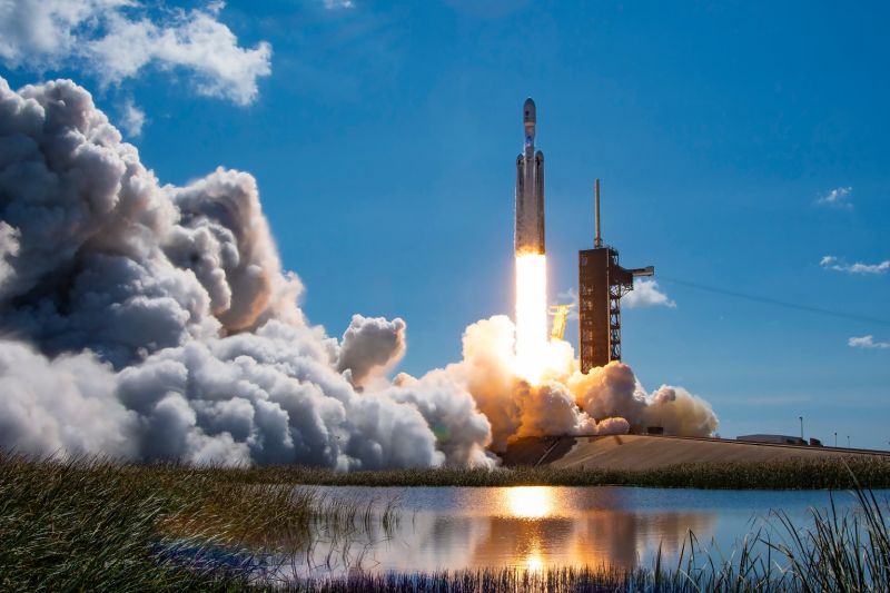
From sending crew members to the International Space Station to launching a spacecraft to Jupiter’s icy moon Europa to determine if it could support life, 2024 was a busy record setting year for NASA and its partners at Kennedy Space Center in Florida.
The first flight of NASA’s CLPS (Commercial Lunar Payload Services) initiative lifted off with Astrobotic’s Peregrine Mission One lunar lander aboard the inaugural launch of United Launch Alliance’s (ULA) Vulcan rocket on Jan. 8 from Space Launch Complex-41 at Cape Canaveral Space Force Station in Florida to study the lunar exosphere, thermal properties, and magnetic fields on the Moon’s surface. This mission became the first U.S. commercial lander to launch to the lunar surface; however, the spacecraft experienced a propulsion issue that prevented the landing on the Moon.

[ Back to Top ]

From NOAA's National Environmental Satellite, Data, and Information Service
at https://www.nesdis.noaa.gov/news/noaas-goes-satellites-can-provide-quicker-detection-of-large-methane-emissions
December 2, 2024
Innovative use of NOAA’s geostationary satellites (GOES) has given scientists a new way to detect large methane emissions faster and more accurately. Results of a new experiment show the Advanced Baseline Imager (ABI), the highly advanced camera flying on the GOES-16, GOES-18 and the newly launched GOES-19 satellites, is able to pinpoint leaks or venting of methane—a potent greenhouse gas—as often as every seven seconds. NOAA scientists say the experimental verification of GOES methane data will lead to faster, more complete data on the location—and amount—of methane emissions and successful mitigation efforts, when there are accidental leaks.
For the experiment, NOAA scientists teamed up with experts from Harvard University and Carbon Mapper, a nonprofit organization, to examine the potential use and benefit of this feature for tracking and quantifying methane emissions.
Methane, one of the most potent global greenhouse gases, poses serious challenges to climate stability. Despite its relatively short atmospheric lifespan compared to carbon dioxide (CO₂), methane's intense heat-trapping abilities—more than 25 times that of CO₂—make it a major contributor to global warming. Methane detected by GOES can come from both natural and human-made sources. Major contributors include: agriculture such as cattle farming and manure management, fossil fuel extraction from oil and natural gas fields and pipelines, and waste management in landfills where organic material decomposes without oxygen.

[ Back to Top ]
From NASA Jet Propulsion Laboratory
at https://www.nasa.gov/missions/mars-2020-perseverance/perseverance-rover/nasas-perseverance-rover-reaches-top-of-jezero-crater-rim/
December 12, 2024
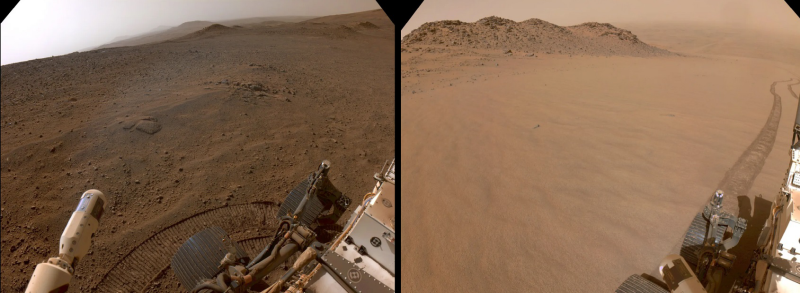
NASA’s Perseverance Mars rover has crested the top of Jezero Crater’s rim at a location the science team calls "Lookout Hill" and rolling toward its first science stop after the monthslong climb. The rover made the ascent in order to explore a region of Mars unlike anywhere it has investigated before.
Taking about 3½ months and ascending 1,640 vertical feet (500 vertical meters), the rover climbed 20% grades, making stops along the way for science observations. Perseverance’s science team shared some of their work and future plans at a media briefing held Thursday, Dec. 12, in Washington at the American Geophysical Union’s annual meeting, the country’s largest gathering of Earth and space scientists.
"During the Jezero Crater rim climb, our rover drivers have done an amazing job negotiating some of the toughest terrain we've encountered since landing," said Steven Lee, deputy project manager for Perseverance at NASA's Jet Propulsion Laboratory in Southern California. "They developed innovative approaches to overcome these challenges — even tried driving backward to see if it would help — and the rover has come through it all like a champ. Perseverance is 'go' for everything the science team wants to throw at it during this next science campaign."

[ Back to Top ]


From NOAA's National Environmental Satellite, Data, and Information Service
at https://www.nesdis.noaa.gov/news/noaa-shares-first-imagery-goes-19-suvi-instrument
October 29, 2024
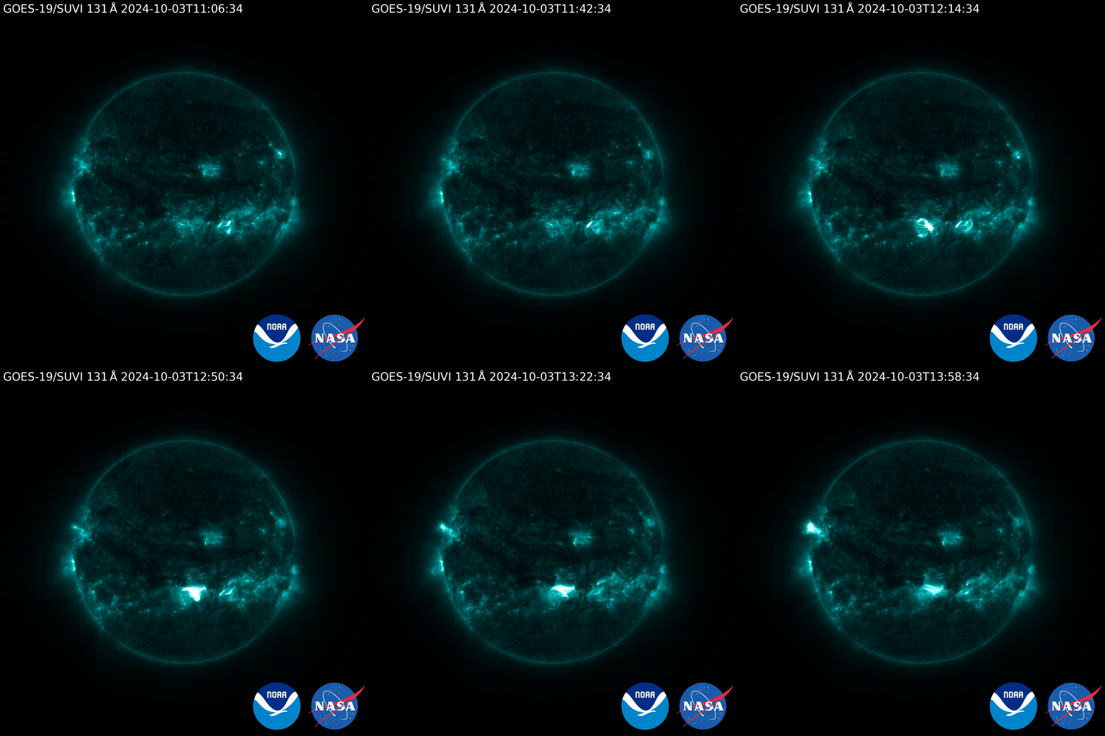
The Solar Ultraviolet Imager, or SUVI, onboard NOAA’s GOES-19 satellite, which launched on June 25, 2024, began observing the sun on Sept. 24, 2024. SUVI monitors the sun in the extreme ultraviolet portion of the electromagnetic spectrum to watch for hazardous space weather that could affect Earth.
The sun's upper atmosphere, or solar corona, consists of extremely hot plasma, which is ionized gas. This plasma interacts with the sun's powerful magnetic field, generating bright loops of material that can be heated to millions of degrees. Outside hot coronal loops, there are cooler regions called filaments which can erupt and become a key source of space weather when the sun is active. Filaments and active regions sometimes produce coronal mass ejections (CMEs), hurtling huge tangled clouds of plasma and magnetic field out into the solar system.

[ Back to Top ]
From NOAA Atlantic Oceanographic & Meteorological Laboratory
at https://www.aoml.noaa.gov/unveiling-the-newest-hurricane-research-instrument-skyfora-streamsondes/
November 8, 2024
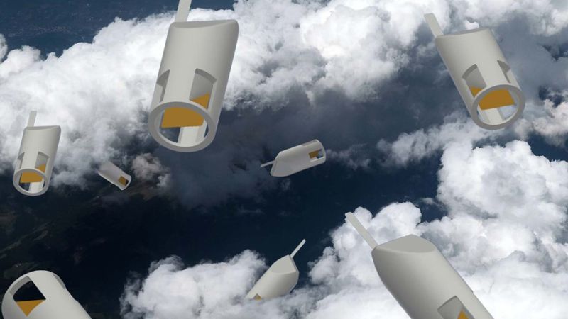
As Hurricane Rafael developed in the Caribbean, AOML researchers were inside the storm testing the newest experimental hurricane observation instrument: the Skyfora StreamSonde. The 2024 hurricane season marks the first year that Skyfora's StreamSondes were released in high volumes by NOAA's Hurricane Hunters for research and testing with a total of 91 sondes released. These sondes are the newest addition to NOAA's hurricane hunting toolbox, giving scientists the ability to gather more observational data from within a storm. These sondes will be released alongside dropsondes, airborne expendable bathythermographs, and uncrewed aircraft systems to gather real-time data from inside the storm. By experimenting with emerging technologies, NOAA aims to pioneer advancements that revolutionize hurricane research technology, ensuring more accurate forecasting and enhanced understanding of storm dynamics.
Much like dropsondes, StreamSondes are released from the bottom of the NOAA P-3 Hurricane Hunter aircraft to collect atmospheric measurements as they fall through the storm. However, StreamSondes are incredibly light, weighing only 14 grams. This allows them to fall slowly through the atmosphere at speeds of only 5 meters/second, eliminating the need for a parachute. Their slower descent rate allows them to remain aloft for extended periods of time, providing researchers with a greater volume and greater detail of atmospheric data.

[ Back to Top ]
From NOAA's Research
at https://research.noaa.gov/early-season-2023-wildfires-generated-record-breaking-surface-ozone-in-the-upper-midwest/
November 26, 2024
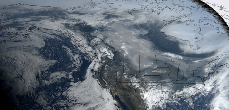
During the summer of 2023, Canada experienced its most intense wildfire season on record. More than 40 million acres burned, an area the size of Georgia, injecting an enormous amount of smoke into the atmosphere, where photochemical reactions generated ozone pollution. In late spring, which is early for the wildfire season, wave after wave of smoke billowing from burning forests in western Canada poured across the sky and into the upper U.S. Midwest.
A new analysis by NOAA’s Chemical Sciences Laboratory (CSL) found that ozone pollution readings in the Upper Midwest caused by these massive fires were the worst in decades.
"We were watching the Environmental Protection Agency's air quality indices, and all across the Upper Midwest they were showing ozone exceedances," said Owen Cooper, a research physical scientist at CSL. "On June 3, 2023, every ozone monitor in Iowa, about a dozen of them, exceeded the ozone standard of 70 parts-per-billion. It was unbelievable. Then it happened again on June 20th."

[ Back to Top ]


From NASA Jet Propulsion Laboratory
at https://www.jpl.nasa.gov/news/nasa-performs-first-aircraft-accident-investigation-on-another-world/
December 11, 2024
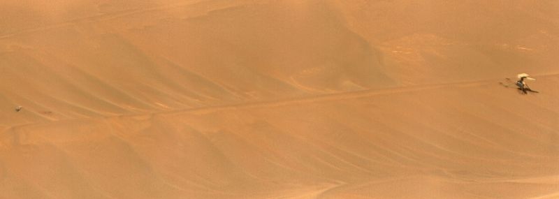
Engineers from NASA’s Jet Propulsion Laboratory in Southern California and AeroVironment are completing a detailed assessment of the Ingenuity Mars Helicopter's final flight on Jan. 18, 2024, which will be published in the next few weeks as a NASA technical report. Designed as a technology demonstration to perform up to five experimental test flights over 30 days, Ingenuity was the first aircraft on another world. It operated for almost three years, performed 72 flights, and flew more than 30 times farther than planned while accumulating over two hours of flight time.
The investigation concludes that the inability of Ingenuity's navigation system to provide accurate data during the flight likely caused a chain of events that ended the mission. The report's findings are expected to benefit future Mars helicopters, as well as other aircraft destined to operate on other worlds.

[ Back to Top ]
From NOAA Research
at https://research.noaa.gov/no-sign-of-fossil-fuel-pollution-peak-as-the-world-falls-further-behind-climate-targets/
November 13, 2024
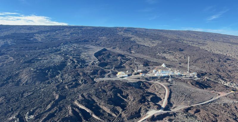
Emissions of carbon caused by fossil fuel pollution continued to grow slightly in 2023 to 36.8 billion metric tons of carbon dioxide, setting yet another new record despite increasingly urgent warnings from scientists about the need for steep and immediate decreases.
Preliminary estimates compiled by the Global Carbon Budget project indicate that the amount of carbon dioxide (CO2) released into the atmosphere by fossil fuels will increase by another 0.8% in 2024, which would raise yearly emissions to 37.4 billion metric tons of CO2.
"The impacts of climate change are becoming increasingly dramatic, yet we still see no sign that burning of fossil fuels has peaked," said Professor Pierre Friedlingstein, of University of Exeter's Global Systems Institute, who led the study. "Until we reach net zero CO2 emissions globally, world temperatures will continue to rise and cause increasingly severe impacts."
The Global Carbon Budget is an annual report that tracks changes in how much carbon is emitted to the atmosphere and how much is absorbed by carbon sinks such as terrestrial plants, soils, and the ocean. Roughly 25% is absorbed by the ocean and just under 30% by land ecosystems. The rest remains in the atmosphere, where it continues to trap heat for hundreds of years.

[ Back to Top ]
From NOAA's Atlantic Oceanographic & Meteorological Laboratory
at https://www.aoml.noaa.gov/new-noaa-research-predicts-an-increase-in-active-atlantic-hurricane-seasons/
November 18, 2024
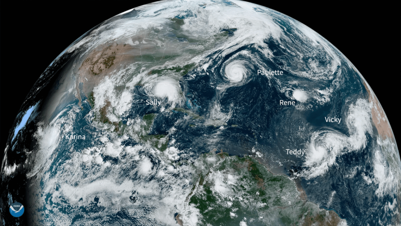
Tropical cyclones are among the most deadly and costly natural disasters that affect the United States and many other countries each year. This has led the scientific community to prioritize improving tropical cyclone prediction and the understanding of how tropical cyclone activity has changed and will change in the future. In a new study published in Science Advances, NOAA and partner researchers project an increase in the variability of Atlantic tropical cyclone activity, leading to more active and inactive hurricane seasons and less near-normal seasons.
The study investigates how the frequency and accumulated cyclone energy (ACE) in the North Atlantic might change in the future. ACE is the measure of total seasonal activity used by NOAA scientists to look into past and future changes in tropical cyclone activity, focusing on changes that occur between or over two or more years and the impact of a changing climate. Researchers examine why there have been so many active seasons in recent years. The results show both unusually active and inactive hurricane seasons have become more common since the 1990s, and computer models predict that by the middle of this century, the variability could increase by an additional 36%, with the biggest increase expected to occur in the central tropical North Atlantic, which refers to the mid-section of the North Atlantic Ocean where tropical storms and hurricanes most frequently form.

[ Back to Top ]


From NOAA National Environmental Satellite, Data, and Information Service
at https://www.nesdis.noaa.gov/news/making-the-skies-safer-jpss-observations
December 2, 2024
The impact of weather on air travel cannot be overstated. During peak times, there can be more than 5,000 airplanes in the sky over the United States, carrying passengers and cargo as part of the more than 16 million flights managed annually by the Federal Aviation Administration (FAA). Many weather-related issues, including storms, ice, turbulence, fog, winds, wildfire smoke, and volcanic ash can cause unsafe flying conditions. Addressing these risks requires advanced technology and timely information, with observations from the Joint Polar Satellite System (JPSS) enhancing forecasting to keep the skies safe.
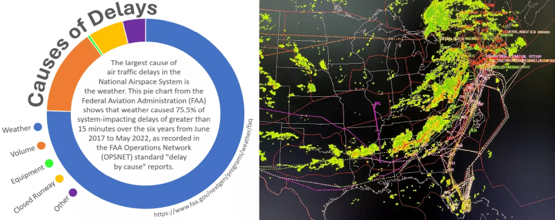
Instruments onboard JPSS satellites provide crucial data used by the National Weather Service (NWS) Aviation Weather Services, helping the FAA to anticipate and mitigate weather-related risks. Central to this effort is NOAA's High-Resolution Rapid Refresh (HRRR) model, which assimilates JPSS data from the Cross-track Infrared Sounder (CrIS) and the Advanced Technology Microwave Sounder (ATMS). CrIS and ATMS provide high-resolution three-dimensional atmospheric temperature, pressure, and moisture profiles that enhance the HRRR model's accuracy. This allows meteorologists to better predict storm formation, guide air traffic controllers in rerouting flights, and help prevent costly delays while maintaining passenger safety.

[ Back to Top ]
From NASA Jt Propulsion Laboratory
at https://www.nasa.gov/missions/juno/nasas-juno-mission-uncovers-heart-of-jovian-moons-volcanic-rage/
December 12, 2024
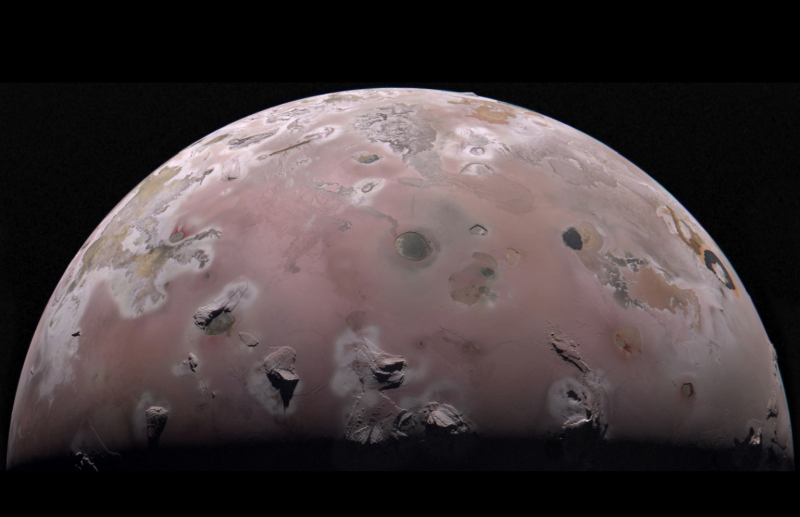
Scientists with NASA's Juno mission to Jupiter have discovered that the volcanoes on Jupiter's moon Io are each likely powered by their own chamber of roiling hot magma rather than an ocean of magma. The finding solves a 44-year-old mystery about the subsurface origins of the moon's most demonstrative geologic features.
A paper on the source of Io's volcanism was published on Thursday, Dec. 12, in the journal Nature, and the findings, as well as other Io science results, were discussed during a media briefing in Washington at the American Geophysical Union's annual meeting, the country's largest gathering of Earth and space scientists.
About the size of Earth's Moon, Io is known as the most volcanically active body in our solar system. The moon is home to an estimated 400 volcanoes, which blast lava and plumes in seemingly continuous eruptions that contribute to the coating on its surface.

[ Back to Top ]
From NOAA News & Features
at https://www.noaa.gov/news/fact-check-debunking-weather-modification-claims
October 23, 2024
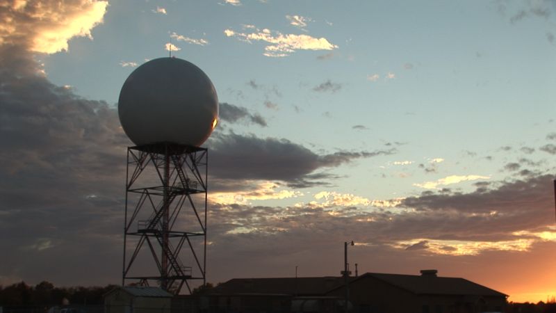
As the southeastern United States reels from the impact of two historic hurricanes, a large amount of disinformation about nonexistent weather manipulation technology is spreading across the internet, particularly on social media platforms.
Below, NOAA identifies some of the inaccurate claims circulating online and provides science-based facts and information in response.

[ Back to Top ]


Resource Collections -- Resources to help integrate NOAA science into formal and informal education. Education resources are distributed across many websites and program offices at NOAA and partner websites. This portal is designed to help you access these resources from one location. Materials are organized by themes aligned with common teaching topics. From NOAA SEA to Sky: Education resource databas, find lessons about oceans and coasts, weather and atmosphere, climate, marine life, freshwater, and data resources. Special topics include career resources, conference information, and links to other federal education resources. Find NOAA education resources at https://www.noaa.gov/education/resource-collections.
Next Gen STEM for Educators. Find Next Gen STEM learning opportunities for students in multiple settings – in school, afterschool programs informal institutions like museums and science centers, and at home. Explore STEM resources and opportunities for K-12 educators. Connect your students with astronauts aboard the space station. Explore lesson plans and activities for grades K-12 in English and Spanish. Join NASA's Next Gen STEM Community of Practice whos members sign up for engagement events, view and chat with other members of similar interests, read exclusive STEM content, and access resources such as lesson plans and interactive media. Subscribe to the NASA Express Newsletter for the latest resources. For these and much more, visit https://www.nasa.gov/learning-resources/for-educators/.
Don't forget SEA's More Lessons from the Sky lesson plan library and Using Satellites in Education. The library houses forty lesson plans for grades K-12 which are checked and updated every 1-2 years. Each contains detailed presentation notes, background information, and access to comprehensive resources. Using Satellites covers everything from building and operating your own weather satellite receiving station to comprehensive how-to-do-it help for using every tool for accessing, analyzing, and interpreting satellite data imagery. Start or continue your exploration here --> https://Satd.org.

[ Back to Top ]


From the petroglyphs of ancient societies to the stunning views of our planet from space, humans have endeavored to visualize and accurately map our world. As early geographers recorded the experiences from travelers and merchants, they created lists of places and geographic features. To spatially represent these data, geographers mapped the distances between features from the perspective of the traveler. Maps have aided navigation, settled disputes, and illustrated the extent of an Empire's power. The desire to discover what was beyond the edges of the map - to venture into the unknown - brought about an Age of Exploration that continues into the 21st century with space exploration. (NASA Landsat Science)
Today, an array of Earth-looking satellites helps us visualize and monitor the surface of the Earth in greater detail than early geographers could have imagined. One of those satellite programs is Landsat. It monitors land use and changes. Landsat is more than just a camera with a great zoom lens orbiting Earth. Landsat measures light from the Sun reflected by Earth. The light that Landsat measures reveals a lot about the Earth's surface, since different surface features reflect various types of light. (NASA Landsat Science)
In this lesson, learners will review electromagnetic radiation (light), how various wavelengths of light are reflected from Earth's surface features and monitored by instruments on Landsat satellites. Using Landsat data sets, learners construct multispectral images, analyze and interpret the multispectral images to discover applications in both life an physical sciences.
| Grade Level: | 9-12 |
| Time Requirement: | 2-3 class periods |
| Prerequisites: | None |
| Relevant Disciplines: | Physical, Life, Earth & Space Sciences |

[ Back to Top ]
Share your satellite-based lesson ideas with the teaching community.
Send us a full lesson plan, or simply suggest a lesson idea. If you found the idea online, please share the source as well. The lesson can be about anything that helps connect learners with satellite-based technology - any grade level K-12 - any STEM subject area or geography.
"Satellite-technology" includes any part of the science, math, engineering, or technology of satellites, rockets, and remote sensing instruments as well as the use of any environmental satellite data to explore questions related to aspects of global change and local impacts in the long term, short term, and catastrophic time frames. Of special interest are lessons providing opportunities for learners to inquire, experiment, and apply mathematics.
Perhaps you designed a lesson yourself - we will happily prepare it for future publication in More Lessons from the Sky and inclusion in the SEA Lesson Plan Library. Perhaps you found a worthy lesson plan published elsewhere - we swill do the research for possible inclusion in a lesson plan spotlight. In either case, you will receive full credit for developing and/or bringing the lesson to the attention of the teaching community. Don't forget to share your insights if you tried the lesson with students.
Please share your ideas at SEA.Newsletter@SatEd.org.
[ Back to Top ]