OUR VISION
The world's finest educators supporting science, technology, engineering, and math (STEM) learning for pre-kindergarten to post-graduate students using real-world applications from satellites and satellite data.
OUR MISSION
To enhance the education environment to excite students about science, technology, engineering, and math through space-based technology -- satellites and satellite data.

Beyoncé

Now more than ever the people are responsible for the character of their Congress. If that body be ignorant, reckless, and corrupt, it is because the people tolerate ignorance, recklessness, and corruption. If it be intelligent, brave, and pure, it is because the people demand these high qualities to represent them in the national legislature...If the next centennial does not find us a great nation...it will be because those who represent the enterprise, the culture, and the morality of the nation do not aid in controlling the political forces.
James A. Garfield

TABLE OF CONTENTS
Click a RED link to view article
ASSOCIATION NEWS
PRESIDENT'S CORNER
EARTH SYSTEM SCIENCE
STEVE'S SPACE
SATELLITES
ACCESS
ANALYZE
APPLY
For Teachers
More Lessons
from the Sky

September 1, 2024
In this issue, the top story is the SmallSat Education Conference October 26-27, 2024 at Kennedy Space Center in Florida -- for teachers and students middle school through college. ASSOCIATION NEWS also announces the posting of the the minutes of the SEA Annual Meeting of Members August 2 in SatEd.org Member Services.
The SEA Newsletter welcomes Steve Mills writing about conditions in space. Simon Cracknell discusses space debris, Ron Gird reviews the 34th annual State of the Climate report, and John Moore updates us on the expansion of the A3Sat project.
The SATELLITES section brings us up to date on GOES-U now in orbit as GOES-19; development of Europa Clipper, the largest robotic spacecraft to date; and the next generation of asteroid hunting satellites.
ACCESS includes new information about the GOES-19 magnetometer; new tools for wildfire detection and warning; and a new, game-changing sensor for ocean color.
ANALYZE highlights the decline of ozone-depleting chemicals; explains the relationship between super-marine heatwaves and global warming; and monitors Saharan dust blowing west over the Atlantic Ocean.
APPLY offers four things to know about an Atlantic Niña and the effectiveness of combining ocean and atmospheric data to improve ocean forecasting.
A LOOK BACK recalls William Herschel's discovery of Saturn's moon Enceladus 235 years ago.
FOR TEACHERS includes descriptions and links to lots of teaching and learning resources from SEA, NASA, NOAA, and ESRI.
MORE LESSONS FROM THE SKY presents a recent update (June 2024) of Tracking Hurricane Sandy.
Enjoy!
--Editor

[ Back to Top ]

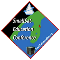
Have you registered for the SmallSat Education Conference yet? It's not too late! Registration is open online at https://www.smallsateducation.org
The 2024 SmallSat Education Conference will take place in The Center for Space Education at Kennecy Space Center in Florida, October 26-27. The conference is focused on educational opportunities and curricula for community college, high school and middle school faculty and students. Registration rates are inexpensive and worth every penny. Register now at the above link.
For more than a third of a century, the Satellite Educators Association (SEA) annually produced the outstanding Satellites & Education Conference bringing teachers together with representatives from government agencies (especially NOAA and NASA), aerospace industry (Aerospace Corp, Raytheon, Boeing, Northrop Grumman, among others), and university research -- all focussed on helping teachers engage learners with satellite related technologies. Continuing that tradition, SEA is pleased to sponsor and support the third annual SmallSat Education Conference in Florida. Members of the SEA Executive Committee have been actively involved in planning the second and third SmallSat Education Conference, and SEA members John Moore and Pete and Paula Arvedson presented sessions at the 2023 conference.
Today, small sats are the next evolutionary step in student engagement with satellite technology: CubeSats, single, stacked, or in arrays; picosats; simulators, emulators; carried aloft on kite, balloon, or drone, or rocket-launched. Small Sats make satellite engineering, technology, and remote sensing accessible to middle school, high school, and college students at an affordable price.
Don't miss this exciting conference along with a chance to visit Kennedy Space Center. Register today at https://www.smallsateducation.org.
Why Should You Attend the SmallSat Education Conference?
– an evolutionary answer...
The first Satellites & Education Conference (1988) and the foundation of the Satellite Educators Association (1989) was accomplished by teachers interested in using weather satellite direct read-out with students in the classroom. The early equipment included a home-built antenna, a short-wave radio capable of receiving frequencies just below the amateur radio 2-meter band, and a used/refurbished wet paper facsimile printer. A special, circular slide rule-like calculator produced by NOAA was used to predict the location and timing of an overhead pass by a NOAA polar-orbiting weather satellite using updated orbital elements mailed periodically from NOAA on postcard. A receiving station in Southern California, for example, could receive a real-time image of the Earth showing Cabo San Lucas in Baja California to Alaska with a width from east of the Rocky Mountains to half-way to Hawaii. Other direct read-out stations could receive real-time imagery with similar length and width relative to their geographical locations.

Those gathered at the first Satellites & Education Conference discussed how teachers with receiving stations in Washington, Southern California, Maine, Pennsylvania, Florida, and England might share such imagery to develop a broader, more global perspective with students -- a major problem since all were equipped with 2400 baud MODEMs on dedicated telephone lines (and no classroom computers, yet).
Within a few short years, two important developments provided solution as well as a significant boost to interest in the Satellites & Education Conference: the Internet and classroom computers. It was a time when desktop computers were increasingly available for school and student use. Satellite tracking, data visualization, and image analysis provided a viable answer to the most common question, "OK. Now that we have computers, what are we going to do with them?" The availability of the World Wide Web and Internet "exploded" during the 1990s. With continued support from NOAA, NASA, and the U.S. Navy, the Satellites & Education Conference met a need and flourished.
Six decades of satellite-based remote sensing data have since been processed and archived by NOAA, NASA, and the USGS, among others, and made freely available via the Internet. Advanced computer technology (compared to 1990) is in the hands of every person with a mobile phone, and many organizations provide their own visualizations of data.
Today, small sats are the next evolutionary step in student engagement with satellite technology: CubeSats, single, stacked, or in arrays; picosats; simulators, emulators; carried aloft on kite, balloon, or drone, or rocket-launched. Small Sats make satellite engineering, technology, and remote sensing accessible to middle school, high school, and college students at an affordable price.
To learn more about Small Sats in your classroom, SEA invites and urges you to attend the SmallSat Education Conference, October 26-27, 2024 at Kennedy Space Center. Registration is now open online with special rates available for attending students and teachers. Please visit https://www.smallsateducation.org for more information and registration.
Don't wait! Register today!
[ Back to Top ]
The annual meeting of Satellite Educators Association (SEA) members was virtual on August 2, 2024. The meeting was chaired by SEA's new President Simon Cracknell from his home in the United Kingdom. Members gathered on ZOOM at 9:30 AM PDT for a social time, greeting old friends and welcoming members. The meeting was called to order at 10:00 AM PDT and ran approximately 2 hours. The minutes of the meeting are posted on SatEd.org in Member Services.
Highlights of the meeting included reports from the Secretary, Treasurer, Membership Chair, and Web Manager. Since the Conference Coordinator officially retired from California State University, Los Angeles, she reported no success in finding a replacement at Cal State LA or University of California Irvine. Consequently, the membership voted not to produce a Satellites & Education Conference in 2024-2026 while other possibilities are explored. The members did vote to support once again the SmallSat Education Conference in Florida, October 26-27, as this conference very closely aligns with 35 years of our Satellites & Education Conference. To ensure SEA's activities remain loyal to its own corporate organization, a committee was formed to review the SEA By-Laws with an eye toward revision if necessary. Any revision will be voted by the membership at the 2025 annual meeting.
[ Back to Top ]
Why should I renew now? SEA membership is annual running from August 1 to July 31 of the following year. For just $20 per year, membership in the Satellite Educators Association entitles you to voice and vote at the annual SEA Meeting during the summer as well as access to important members-only announcements and online member services.
In its commitment to making online payment easier and more secure, SEA's merchant banker/payment card processor changed the configuration of its online hosted payment pages. SEA utilizes such hosted payment pages for greater security by ensuring SEA never uses or has access to any of the user's payment card data. The old payment page configuration ended July 31. So, as of August 1, SEA members encountered error messages and were unable to renew membership by credit card. Working jointly with representatives from the payment card processor, SEA's Web Manager has been able to isolate and address several problem areas while configuring new payment pages.
The ability to make payments to SEA online by credit card will be available again very soon when additional updates to SatEd.org are posted. Meanwhile, those wishing to join, renew, or donate to SEA should follow the same online pathways at SatEd.org, select payment by check, print the form and mail it with a check.
[ Back to Top ]


By Simon Cracknell, President, Satellite Educators Association
Since childhood I have been fascinated by the act of launching large satellites into orbit, hitching a lift on the back of a space vehicle powered by tonnes of rocket fuel, travelling at speeds in excess of 17,800 mph (28,650 kph). My personal affinity with all things space dates back to a book I found in the school library as a young boy with the specifications of the Skylab space station in the mid 1970’s. The book was dated even as I was reading it as an 11-year-old, but the notion that people could work and study and live in space fired the imagination.
An enormous build-up of technology in orbit has developed with a huge range of environmental and social benefits. Space technology offered so much promise and opportunity, it seems unlikely anyone would have envisioned it would later become a major source of concern.
Scientists currently monitor more than 29,000 pieces of debris that are larger than a softball, according to the European Space Agency (ESA) including approximately 3000 defunct satellites slowly decaying in orbit. Most orbiting debris is far too small to track reliably, measuring 0.4 in (a centimetre) wide. Some researchers estimate there are up to 100 trillion such pieces which are not tracked at all. (Is anyone worried yet?)
As classroom teachers of students 16 and older, we are required at my school to teach about the ‘global commons.’ These are best described as shared resources accessible to all but not owned or controlled by a single nation. Global commons originally included the High Seas (i.e. international waters), the atmosphere, and Antarctica but has since expanded to include cyber space and outer space. It may help us to understand the ‘space junk’ problem if we look at how some of the original global commons have been managed.
Applying the word “crisis” to what has been happening in the high seas, and to some extent in Antarctica, can be a challenge for society, as changes are not always visible and not regularly discussed. With rapid economic growth, particularly among some of the most populous nations on Earth, it seems inevitable that people would look for new places to exploit – to change our treatment of physical environments on Earth. Some examples of more obvious changes include overfishing, hunting some whale species to near extinction, and melting polar ice. Awareness of such changes may serve as a precursor to what is happening in orbit. If one does not work, study, or pay attention in a sector associated with each change, the changes will likely be missed; direct personal impact will not be realized. The true environmental costs of exploitation can be obscured in the global consciousness until it's too late. What can be done?
Treaties have been used to great effect in our recent past, such as the Montreal Protocol in 1987, which saw the banning of ozone depleting substances. They posed such a profound risk, that it resulted in unprecedented levels of international cooperation and collaboration between private and public sectors to ensure no further damage was done. Since that agreement, levels of stratospheric ozone over Antarctica have returned to near-normal concentrations -- a testament to how effective a treaty can be when led by sufficiently motivated stakeholders.
The 1967 Outer Space Treaty came into force with 115 signatories but it does not really address the current issue of space debris. It was designed with a very different focus, addressing the concerns of the time such as orbital deployment of weapons of mass destruction including nuclear. The treaty does emphasise the need to use space for peaceful purposes, but it also stands accused of being very open to interpretation. Nonetheless, since the threat of nuclear annihilation has subsided, as has the Cold War, no further development of this treaty has been accomplished.
A little like the Outer Space Treaty, the 1962 Convention on the High Seas treaty has been characterised by inadequate governance which has led to overfishing, as well as habitat destruction, deep sea mining, and plastic pollution. However, there are promising signs on the horizon such as the 2023 High Seas Treaty although it was in negotiation for 10 years. It has now been adopted by the UN General Assembly but only 7 nation states have ratified it at the time of this writing. Sixty (60) nations must ratify this treaty before it takes full effect.
The perceived lack of collective urgency from our nations’ governments may be due to other more pressing concerns. The more common this response, the less the likelihood the crisis building in near Earth orbit will garner much consideration in the near future.
It should be less challenging to bring the public consciousness to a heightened state of awareness concerning the space debris crisis. Stories that make it to the news media may help focus the mind. For example, consider the incident reported on June 27th this year about a Russian satellite shattering into more than 100 pieces causing the astronauts on the International Space Station (ISS) to shelter in a docked capsule. That story really resonates.
Objects in space can travel faster than 15,600 mph (25,200 kph). If something the size of a pea were to strike a functioning satellite, or worse still, a habitable space vehicle, the outcome could be devastating. In 2016, a speck of paint from a piece of debris, collided with a window on the International Space Station, (ISS) causing a quarter inch gouge in it. Fortunately, nobody was hurt and repairs could be made. There are many more such reports, where risk to life is significant and damage is sustained by satellites belonging to various nations, costing money and ultimately adding to the number of tracked pieces that themselves can become a problem.
Space debris can and does fall to Earth. Of 200 to 400 pieces of space junk tracked as they come through the atmosphere, some burn up in the atmosphere. Some splash down in the ocean covering 70% of the planet’s surface. The rest reach the Earth’s surface crashing in unexpected places and making national news.
One such story in August 2022 was about a chunk of a SpaceX Crew Dragon spacecraft that landed on a sheep farm in Australia. On March 8th, 2024, a mysterious object crashed through two floors of a Florida family’s home. NASA later confirmed that it was part of a cargo pallet of used batteries that had been jettisoned from the ISS three years earlier. Such incidents are becoming increasingly common. In May 2024, a part of a different SpaceX Dragon capsule crashed in a luxury campsite in the mountains of North Carolina. The same month, another large piece crash landed on a Canadian farmer’s property in Saskatchewan.
If having debris from space landing on the surface of the planet is not bad enough, we must also contend with the risks of atmospheric pollution. Recent studies suggest that deorbiting spacecraft may be polluting the upper atmosphere and even depleting ozone. Clearly, there needs to be broader, ongoing study to fully understand these risks.
With the space debris crisis building, there needs to be greater multinational cooperation similar to and significantly better than the cooperation seen in the 1987 Montreal Protocol. All hope for robotic and human exploration of our Solar System and beyond calls for raising the levels of public awareness and action related to near-Earth space to the same level applied to our oceans and atmosphere.
[ Back to Top ]

By Ron Gird, Meteorologist and former Satellite/Spaceflight and Outreach Program Manager for the National Weather Service
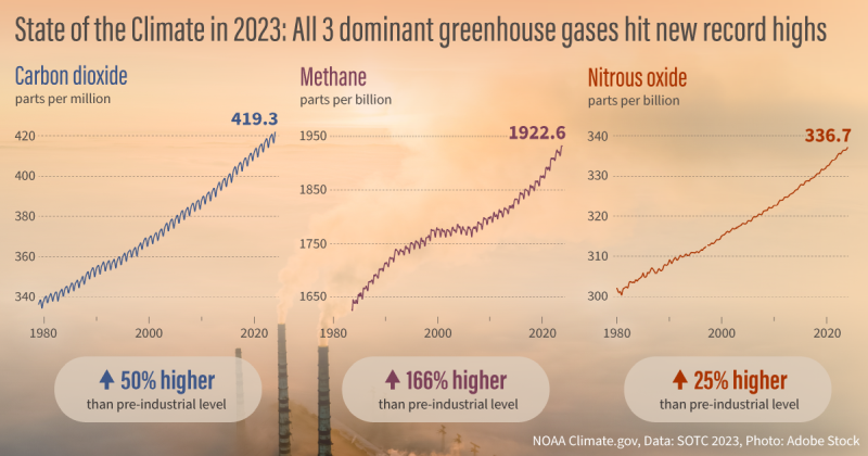
"Greenhouse gas concentrations, the global temperature across land and the ocean, global sea level and ocean heat content all reached record highs in 2023," according to the 34th annual State of the Climate report. "Since climate, weather, and water affect al life on our ocean planet," the following summary should help us monitor what it means to be a Weather-Ready Nation. -- Ron
From NOAA News & Features
at https://www.noaa.gov/news-release/international-report-confirms-record-high-global-temperatures-greenhouse-gases-in-2023
August 22, 2024

The international annual review of the world’s climate, led by scientists from NOAA’s National Centers for Environmental Information (NCEI) and published by the Bulletin of the American Meteorological Society (BAMS), is based on contributions from nearly 600 scientists in 60 countries. It provides the most comprehensive update on Earth’s climate indicators, notable weather events and other data collected by environmental monitoring stations and instruments located on land, water, ice and in space.
"The BAMS State of the Climate report is the product of an international effort to more fully understand global climate conditions in 2023," said NCEI Director Derek Arndt. "This report documents and shares a startling, but well established picture: We are experiencing a warming world as I speak, and the indicators and impacts are seen throughout the planet. The report is another signpost to current and future generations."
[ Back to Top ]


By John D. Moore, Executive Director, Institute for Earth Observations at Palmyra Cove, New Jersey
In March 2024, the Institute for Earth Observations hosted GLOBE’s North America Regional Meeting (NARM). It underscored the critical role of Satellites and Remote Sensing addressing environmental challenges within the GLOBE community at large. Through collaborative efforts and a shared commitment to science and sustainability, participants reaffirmed their dedication to empowering the next generation of Earth system scientists.
In summary, what is now known as the NE NARM 2024 Manifesto found that integrating satellites and remote sensing into the NASA GLOBE Program offers numerous benefits including enhanced data collection, spatial and temporal coverage, educational opportunities, interdisciplinary learning, global perspectives, and support for scientific research. By leveraging satellite data, the GLOBE Program can deepen students' understanding of Earth's systems and empower them to become informed stewards of the environment. Participants included NASA scientists/educators from Goddard Space Flight Center, Langley Research Center, NASA Headquarters and PI’s from several NASA Sci-Act Projects as well as GLOBE Partners. This report was presented at the GLOBE Annual Meeting held at SUNY Fredonia in July.
In the development of educational tools that truly support STEM Education, the A3SatPQ project, which began in the summer of 2023, is paving the way for future engineers, computer scientists, and educators by providing students with hands-on experience in building and launching SmallSat Emulators. With continued support from NASA GLOBE Mission Earth (GME), the project saw significant design refinements and implementation work during the summer of 2024. These efforts culminated in the introduction of A3SatPQ at Alba Orbital’s "Side Meeting" during the 2024 SmallSat Conference in Utah last month. (Not to be confused with the SmallSat Education Conference in Florida.)
The A3SatPQ project builds on the success of the A3Sat v2 CubeSat, a "Tier 2 Ready for Space with Modifications" Emulator, which has been incorporated into educational programs across the United States and with international partners. The A3Sat v2 has successfully launched on High Altitude Balloons (HAB), reaching over 100,000 ft (30.5 Km) and transmitting valuable data. The success of these launches is now driving efforts to explore payloads further, extending the project's reach and impact.
The mission of A3SatPQ is to broaden, even further, participation in the precollege education community by introducing the PocketQube form factor—a compact 5 cm design compared to the 10 cm CubeSat—into K-12 education. Both A3Sat v2 and A3SatPQ were developed by high school students, some of whom are now pursuing further studies in STEM fields, an example of a clear "Pathway to Space" for the next generation.
A3SatPQ features two distinct design strategies:
A3SatPQLITE (Version 1): This version is lightweight and designed for accessibility. It includes a camera and a meteorological sensor, capable of transmitting real-time data to a ground station via Wi-Fi. Designed to be flown with NASA AEROKAT kites or readily available balloons, A3SatPQLITE offers an affordable and hands-on experience, even for early elementary students. By creating vertical profiles of atmospheric data and ground imagery, students gain a deeper understanding of Earth observation from space, using tools like the NASA GLOBE Observer App to compare their ground observations with satellite data.
A3SatPQ Emulator (Version 2): This more sophisticated version includes additional sensors and components, preparing students to build a "space-ready" PocketQube. The A3SatPQ Emulator can be flown as a tethered payload on balloons or attached to a drone, offering a more advanced project experience for students.
Through A3SatPQ, students not only gain practical experience in satellite technology but also engage in an authentic STEM experience that prepares them for future careers in the space industry.
Built on the same mission of the A3Sat Project, i.e. to Acquire -Analyze-Apply, the next steps for A3SatPQ involve expanding its reach and impact in several key areas, educational reach and advanced design/development.
These steps are designed to ensure that A3SatPQ continues to inspire and prepare the next generation of aerospace scientists, engineers, and educators.
These A3SatPQ projects ensure availability of tools to educate and to “prepare and inspire” students for future careers in the new space ecosystem and other STEM fields. The projects are poised to make a significant impact on both education and the broader satellite and remote sensing community.
Stay safe -- stay well!
For now, I'm John...and this is my Journey
[ Back to Top ]


By Steve Mills, Retired Systems Engineering Scientist; owner and Chief Engineer of Polymath Geo
Students are naturally curious, and most are eager to learn everything they can about space and space travel. But first there are many false or misleading ideas that they may need to unlearn. They may have picked up these ideas from science fiction, their everyday experiences or even misinformed teachers.
Here are some misconceptions that I had about space travel when I graduated from high school, and I am guessing that many students, or even well-educated adults also believe some of these to be true:
Fact - Space is much closer than most people think. Generically, the word “space” means a place with nothing there. So, when we talk about outer space, it is the place above us with nothing there, that is, where there is no atmosphere. This seems simple enough, except that the atmosphere does not have a sharp boundary where it suddenly ends, but instead, it slowly fades away, getting exponentially thinner and thinner with altitude. The somewhat arbitrary, but generally accepted boundary of outer space is 100 km (62 miles) above sea level. This limit is called the Kármán line, named after the JPL scientist, Theodore von Kármán, who in 1956 proposed 85 km as the aerodynamic limit of the atmosphere. By international convention, it was rounded up to 100 km. Others have defined the limit as low as 80 km, or as high as 120 km. At 100 km altitude, the density of the atmosphere is less than one millionth (1/1,000,000) of what it is at sea level, so it is very empty indeed. If the earth were the size of a basketball, then the atmosphere would be only 6 mm (0.23 inches) thick, about the thickness of a pencil. A spaceflight that reaches outer space, but does not achieve orbit, is called a suborbital flight.
Fact - Of course, since we have all seen launches sending satellites or humans into space, our first thought is that a rocket is what is needed to get to outer space. However, the problem with a rocket is that most of its fuel is used just to lift its own fuel. This creates a cycle of diminished returns where more and more fuel is needed just to get a little bit faster. The payload fraction is the payload mass divided by the total mass at launch. For rocket vehicles, the payload fraction is a miserable 1% to 5%. This is called the Rocket Equation Problem. Imagine an automobile that is 99% gas tank! When you see a very tall rocket on the launch pad, realize that mostly it’s a fuel tank.
Because of this problem, aerospace engineers and inventors look for alternatives to rocket launches. Here are some of them:
Fact — It is true that USSR was the first nation to put a satellite, Sputnik I, into Earth orbit on 4 October 1957. However, thirteen years before that on 20 June 1944 it was Germany, under control of the Nazi Third Reich, that launched a V-2 rocket to a height of 176 km, well above the Kármán line. So why is this not more widely known? Here are four reasons:
Fact — To get payloads into low-Earth orbit does require rockets powerful enough to reach a velocity of about 7.5 km per second. But if the space vehicle is simply launched vertically and then accelerates to that velocity, after reaching outer space, it will just fall back to Earth and then burn up in the atmosphere. To get into orbit requires more than power—it also requires guidance and control. To achieve a specific orbit requires that the spacecraft is at a very specific altitude, velocity and direction. The direction is usually close to horizontal, so a vertically launched rocket needs to change its direction by about 90 degrees. In the history of rocket engineering, the most challenging problems were not about power, but about guidance and control.
Fact — It is true that for any spacecraft that is in a stable orbit, everything inside will be weightless. The definition of "weightless" is the condition where there is no apparent gravity, but the word "apparent" is key here. The Earth’s gravitational field is the only thing that is keeping the satellite in its orbit. Without gravity the object would just drift away into endless space. An orbit is, by definition, the path whereby the inward gravitational force of the earth exactly counteracts the outward centrifugal force caused by the object’s curved path. Everything inside the spacecraft is in the exact same orbit as the spacecraft itself, so the gravitational and centrifugal forces exactly cancel one another in the same way they do for the spacecraft. However, if while in orbit, the spacecraft were to turn on its rockets and begin to accelerate, everything inside would experience a backward force and so would no longer be weightless.
You do not need to go into space to experience weightlessness. In an elevator in freefall, you would briefly experience weightlessness before it hits the bottom. There are, in fact, amusement park rides where one can safely experience brief weightlessness in a freefalling elevator. Another option is to take a ride in a Reduced-Gravity Aircraft. This is a conventional airplane that is flown in a special arched flight path designed to produce an upward centrifugal force that counteracts the downward force of gravity. In this aircraft it is possible to produce weightlessness as experienced in orbit, or reduced-gravity as one would experience on the moon. The first Reduced-Gravity Aircraft was first used by NASA in the 1950’s to train astronauts, and it was nicknamed “vomit comet” because a common side-effect of weightlessness is nausea. However, today this experience is not just reserved for astronauts. Zero Gravity Corporation offers Reduced-Gravity Aircraft flights to the public, using a commercial Boeing jet that is specially modified so that it can do these arched maneuvers.
This is the first in a series of articles on space travel offered by Steve Mills.
[ Back to Top ]


From NOAA's National Environmental Satellite, Data, and Information Service
at https://www.nesdis.noaa.gov/news/noaas-goes-u-reaches-geostationary-orbit-now-designated-goes-19
July 8, 2024
On July 7, 2024, NOAA’s GOES-U executed its final engine burn, placing the satellite in geostationary orbit 22,236 miles above Earth’s equator. Upon reaching this milestone, GOES-U was renamed GOES-19. GOES satellites are designated with a letter prior to launch and a number once they achieve geostationary orbit.
GOES-U launched on June 25, 2024, at 5:26 p.m. EDT, lifting off from Launch Complex 39A at NASA’s Kennedy Space Center in Florida, aboard a SpaceX Falcon Heavy rocket. The launch was managed by NASA’s Launch Services Program, based at Kennedy Space Center.
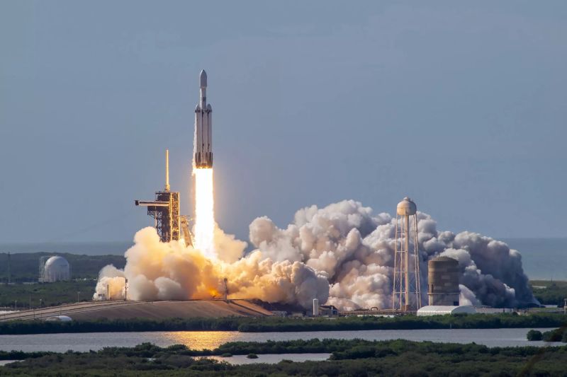
GOES-U separated from the SpaceX Falcon Heavy second-stage rocket at 9.56 p.m. EDT on June 25. Mission managers confirmed first-stage deployment of the spacecraft’s solar array at 10:18 p.m., and the satellite began operating on its own power.
[ Back to Top ]
From NASA Jet Propulsion Laboratory
at https://www.jpl.nasa.gov/news/nasas-europa-clipper-gets-set-of-super-size-solar-arrays
August 27, 2024
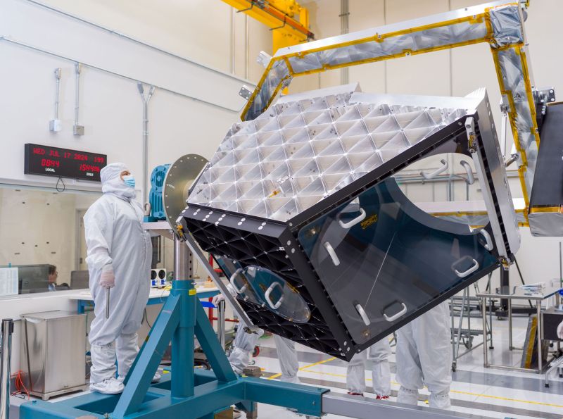
NASA’s Europa Clipper spacecraft recently got outfitted with a set of enormous solar arrays at the agency’s Kennedy Space Center in Florida. Each measuring about 46½ feet (14.2 meters) long and about 13½ feet (4.1 meters) high, the arrays are the biggest NASA has ever developed for a planetary mission. They have to be large so they can soak up as much sunlight as possible during the spacecraft’s investigation of Jupiter’s moon Europa, which is five times farther from the Sun than Earth is.
The arrays have been folded up and secured against the spacecraft’s main body for launch, but when they're deployed in space, Europa Clipper will span more than 100 feet (30.5 meters) — a few feet longer than a professional basketball court. The "wings," as the engineers call them, are so big that they could only be opened one at a time in the clean room of Kennedy’s Payload Hazardous Servicing Facility, where teams are readying the spacecraft for its launch period, which opens Oct. 10.
[ Back to Top ]
From NASA Jet Propulsion Laboratory
at https://www.jpl.nasa.gov/news/work-is-under-way-on-nasas-next-generation-asteroid-hunter
August 28, 2024
NASA’s new asteroid-hunting spacecraft is taking shape at NASA’s Jet Propulsion Laboratory in Southern California. Called NEO Surveyor (Near-Earth Object Surveyor), this cutting-edge infrared space telescope will seek out the hardest-to-find asteroids and comets that might pose a hazard to our planet. In fact, it is the agency’s first space telescope designed specifically for planetary defense.
Targeting launch in late 2027, the spacecraft will travel a million miles to a region of gravitational stability — called the L1 Lagrange point — between Earth and the Sun. From there, its large sunshade will block the glare and heat of sunlight, allowing the mission to discover and track near-Earth objects as they approach Earth from the direction of the Sun, which is difficult for other observatories to do. The space telescope also may reveal asteroids called Earth Trojans, which lead and trail our planet’s orbit and are difficult to see from the ground or from Earth orbit.
[ Back to Top ]

From NOAA's National Environmental Satellite, Data, and Information Service
at https://www.nesdis.noaa.gov/news/noaa-shares-first-data-goes-19-magnetometer
August 13, 2024
The Goddard Magnetometer (GMAG) instrument, launched onboard NOAA’s GOES-19 satellite on June 25, 2024, is now transmitting magnetic field measurements down to Earth.
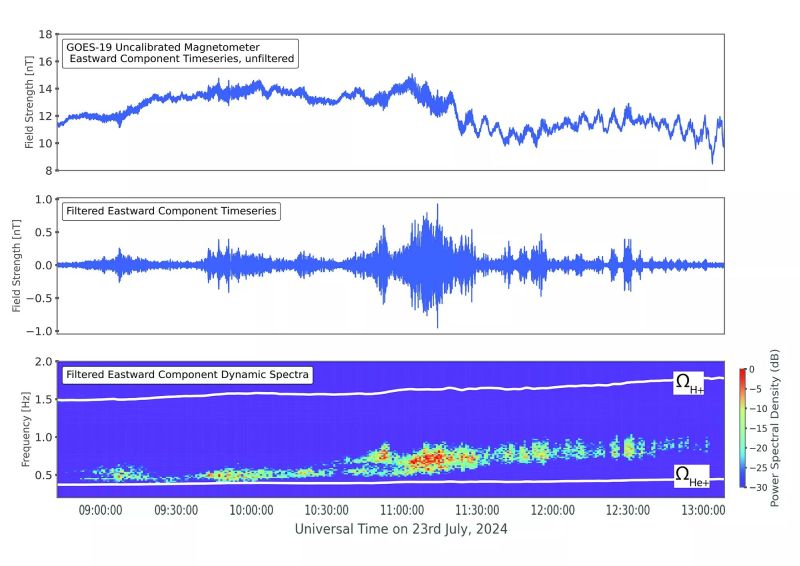
GOES-19, like its sister satellite GOES-18, carries an upgraded magnetometer instrument that provides improved measurements of Earth’s magnetic field over the magnetometers on earlier GOES-R series satellites.
The figure above shows data from the GOES-19 GMAG on July 23, 2024. The top and middle panels show the unfiltered and filtered Eastward component of the magnetic field, respectively. Data in the middle panel has been filtered to highlight a space weather phenomenon known as electromagnetic ion cyclotron (EMIC) waves. These waves play a significant role in controlling the levels of dangerous energetic particles that cause damage to satellites and harm astronauts. An important characteristic of these waves is their frequency, or how fast they oscillate up and down. This is shown in the bottom panel of the figure, where higher wave power levels are identified by the color bar. An example of an EMIC wave signal is shown in between the two white lines in the bottom panel, which indicate the frequencies that positively charged helium ions and protons circle the local magnetic field.
[ Back to Top ]
From NOAA Research
at https://research.noaa.gov/2024/07/22/noaa-tests-next-generation-wildfire-detection-and-warning-tools/
July 22, 2024
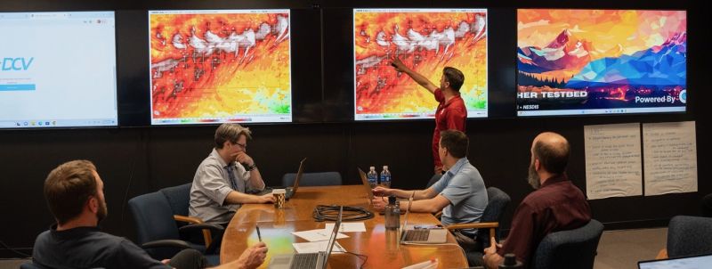
Two experimental tools that will speed fire detection and warning got a week-long test run in NOAA’s new Fire Weather Testbed in June during a series of hands-on simulations with National Weather Service fire weather forecasters, state wildfire managers, researchers, and social scientists.
The first, NOAA’s Next Generation Fire System, or NGFS, uses artificial intelligence to rapidly and autonomously identify fires from observations made by geostationary satellites. By quickly communicating information to forecasters and land managers, it reduces response time when a swift initial attack is most critical.
The second, the application of the Integrated Warning Team paradigm to wildfire, speeds the exchange of information between meteorologists and land managers and fire agencies to issue fire warnings through NWS channels for rapidly spreading wildfires threatening life and property.
"The tools and concepts we evaluated will turn our meteorologists into scientific first responders in partnership with fire, land and emergency agencies," said Todd Lindley, the NWS Science and Operations Officer for Norman, Oklahoma, who spearheaded the adaptation of the Integrated Warning Team concept to fire warnings. "These tools will help us provide timely and life-saving warnings of particularly dangerous wildfires."
[ Back to Top ]
From NOAA's National Environmental Satellite, Data, and Information Service
at https://www.nesdis.noaa.gov/news/geoxos-ocx-instrument-will-be-game-changer-satellite-ocean-observations
July 18, 2024
AAfter nearly 50 years of GOES satellites providing critical Earth-observing data and imagery, NOAA is working on its next generation series of advanced geostationary satellites – the Geostationary Extended Observations mission, or GeoXO.
GeoXO will host a payload of new instruments that will provide unprecedented information for addressing our changing planet and the evolving needs of NOAA’s data users.
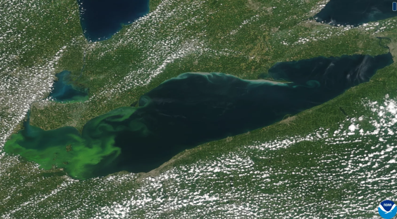
One of those instruments being developed by BAE Systems is the Ocean Color Instrument (OCX), which will provide fine-scale data about the U.S. coastal waters and the Great Lakes from geostationary orbit.
Current ocean color instruments on NOAA’s polar-orbiting satellites orbit around certain areas only once or twice a day. This makes them especially vulnerable to passing over a water body that is shrouded in clouds or reflecting "sun glint," both of which can obscure the data the satellites receive.
Geostationary satellites, however, orbit at the same speed that the planet rotates—allowing them to hover over the same part of the globe constantly. Not only does this reduce the cloud cover and sunglint issue, it allows them to continuously monitor a specific area to track both short-term and longer-term ocean and coastal ecosystem changes.
[ Back to Top ]


From NOAA Research
at https://research.noaa.gov/2024/06/13/a-class-of-ozone-depleting-chemicals-is-declining-thanks-to-the-montreal-protocol/
June 13, 2024
New research by a team including current and former NOAA-affiliated scientists has shown that atmospheric concentrations of a class of ozone-depleting chemicals used as refrigerants, foam blowing agents and solvents peaked in 2021 and are now beginning to decline as nations comply with restrictions called for by the Montreal Protocol.
The research, led by a scientist at the University of Bristol in England and published in Nature Climate Change, focused on a class of industrial chemicals called hydrochlorofluorocarbons (HCFCs). HCFCs were created as first-generation alternatives to more-damaging chlorofluorocarbons, or CFCs, which were responsible for creating the springtime hole in the ozone layer above Antarctica. HCFCs also deplete ozone and trap heat in the atmosphere, but to a lesser degree than the CFCs they replace.
Lead author Luke Western, Marie Curie Research Fellow at Bristol University’s School of Chemistry, said the results underscore the value of establishing and following international agreements like the Montreal Protocol on Substances that Deplete the Ozone Layer.
[ Back to Top ]
From NOAA"S National Centers for Environmental Information
at https://www.ncei.noaa.gov/news/super-marine-heatwaves-new-term-growing-concern
August 13, 2024
2023 was a record-breaking year. According to the Annual 2023 Global Climate Report, 2023 was the warmest year since global atmospheric temperature records began in 1850, at 1.18°C (2.12°F) above the 20th-century average of 13.9°C (57.0°F). Now, a new analysis led by NCEI scientists published in Geophysical Research Letters (GRL) shows that global mean sea surface temperatures also set a record high in 2023. The paper further indicates that these record-breaking temperatures were associated with extremely strong marine heatwaves that the authors dubbed super-marine heatwaves.
Sea surface temperature (SST) is the temperature of the uppermost layer of seawater, which typically means the top few meters. SST data are collected by satellite observations or by in situ observations from ships, drifting buoys, moored buoys, and more recently, Surface Autonomous Vehicles such as Saildrones. Monitoring changes in SST is essential for understanding and mitigating the impacts of climate change and other environmental stressors.
[ Back to Top ]
By Monika Luabeya, Lindsey Doerman, NASA Explore
at https://www.nasa.gov/image-article/saharan-dust-in-the-wind/
August 29, 2024
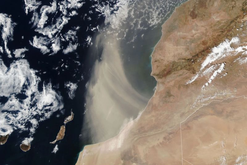
The Suomi NPP satellite acquired this image of a plume of Saharan dust as winds lofted it over the Atlantic Ocean on Aug. 24, 2024.
The Sahara Desert is Earth’s largest source of airborne dust, and the particles can travel for thousands of miles. From late spring to early fall, it is common for the dry, dusty Saharan Air Layer to carry the particles westward across the Atlantic Ocean high in the atmosphere. Saharan Air Layer activity subsides after mid-August, according to NOAA, making it less likely that the plume shown here is bound for a transoceanic journey. Instead, it arcs to the north after blowing out over the ocean. Earlier in the summer, however, several clouds of fine dust from the Sahara reached the United States, creating hazy skies over Texas.
Read more about Saharan dust and why it’s interesting to scientists.
See the original article at https://www.nasa.gov/image-article/saharan-dust-in-the-wind/.
[ Back to Top ]


By Rebecca Lindsey, Franz Phillip Tuchen, Sang-Ki Lee
Posted by Climate.gov
at https://www.climate.gov/news-features/event-tracker/four-things-know-about-possible-atlantic-nina
August 28, 2024
Earlier this month, we wrote about a pocket of cooler-than-average surface waters that had emerged near the equator in the eastern Atlantic in June and July. The localized cool spot was interesting because if it had continued at that strength through August, it would be classified as an Atlantic Niña — a natural pattern of warm-cool swings in the eastern equatorial Atlantic that affects seasonal climate in the region.
Our plan was to wait give the August data a chance to come in and be analyzed before doing a follow-up post in early or mid-September covering whether the event formed or fizzled, what the potential influences could be on seasonal temperature and precipitation in the region, as well as some background on what we know and don't know about why these events occur and whether human-caused climate change is expected to affect the pattern.
That post is still coming, but we are squeezing in a quick extra post because there has been a lot of interest in the event, as well as a bit of...let’s call it over-interpretation...in some corners of the internet (as well as the Climate.gov webmail inbox) that we want to tamp down if possible. In that pursuit, here are 4 things you should know about Atlantic Niñas and Niños.
[ Back to Top ]
From NOAA's Climate Program Office
at https://cpo.noaa.gov/combined-ocean-atmosphere-data-improves-complex-ocean-forecasts/
August 23, 2024
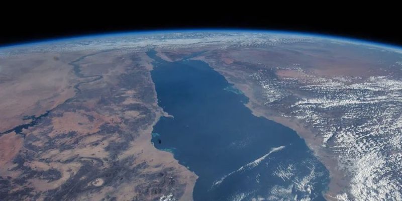
Predicting ocean conditions is crucial for managing environmental challenges and economic activities like shipping. A new study in Ocean Modeling found that combining data from both the ocean and atmosphere can lead to more accurate forecasts, even in complex environments like the Red Sea. This new approach could lead to more refined and reliable prediction systems, which would have environmental and economic benefits.
The researchers created simulations of different ocean and atmosphere conditions using a specialized computer model called the Scripps–KAUST Regional Integrated Prediction System (SKRIPS) that integrates both ocean and weather data from satellite and ship-based observations. The results show that SKRIPS provided better predictions than models that only used ocean data. The Climate Program Office’s Climate Variability & Predictability (CVP) program partially funded the authors of this study through multiple grants aimed at improving our understanding of processes in the tropical Pacific Ocean.
[ Back to Top ]


By John Uri, NASA Johnson Space Center
at https://www.nasa.gov/history/235-years-ago-herschel-discovers-saturns-moon-enceladus/
August 29, 2024
On Aug. 29, 1789, German-born British astronomer William Herschel observed a tiny bright dot orbiting around Saturn. His son later named the object Enceladus. Because of its distance from Earth and proximity to bright Saturn, for the next two centuries little remained known about Enceladus other than its size, orbital parameters, and that it held the honor as the most reflective body in the solar system. It took the Voyager flybys through the Saturn system in the early 1980s and especially the detailed observations between 2005 and 2015 by the Saturn orbiter Cassini to reveal Enceladus as a truly remarkable world, interacting with Saturn and its rings. Harboring a subsurface ocean of salty water, Enceladus may possibly be hospitable to some forms of life.
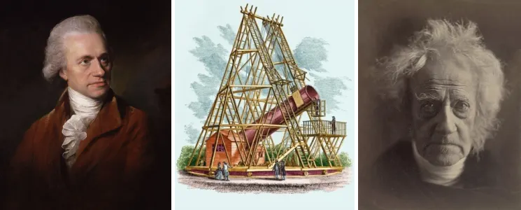
Herschel’s previous astronomical accomplishments include the discovery of Uranus in 1781 and two of its moons, Oberon and Titania, in 1787. He also catalogued numerous objects he termed nebulae, but remained frustrated by the limitations of telescopes of his age. He began to build ever larger instruments, finally building the world’s largest reflecting telescope of its time. At 40 feet long, and with a 49-inch diameter primary mirror weighing a ton, it looked impressive although its optical characteristics did not advance the field as much as he had hoped. Nevertheless, Herschel used this telescope to observe Saturn and its five known moons, looking for others. On Aug. 28, 1789, he observed a bright point orbiting the planet and believed he had discovered a sixth moon. On Sept. 17, he discovered a seventh moon orbiting the ringed planet. He did not name these moons, that task fell to his son John who believed Saturn’s moons should be named after the Titans of Greek mythology. He named the first moon Enceladus and the second Mimas.
[ Back to Top ]


Whether you are just starting a new school year, in middle of your school year, or on a break between terms, this is for you, the teacher.
SEA Lesson Plan Library with 40 lesson plans for grades K-12. All lesson modules are checked and updated every 1-2 years (last update June 2024). All address Next Generation Science Standards and most also address National Science Education Standards. Students actively participate in learning about aspects of satellite technology, related science concepts. They practice accessing, analyzing, and applying remote sensing data from geostationary and polar-orbiting environmental satellites operated by NASA, NOAA and the USGS. Additional resources are available for download where needed. The Library includes search tools and its own Analysis Toolbox. Visit https://SatEd.org to find a lesson for your students, all available at no charge.
Using Satellite in Education is an online guide for students and teachers. Step into the realm of man-made satellites and satellite-based remote sensing, how to access the data and use them to better comprehend our planet Earth and how to interact with it. Begin with basic information about environmental satellites and using remote sensing data. Follow with more in-depth looks at ways to access specific data, visualize and analyze them, then interpret and apply that knowledge to our Earth systems and human condition. Find applications for science, mathematics, engineering and technology, geography, and more. All delivered with descriptive texts, how-to-do-it videos, downloadable tutorial guides and information sheets, and links to applicable lesson plans and bounteous resources. All at no cost. Your exploration starts at https://SatEd.org.
Bring NASA into Your Classroom This Fall Through Virtual Experiences is an offering from NASA for K-12 students and teachers. Explore the universe this fall without leaving your classroom through live virtual engagements with NASA space and aviation experts. NASA has a great lineup of stellar virtual experiences to spark STEM excitement and connect students with the agency's missions, science, careers, and more. The virtual engagements are free to join and open to both formal and informal education groups. Visit https://www.nasa.gov/learning-resources/bring-nasa-into-your-classroom/.
Space to Learn. Here NASA launches learning to new heights with STEM resources that connect educators, students, parents and caregivers to the inspiring work at NASA. Kids and K-12 students can dig deeper into STEM topics and experience the thrill of exploration and discovery. For educators, NASA offers a wide array of unique experiences designed to engage K-12 students nationwide in the agency's missions, people, and resources. For colleges and universities, NASA leverages its unique missions and programs to enhance and increase the capability, diversity, and size of the nation's future STEM workforce. Connect today with topics like searching for STEM resources, exploring opportunities for students, connecting science for everyone, and discovering STEM careers at NASA. You can even sign-up for the NASA Express Newsletter. Visit https://www.nasa.gov/learning-resources/.
Back to School Bundles: NOAA Resource Kits for Your Classroom. Go back to school with NOAA! "We've curated NOAA resource kits for popular topics that are tailored to different grade levels. We hope that teachers, educators, and learners everywhere can use these kits in (or out!) of the classroom." Presented in five parts, the first introduces the structure, contents, resources, and use of each school bundle. Part 2 takes learners in grades K-2 into the ocean to learn about ecosystems. In Part 3, grades 3-5 learners find out all about clouds. Learners in grades 6-8 explore climate change and trends in Part 4. Part 5 takes students grades 9-12 into the complexities of food webs to help understand how energy flows in an ecosystem. Find NOAA School Bundles at https://www.noaa.gov/education/explainers/back-to-school-bundles-noaa-resource-kits-for-your-classroom.
Online Maps for Primary and Secondary Schools. Interactive maps make your school a better place. From promoting student engagement in the classroom and driving projects that get students involved in their communities to improving administration of your school and district, maps and data provide a deeper understanding of specific topics and the world at large. Learners of all ages build skills in data management and analysis while solving problems with geographic information system (GIS) technology. Our best problem-solving is done with a complete sense of the situation. Maps show us what was, what is, and what can be. From local to global, explore what-if scenarios and design alternative solutions. Check out https://www.esri.com/en-us/industries/k-12-education/overview today and get started.
ESRI K-12 Teacher Video Challenge is an opportunity for teachers to showcase their use of ArcGIS Online in classroom instruction for the change to be recognized. The teacher video challenge highlights the impressive ArcGIS Online projects created by teachers in the United States who teach kindergarten through 12th grade. After you've explored previous winners, consider nominating yourself. Click HERE for more information.
[ Back to Top ]


On October 22, 2012, Tropical Depression Eighteen formed in the Caribbean Sea. Six hours later it became Tropical Storm Sandy. Over the next ten days, Sandy moved northward, crossed Jamaica and Cuba, ran along the Bahamas, then turned northward to generally parallel the U.S. eastern seaboard while the storm center remained 200-400 miles offshore until October 29. On that date, Sandy made a left turn, increased its ground speed until in made landfall in New Jersey, then almost stalled about 100 miles inland. Sustained wind speeds at landfall were still at Category 1 hurricane level. Its cloud field covered all the northeast quadrant of the continental U.S. and much of eastern Canada. Called a superstorm by the news media, the extent of high winds, rainfall and snowfall for several days was unusually wide. Hurricane Sandy ranks second in destruction only to Hurricane Katrina. What did the meteorologists at the National Weather Service see that caused them to correctly forecast the storm's turn and destructive power? In this lesson learners investigate and compare characteristics of Hurricane Sandy with Hurricane Katrina using NOAA and NASA online access tools, ESRI's ArcGIS Online, and ImageJ software; then apply the same techniques to analysis of other storms.
| Grade Level: | 6-12 |
| Time Requirement: | 1-3 class periods |
| Prerequisites: | None |
| Relevant Disciplines: | Earth& Space Science, Physics, Physical Science |
[ Back to Top ]
Share your satellite-based lesson ideas with the teaching community.
Send us a full lesson plan, or simply suggest a lesson idea. If you found the idea online, please share the source as well. The lesson can be about anything that helps connect learners with satellite-based technology - any grade level K-12 - any STEM subject area or geography.
"Satellite-technology" includes any part of the science, math, engineering, or technology of satellites, rockets, and remote sensing instruments as well as the use of any environmental satellite data to explore questions related to aspects of global change and local impacts in the long term, short term, and catastrophic time frames. Of special interest are lessons providing opportunities for learners to inquire, experiment, and apply mathematics.
Perhaps you designed a lesson yourself - we will happily prepare it for future publication in More Lessons from the Sky and inclusion in the SEA Lesson Plan Library. Perhaps you found a worthy lesson plan published elsewhere - we swill do the research for possible inclusion in a lesson plan spotlight. In either case, you will receive full credit for developing and/or bringing the lesson to the attention of the teaching community. Don't forget to share your insights if you tried the lesson with students.
Please share your ideas at SEA.Newsletter@SatEd.org.
[ Back to Top ]
![]()
This edition of the SEA Newsletter was produced in HTML5.
It is best viewed with most recent updates of Firefox, Edge, Chrome, Opera, or Safari.
©Satellite Educators Association, Inc. (SEA) https://SatEd.org SEA.Newsletter@SatEd.org
Satellite Educators Association, Inc. is a 501(c)(3) non-profit educational organization.
The SEA Newsletter is published quarterly in March, June, September, and December.
The SEA Newsletter is published on-line and available at no cost.
SEA terms, conditions, policies, and contact information are detailed HERE.
Unless otherwise listed, all photo and image credits are the authors of the articles.
Any opinons expressed in this Newsletter are those of the authors
and not necessarily those of the Satellite Educators Association, Inc.
or any of its officers, members, or representatives.
Many SEA Newsletter items contain third-party links to sites not governed by Satellite
Educators Association, Inc. The viewer is cautioned to be aware of the terms of use and
privacy policies for those third-party sites.
![]()