

OUR VISION
The world's finest educators supporting science, technology, engineering, and math (STEM) learning for pre-kindergarten to post-graduate students using real-world applications from satellites and satellite data.
OUR MISSION
To enhance the education environment to excite students about science, technology, engineering, and math through space-based technology -- satellites and satellite data.

The Confessions of St. Augustine
Rex Warner, translator

Honesty is the rarest commodity in the 21st century. No one looks to the political class or journalists for truth these days. The average Joe seems to spend most of their time peddling a ludicrous, flawless Facebook version of their lives. The peer pressure of political correctness forgoes truth for the sake of groupthink. It seems that comedians and writers represent the last bastion of candour out there today.
Stewart Stafford

TABLE OF CONTENTS
Click a RED link to view article
IN MEMORIAM
CONFERENCES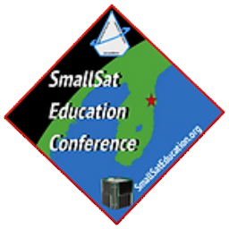
ASSOCIATION NEWS
PRESIDENT'S CORNER
JOHN'S JOURNEY
STEVE'S SPACE
SATELLITES
ACCESS
ANALYZE
APPLY
IN THE NEWS
FOR TEACHERS
MORE LESSONS FROM THE SKY

June 1, 2026
In just one month, the United States will celebrate its 250th birthday. The advancements in all STEM knowledge arenas during these two and a half centuries has been nothing short of astonishing! In this issue of the SEA Newsletter, SEA first remembers the human achievements of our late friend and colleague Ron Gird. Then our attention is turned to some of the current technological wonders involving satellites.
Top stories include the Artemis II Moon mission and Landsat data analysis and application. There is a lot going on as we continue to explore and learn about our planet Earth and stewardship.
The successful Artemis II mission took an astronaut team around the Moon and home again in April. The President's Corner discusses the significance of that mission and Steve's Space describes in detail the relevance of this Moon mission to crewed Martian missions in the future. NOAA explains how the Space Weather Prediction Center kept the astronauts safe from harmful radiation.
The Mars Rover Curiosity is drilling and analyzing rock samples on Mars giving us more information about the geologic composition of that planet. Back to Earth, the NISAR satellite (referenced in John's Journey) maps diverse agricultural fields in South Africa. NOAA has a new database providing access online to bathymetric data to map underwater terrain. For more than 60 years, Landsat satellites have provided continuous information about the changing landscape of the Earth's surface. Landsat satellites are highlighted in a NASA Earth Observatory article and the lesson plan in More Lessons from the Sky.
Weather is accented in articles about the predicted strong El Niño, the spread of West Nile disease, how forecasters work with fire crews, and the discovery of nanoparticles in the lower stratosphere.
Other new technologies explored are the Roman Space Telescope, how NASA's EMIT satellite finds and maps waste runoff from abandoned mines, and NOAA's new solar sail satellite.
SEA makes special announcements about (1) the SmallSat Education Conference and (2) the Annual SEA Members Meeting to be scheduled this summer.
SEA is pleased to offer the Summer 2026 issue of the SEA Newsletter. If questions or comments are appropriate, SEA welcomes constructive feedback at Contact Us and the SEA Forum.
A last note -- Four articles in this newsletter include NASA or NOAA videos from their respective YouTube libraries. When you play the video, Google (owner of YouTube) attempts to determine if you are a bot and may block the video. Google may require you to sign-in to your YouTube account or create one in order to view the video, or your browser may display a "secure connection failed" message. Use of a VPN (virtual private network) will most likely trigger Google's protocol. It is recommended that these videos be viewed without a VPN.
Enjoy!
--Editor

[ Back to Top ]

Ron Gird, our good friend, colleague, and an avid SEA supporter, passed away April 25, 2026. Input from Ron was a regular feature of the SEA Newsletter. He will be sorely missed. See SEA's memorial page for Ron HERE.
Here is a short video of Ron explaining how weather satellite imagery was used in forecasting the weather in 1983.
Then a special remembrance from Tom Wrublewski who served as GOES Technical Acquisition Manager at NOAA's National Satellite, Data, and Information Service. It is a story of Access, Analysis, and Application of satellite imagery and the part Ron played long before AI developed to a point of doing it for us.
My first encounter with Ron Gird was before he was working for NOAA. I am not sure if it was his idea or something that he was working on with others, but he was looking to get an Earth-from-space image created using visible wavelength data from Advanced Very High Resolution Radiometer (AVHRR) carried on NOAA Polar-Orbiting weather satellites. The image was to have no clouds in it for every location around the world. Some locations like mountain tops were often cloud covered so it was an ambitious, and no doubt tedious, process to find cloud free images for every location on the earth. Never mind the state-of-the-art efforts and software that were likely needed to assemble all those images into one picture back then. Stanley Schneider, former NOAA NESDIS Advanced Systems Planning Division Chief, recalled that Ron Gird could best be described as Promoter, Advocate, and Facilitator for this project. Whoever Ron worked with, they succeeded on April 15, 1990, after a year of work and the image became commercially available from the Tom Van Sant Geosphere Project. The image was placed on ceramic mugs, mouse pads, and other items which I sometimes purchased to thank people leaving or retiring from the NASA/NOAA Metsat and POES Projects. The image was sold for years at the NASA Goddard Space Flight Center visitor center. The Geosphere image was 8,640 pixels wide by 4,320 pixels high with 4km/pixel resolution.
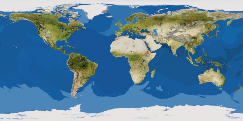
"The Earth from Space Image marks a milestone in cartographic history. It is the first satellite map of the Earth, showing the real world as it appears from space. The work required one year of effort on the world's most powerful graphics computers by Van Sant, technical director Lloyd Van Warren of Jet Propulsion Laboratory, and assisted by Jim Knighton and Leo Blume. Using multiple whole-Earth mosaics collected by Advanced Very High Resolution Radiometer (AVHRR) sensors on board TIROS-N (Television and InfraRed Observation Satellite Next generation) satellites, the composite was derived from over 2,000 images with a ground resolution of 4.6 km (2.9 mi). The project required ten months of software development and both interactive and non-interactive methods of creating the mosaics using a Stardent GS1000 Graphics Supercomputer – then amongst the most powerful machines of its type. The image was first published as the title page of the 1990 National Geographic World Atlas." --https://en.wikipedia.org/wiki/Tom_Van_Sant
"When the GeoSphere Image was completed, its data was transferred onto magnetic tape, loaded into the computer of a digital camera, and photographed directly. The image was enlarged, shaped into 36-equally sized gores, and printed to fit a 6-foot 4-inch diameter sphere, which Van Sant had already produced. The gores were then cut out and pasted onto the sphere, making the first GeoSphere Globe." --https://www.tomvansantgeosphere.org/the-geosphere-globe
There is a very interesting 12-minute video about the Geosphere Project and its evolution to the Earth Situation Rooms that were developed around the world. Watch the video at https://vimeo.com/50738196.
Later, applying similar technology, other cloudless whole-Earth images were developed. For example, on the large printed image that I purchased, 1 inch at the equator equals 726 miles. That's a resolution of 1km/pixel requiring 900 MB data set. Another example is the DMSP (Defense Meteorological Satellite Program) Operational Line Scanner low-light level channel image showing all the lights at night all around the world.

The Geosphere was truly a remarkable team accomplishment. I am at a loss to know what role Ron Gird played in making this all happen, but he was the first person that I know of to make an inquiry about obtaining the needed imagery from NOAA archives.
Tom Van Sant spoke at an early Satellites & Education Conference that Ron helped plan. Van Sant met with teachers at the conference to explore the possibility of utilizing weather satellite direct read-out imagery received in classrooms around the country to continually update the weather patterns displayed on the Geosphere. It was an interesting and enticing idea that proved to be impractical at the time.
More about Tom Van Sant and The Earth From Space project is HERE.
Today, NOAA's Science On a Sphere is the next generation of geosphere globes. It is a room-sized sphere educational tool to illustrate Earth System science to people of all ages. It has been installed in 195 exhibits in 27 countries and 34 states at some of the largest public-serving science centers and museums which are visited by over 60 million people annually.
Ron's service positively impacted so many lives. One is reminded of the proverb, "Give a man a fish you feed him for a day; teach a man to fish, you feed a village for a lifetime." Thank You, Ron!
See more about Ron Gird, his life and accomplishments HERE.
[ Back to Top ]

SmallSat Education Conference, Nov. 7-8, 2026, Kennedy Space Center
The 2026 SmallSat Education Conference will take place at the AMF Center for Space Education in the Kennedy Space Center-Visitor Center in Florida, November 7-8, 2026. "The SmallSat Education Conference provides hands-on training for educators and students, networking opportunities with industry experts, and insights from exhibitors and vendors. Managed by Aerospace and Innovation Academy, The Wolfpack CubeSat Development Team, and BLUECUBE Aerospace, the event engages attendees with CubeSats, ThinSats, and High-Altitude Balloon programs, offering authentic experiences to help bring space education to the classroom." (www.smallsateducation.org)
You are invited to meet Stanley O. Kennedy, Jr. and Carol Craig, this year's SmallSat Education Conference keynote speakers, at www.smallsateducation.org. Mr. Kennedy is a lifelong aerospace innovator who has contributed to the development of heavy-lift launch vehicles, upper stages, spacecraft, and ground systems for both government and commercial customers worldwide. Ms Craig is founder and CEO of both Sidus Space, Inc. and Craig Technologies providing engineering and technology support for commercial and government customers. She is a former U.S. Navy Flight Officer. Both eminently qualified speakers will bring a wealth of information to the educational community at this conference.
New this year is a special event on Friday, November 6, 2026: A Pre-conference Summit for Gifted, Dyslexic, & Neurodiverse Students & Educators Space Day.
The 2026 theme is "Skills that Launch: Workforce Readiness and SmallSats." The conference will feature four dynamic tracks although innovative experiences and ideas beyond these themes are welcome. Abstracts for proposed presentations are due September 15, 2026. Abstracts can be submitted online at www.smallsateducation.org.
Conference registration online will open later this year. The program of presentations will be posted mid-October.
If you remember the Satellites & Education Conference, this newer SmallSat Education Conference will surprise and impress with its usefulness. If you never heard of the Satellites & Education Conference, the SmallSat Education Conference is your best introduction to the important ways satellite technologies interface with K-16 education.
Watch the SEA Conferences page for more information as it becomes available.
[ Back to Top ]

The annual meeting of Satellite Educators Association members is scheduled this summer. The Executive Committee is finalizing the date and setting the agenda. The online meeting will be offered via ZOOM. The exact date and time of the meeting and log in instructions will be emailed to members well before the meeting date. SEA wants to hear from you -- join or update your membership before the meeting to insure you have voice and vote.
The annual meeting agenda will include the standard reports on the state of the Association. Of special interest will be a vote for continued support for the SmallSat Education Conference scheduled for November 7-8, 2026 at Kennedy Space Center in Florida. More information about the conference is HERE.
While lapsed and non-members are welcome to visit the annual meeting, only Active Members (those with dues paid) have voice and vote. To renew your membership, please visit Member Services at https://SatEd.org. To join as a new member, please visit Join Us at https://SatEd.org. In both cases, just follow the on-screen instructions to update or create your profile and pay $20 annual dues. More details about membership can be found in the Terms and Conditions.
See Why Should I Join or Renew My SEA Membership below to learn what your SEA dues support.
Don't miss the annual SEA Members Meeting this summer. SEA values your voice. Join or update your dues and be part of the conversation!
[ Back to Top ]
Is it that time of year again already? Time to renew my SEA membership? Or, join SEA for the first time?
If you are new to the Satellite Educators Association, WELCOME! If you are a current or lapsed member, this is the best time to renew. SEA membership expires at the end of July each year. Was there mention of a "membership deal" in the last newsletter?
As published in SEA's "fine print" (Terms & Conditions), membership in the Satellite Educators Association runs from August 1 to July 31 and is renewable each year. An annual membership is just $20. That amount has not increased for more than three decades. The amount itself is a deal!
But SEA offers another deal. If a new, current or lapsed member pays dues for the 2025-2026 membership year before March 1, 2026, the membership expiration date will be July 31, 2026. No need to worry - March 1 was three months ago. If a member pays dues for the 2025-2026 membership year after March 1, 2026, the expiration date will be July 31, 2027 -- that's a year for free.
What does my SEA membership support? In a time of nay-sayers, climate-change denyers, and conspiracy theorists, the Satellite Educators Association focuses on four primary activities:
Your current membership status is one of these:
To renew an Active or Inactive membership, Log into SEA Member Services here or on the SEA home page to check your membership status and pay dues with either a credit card online or mailing a check. Alternatively, you can check your membership status at Join Us.
To join the Satellite Educators Association as a new member, visit Join Us here or on the SEA home page.
[ Back to Top ]


By Simon Cracknell, President, Satellite Educators Association; Classroom Teacher and Department Head, United Kingdom
For more than 100 years, we have looked to the Moon as a symbol of exploration and mystery. After the Apollo era, human missions to the Moon stopped, leaving many questions unanswered. Now, led by NASA and supported by international partners and private companies, Artemis aims not only to return humans to the Moon but also prepare for future missions deeper into space.
The importance of Artemis is much more than repeating the achievements of the past. The programme has scientific, technological and economic significance that could shape the future of humanity for decades to come.
One of the most important aspects of Artemis is that it will return astronauts to the Moon for the first time since Apollo 17 in 1972. Unlike the Apollo missions, which focused mainly on short visits and national prestige during the Cold War, Artemis is designed to establish a long-term human presence on and around the Moon.
This means building sustainable systems, including lunar habitats, advanced spacecraft, and support systems. These developments are intended to allow astronauts to stay on the Moon for longer periods and eventually support regular missions rather than isolated expeditions. The programme therefore marks a major shift in human space exploration from temporary exploration to long-term settlement and operation beyond Earth.
Another major reason Artemis is so important is that it serves as preparation for future human missions to Mars. Sending astronauts to Mars is one of the greatest challenges in modern science and engineering. The journey would take many months, astronauts would need to survive far from Earth, and communication delays would make missions much more difficult.
The Moon provides an ideal testing ground for these challenges because it is relatively close to Earth while still offering a harsh space environment. Through Artemis, scientists and engineers can test life-support systems, space habitats, advanced robotics, and methods of using local resources. For example, researchers are interested in extracting water ice from the Moon’s surface. Water could provide drinking supplies, oxygen for breathing, and even hydrogen fuel for rockets. If such technologies work successfully on the Moon, they may eventually make long-distance missions to Mars possible.

Artemis is an international effort involving many countries and organisations, including the U.S. National Aeronautics and Space Administration (NASA), the European Space Agency (ESA), the Japan Aerospace Exploration Agency, and the Canadian Space Agency. This cooperation is important because modern space exploration is extremely expensive and technologically complex. By working together, countries can share expertise, reduce costs, and strengthen diplomatic relationships, which, in this fractious world, is needed more than ever.
The programme may also help establish future rules for peaceful cooperation in space. As more nations and companies become active beyond Earth, agreements about resources, exploration rights, and safety will become increasingly important. Artemis could therefore influence how humanity behaves in space in the future.
In conclusion, the Artemis programme represents a renewed effort to explore beyond the moon, but the benefits associated with it in the long term could help society in ways we cannot yet imagine.
[ Back to Top ]


By John D. Moore, Executive Director, Institute for Earth Observations at Palmyra Cove, New Jersey
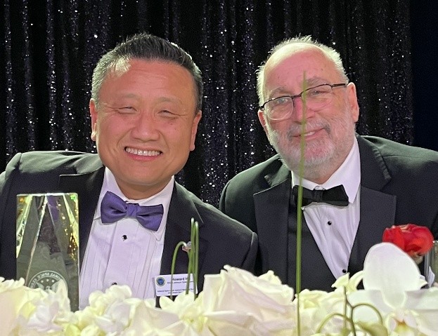
On March 13, I was honored to be recognized as the 2026 recipient of the National Space Club and Foundation Christa McAuliffe Space Educator Award. It was an extraordinary event attended by more than 2,000 individuals from across the aerospace community, including many of the nation’s leading space professionals and industry leaders.
One of the highlights of the evening was the opportunity to sit next to Howard Hu, Program Manager for the Orion spacecraft program. During our conversation, he passionately discussed the importance of preparing the next generation of the aerospace workforce and emphasized the growing national need for educational pathways that connect students to future aerospace careers. He graciously invited me to visit NASA Johnson Space Center to explore the Orion simulators and spacecraft capsule. I greatly look forward to that visit and to continuing discussions about Career and Technical Education (CTE) pathways focused on aerospace and geospatial technologies.
Planning is currently underway for the 2026 SmallSat Education Conference (https://www.smallsateducation.org/). I am working with Kevin Simmons to help develop a new conference track focused on Geospatial Intelligence (GEOINT), including satellite imagery, Earth observation data, remote sensing, and GIS applications. These topics strongly align with the long-standing history and mission of the Satellite Educators Association.
The Satellite Educators Association is proud to be a major sponsor of the SmallSat Education Conference since 2023.
To date, much of the conference emphasis has centered on precollege SmallSat engineering, design, and mission-based activities. The proposed GEOINT-focused track expands these efforts by connecting student-built and educational satellite investigations with authentic applications involving satellite imagery, Earth observation data, remote sensing, and GIS technologies. This approach broadens participation by demonstrating how teachers and students can engage in workforce-relevant investigations tied to emerging operational needs in Earth observation, geospatial intelligence, and future satellite mission applications using freely available satellite data and tools.
These activities support nationally important workplace readiness skills while also supporting NGSS (Next Generation Science Standards)-aligned classroom implementation, allowing educators to incorporate them into existing programs immediately.
The GLOBE Program Implementation Office recently released information regarding the future direction of the program as it celebrates its 31st anniversary. Announced on Earth Day, the program will continue under a new home within NASA as part of the crowdsourcing portfolio within the Enabling Capabilities Program.
This transition represents an exciting new chapter for GLOBE because it will intentionally connect educational activities to NASA’s major Earth observation missions, including PACE (Plankton, Aerosol, Cloud, ocean Ecosystem), NISAR (NASA-ISRO Synthetic Aperture Radar), and TEMPO (Tropospheric Emissions: Monitoring of Pollution). The crowdsourcing connection will create expanded opportunities for environmental data collection that both support scientific research and provide meaningful, actionable information back to participating communities.
This development is especially exciting because it strengthens the connections between GLOBE scientific protocols and satellite-based Earth observations. In my opinion, this integration is long overdue and represents an important step forward for educators and students alike. The GLOBE Program continues to be supported by NASA, National Oceanic and Atmospheric Administration (NOAA), National Science Foundation (NSF), and the United States Department of State.
To all GLOBE teachers around the world who may be wondering where to begin, I encourage you to explore More Lessons from the Sky.
Remember -- you can teach anything with satellites.
Stay safe … stay well!
For now, I'm John...and this is my journey.
[ Back to Top ]


By Steve Mills, Retired Systems Engineering Scientist; owner and Chief Engineer of Polymath Geo
In my last column I promised to discuss the "history of plans for crewed missions to Mars, and discuss the obstacles to such a mission." However, since I wrote that column there has been a major milestone in crewed space missions, the success of Artemis II. Although this was not a mission to Mars, I will discuss how this Lunar mission is relevant to any future crewed Martian missions.
Artemis II mission aboard the Orion Spacecraft was the first mission with a crew to go beyond the Earth’s gravity since Apollo 17 in 1972. Let me explain how significant that really is. When we hear about astronauts on the International Space Station (ISS) we may think that they have left the Earth, and in a sense that is true because they are beyond the Earth’s atmosphere. But actually, they are in Low Earth Orbit (LEO), and for the ISS this is about 400 km (249 mi) from the surface of the Earth. Though they have left the Earth’s atmosphere, the Earth’s gravity in LEO is almost as strong as it is on the ground. The reason that astronauts on the ISS appear to be weightless is not because there is no gravity there, but rather, because the centrifugal force of the orbit exactly balances the Earth’s gravity.

The takeaway from most news reports about Artemis II is that it was the first crewed flight to the Moon since 1972. Indeed, it was. In my mind, however, the fact that this manned spacecraft actual left LEO was even more significant. All the crewed space missions from 1973 to 2025, a period of 53 years, were never more than a few hundred kilometers above the Earth. The first US space station, Skylab, had an altitude of about 440 km (273 mi), and the Space Shuttle had orbits from 200 to 600 km (124 to 373 mi) altitude. Mir, the longest lasting Soviet/Russian space station, had an altitude of about 370 km (230 mi).
By comparison with ISS, Artemis II reached a distance of 406,771 km (252,756 mi) from the Earth. That is one thousand times farther from the Earth than the astronauts on the ISS. To get a sense of this, Boston, MA is 440 km from Washington DC. By comparison, the distance Artemis II traveled from the Earth is equivalent to ten times around the Earth.
There are good reasons for all these LEO missions. For one, it takes much less energy to get to LEO then to go beyond Earth’s gravity. Also, for missions with a human crew, if something goes wrong in space, for example, a health emergency, the astronauts can quickly return to Earth in as little as a few hours. So, if the purpose is for humans to perform experiments in space, why go any further than LEO?
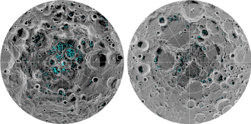
Since 2008 there has grown a renewed interest in returning to the Moon. In that year a NASA instrument on the Indian Chandrayaan-1 probe detected water in the Shackleton Crater near the lunar south pole. In 2009 another mission confirmed the discovery. There is now a real possibility that deep within these craters near the lunar poles there are large quantities of permanently frozen water. If, indeed, this is true, there is now at least the possibility of a sustained human presence on the Moon. Water is, of course, crucial for human life, but also it can be converted into rocket fuel using solar energy. Between now and 2030 there are over 80 announced missions to the Moon, in what National Geographic writer Charles Fishman calls "The Great Moon Rush." Artemis II is the most expensive and ambitious part of that "Moon Rush," but many of these other missions to the Moon are being financed by venture capital rather than government funding.
Artemis III is the next scheduled NASA crewed lunar mission and is planned for 2027. Its primary purpose will be to "test integrated operations between the Orion spacecraft and one or both commercial lunar landers from SpaceX and Blue Origin respectively." This statement by NASA should probably be seen as a declaration of a contest between SpaceX and Blue Origin. As of this writing neither the SpaceX nor the Blue Origin lunar landers have been flight tested. Nevertheless, Artemis IV is scheduled to land a crew on the Moon in early 2028.
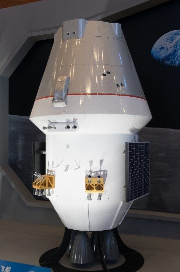
The Chinese government have their own plans for landing a crew on the Moon by 2029 or 2030. Similar to NASA’s Artemis I Mission, China will test Mengzhou 1 spacecraft in an uncrewed mission to the Moon in September 2026. If this test is successful and the Artemis program experiences delays, there is a real chance of a neck-and-neck Space Race reminiscent of the 1960's.
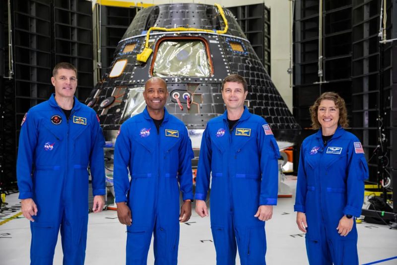
Most readers have probably seen numerous news reports and social media posts about Artemis II, but it is nevertheless worth summarizing the highlights. The crew of four was remarkable in that it included the first woman, the first person of color, the first Canadian, and the oldest person to go on a lunar mission. It launched on April 1, 2026 at 22:35:12 UTC. The Apollo missions all began with the spacecraft immediately entering a LEO, but Artemis II is noteworthy in that it did not. Instead, it entered a highly elliptical orbit, then transitioned to a LEO for less than one orbit, and then powered its rockets to a high earth orbit (HEO) one hour and 48 minutes after the launch. This is noteworthy in that it is the first time a crewed moon mission chose a high earth orbit rather than an LEO for its "park" position. The spacecraft remained in this orbit for approximately 24 hours, during which time the crew conducted tests of the system before making the decision of whether to go to the Moon or return to Earth. They also conducted maneuvers to test how well the Orion/ESM spacecraft can be docked with other spacecraft (as will be necessary on future Artemis missions). ESM is the European Service Module designed for the Artemis program by Airbus Defence & Space.
These tests were all considered successful, and the decision was made to proceed to the Moon on flight day 2. Integrity (the name given to the Orion spacecraft used in the Artemis II program) performed a 5-minute, 49-second burn using the ESM's main engine. This was the only use of the main engine during the mission; subsequent maneuvers were carried out by the eight smaller secondary engines. The spacecraft was on a free-return trajectory, meaning that before and after the lunar flyby no more rocket power was needed for it to return to Earth. The small secondary engines are for fine course corrections, and these were only used once. For the next four days Integrity continued on its course.
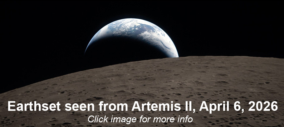
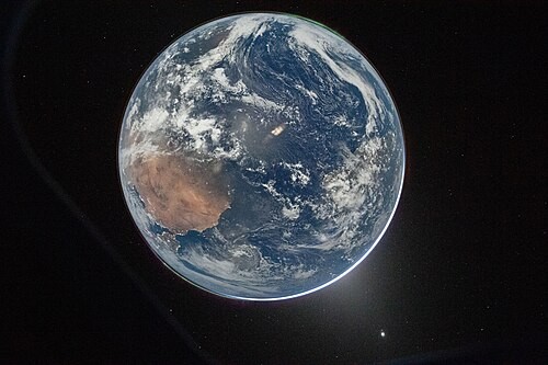
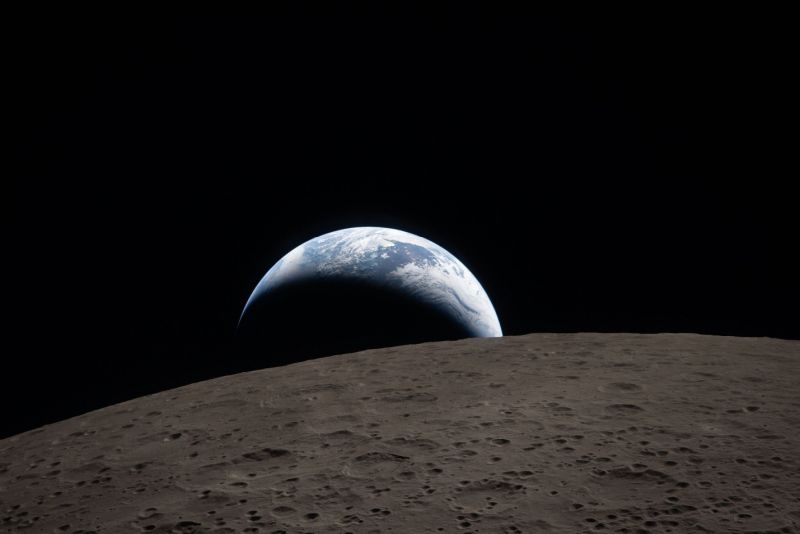
It is from this period that many of the pictures you have probably seen were taken. The photo below shows an image of the Earth by Artemis II Commander Reid Wiseman on April 3, 2026. It is of the Earth lit entirely lit by moonlight. North is at the bottom of the picture. If you look carefully, parts of Europe, Africa, the Atlantic Ocean and South America can be seen. Electric lights are clearly visible on land, and two auroras (top right and bottom left) and zodiacal light (bottom right) is visible as the Earth eclipses the Sun.
Probably the most impactful photo taken that shows Earthset during the Artemis II crew's flyby of the Moon on flight day 6. This was taken by astronaut Christina Koch aboard Integrity. Many who have seen the photo have expressed that it was emotionally impactful. For me it is reminiscent of the pictures of an Earthrise that were taken on Christmas Eve 1968 on Apollo 8.
The Integrity achieved its record for being the furthest humans have ever travel from Earth on April 6, 2026 at 7:02 p.m. EDT. After that it would take another 4 days to return to Earth. Splashdown was at April 10, 8:07:27 p.m.
The mission was almost a complete success. All systems passed their tests and the astronauts returned safely. We should note that the purpose of Artemis II was not to take cool or inspiring photos. An uncrewed spacecraft could have taken these same photos at perhaps one hundredth the cost. Artemis I was an uncrewed mission and it did test all the systems on the Artemis mission.
The main purpose of Artemis II was, rather, to monitor the biological response of the astronauts. Realize that it has been over fifty years since humans have traveled deep into space. This is a more hostile radiation environment than is typically encountered on LEO spacecraft. Medical researchers now have much better instruments to evaluate astronauts’ health. While Integrity was on its free-return trajectory, the crew did not have much to do, so they spent much of their time on exercise machines so that Earth-bound doctors could evaluate their response. This data will make all deep-space missions safer. These four astronauts took a risk so that future astronauts may be safer, and they should be congratulated for that.
References
[ Back to Top ]


By Ashley Balzer, Lead science writer for NASA's Nancy Grace Roman Space Telescope
at https://www.nasa.gov/missions/roman-space-telescope/nasas-roman-space-telescope-primary-mirror-gets-last-look/
May 29, 2026
Engineers at NASA’s Goddard Space Flight Center in Greenbelt, Maryland, have completed their final inspection of a key element for the agency’s Nancy Grace Roman Space Telescope: the primary mirror. This 7.9-foot (2.4-meter) mirror will collect and focus light from cosmic objects near and far, helping Roman capture stunning panoramas of space.
Ashley Balzer has more information about the Roman Space Telescope: click Read more HERE, and scroll to the bottom of the page to find links to additional articles.
[ Back to Top ]
From NOAA's National Environmental Satellite, Data, and Information Service
at https://www.nesdis.noaa.gov/news/one-year-of-goes-19-goes-east
April 7, 2026
It’s been one year since NOAA’s latest geostationary satellite, GOES-19, entered service as GOES East. Since then, it has provided critical data for high-impact events across the country.
[ Back to Top ]
By Ross Walter and Madeleine, Lansat Project Science Support, U.S. Geologic Survey
at https://science.nasa.gov/earth/earth-observatory/a-full-moon-checkup/
May 4, 2026
In April 2026, NASA's Artemis program took humanity back to the Moon, providing a new look at Earth’s only natural satellite. As the world celebrates the return of Artemis II’s four astronauts, the lunar surface continues to play a critical role in missions much closer to Earth.
Since 1972, the NASA/USGS Landsat program has captured the longest continuous record of Earth’s land surface, collecting images that track everything from crop health to glacial change. But with such a long data record, how can scientists trust that images acquired today can be accurately compared to those from days, years, or even decades ago? They look to the Moon.
Unlike Earth, with its constantly changing weather, seasons, and landscape, the Moon is remarkably stable. With no atmosphere and virtually no surface changes, the Moon reflects sunlight in a predictable, consistent way. This stability gives engineers a reference to fine-tune Landsat’s instruments and be confident that the data are accurate.
[ Back to Top ]
From NOAA's National Environmental Satellite, Data, and Information Service
at https://www.nesdis.noaa.gov/news/noaa-glides-the-future-solar-sail-technology
May 4, 2026
NOAA, in partnership with NASA and private industry, is developing a state-of-the-art solar sail that uses sunlight for propulsion to position space weather instruments closer to the sun.
Solar sail technology allows a spacecraft attached to the sail to move using sunlight alone. Much like how the wind can propel a sailboat, light from the sun can essentially "push" a spacecraft equipped with a reflective solar sail.
Sunlight is composed of particles called photons. When photons strike and bounce off the sail, they transfer momentum, gradually accelerating the spacecraft. This eliminates the need for rocket propellant and enables the spacecraft to travel indefinitely.
The solar sail membrane can be packed inside a space roughly the size of a microwave oven during launch. Once in space, lightweight carbon fiber booms unroll from the spacecraft to form rigid tubes that support the ultra-thin reflective sail. When fully deployed, the sail structure forms a square measuring more than 133 by 133 feet. By adjusting the sail’s angle relative to the sun, the spacecraft can change its position.
[ Back to Top ]


From NOAA's National Centers for Environmental Information
at https://www.ncei.noaa.gov/news/explore-sea-floor-ncei-modernized-portal
April 22, 2026
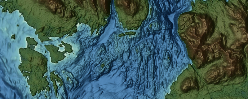
NOAA's National Centers for Environmental Information (NCEI) is excited to announce a big upgrade to the Bathymetric Data Map Viewer. The updated viewer is more responsive and provides a better mobile experience. NCEI scientists have also added more powerful search/filtering capabilities, and improved accessibility for users.
Bathymetric data is the mapping of underwater terrain and measurement of water depth, and is essential information for scientists in a wide range of fields. Bathymetric data is used to create nautical charts, which are crucial to large ships and maritime transportation so they are aware of water depth and potential underwater hazards. This data also aids in the study of changing coastline erosion, and even helps scientists study bottom-dwelling organisms and how they live, feed and breed. By updating the Bathymetric Data Map Viewer, NCEI is providing better access to the most accurate, up-to-date, bathymetric data for scientists around the world.
[ Back to Top ]
From NOAA Research
at https://research.noaa.gov/stratospheric-nanoparticles-surprising-abundance-is-a-game-changer/
January 26, 2026
A previously unrecognized but widespread class of ultrafine aerosol particles high in Earth’s atmosphere identified by researchers with NOAA’s Chemical Sciences Laboratory (CSL) has revealed a significant gap in scientists' understanding of a key region in the atmosphere.
The tiny particles captured during high-altitude research flights are roughly 100 times smaller than a dust particle. They were found to be surprisingly abundant in the lowest parts of the stratosphere, accounting for as much as 90% of the total aerosol surface area.
"These particles have been mostly invisible to us until now," said lead author Ming Lyu, a researcher with the Cooperative Institute for Research In Environmental Science who is affiliated with CSL. "Most instruments and satellites miss them because they are just too small, but they are really abundant and so, as a whole, they can have a big impact."
[ Back to Top ]


By Rachel Barry, NASA
at https://science.nasa.gov/science-research/astromaterials/nasa-uses-mineralogical-marker-to-understand-ancient-martian-climate/
May 28, 2026
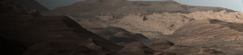
While NASA imagery has shown evidence of ancient rivers and lakes on Mars that transitioned to dry dunes, uncertainty remains over the timing of the environmental changes that may have contributed to these shifts.
Now, data collected by NASA’s Curiosity rover has revealed that individual crystals in the iron oxide hematite can be used as a mineralogical marker of changes to Mars' ancient climate. Because the shape and structure of these crystallites reflect the conditions – such as temperature and water presence – under which they were formed, they can serve as an indicator of when these changes occurred.
Scientists studied 20 samples collected by Curiosity across various elevations throughout Gale Crater for a paper published Thursday in Science. Gale Crater’s walls reveal Mars' environmental history layer by layer, with deeper elevations capturing its earliest years. The team analyzed data from the rover’s Chemistry and Minerology (CheMin) instrument and discovered that hematite showed different crystallite sizes at different elevations. They also discovered that goethite, a mineral that typically forms alongside hematite, was absent in samples from lower elevations but still present in samples from higher elevations. This suggests that warm groundwater might have remained for up to 4.7 million years in the deepest layers of Gale Crater and that during much of this time, these long-lived aquifers could have been potentially habitable.
[ Back to Top ]
From NASA Explore, Image of the Day May 28, 2026
at https://science.nasa.gov/earth/earth-observatory/a-shift-in-whats-shaping-u-s-landscapes/
January 14, 2026
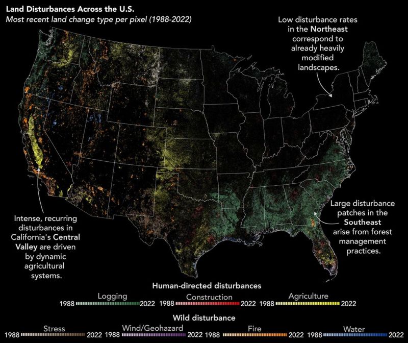
The land is always changing, sometimes by human hands: cities are built, farms expanded, and forests logged. Other changes lie mostly outside people’s control: wildfires burn through communities, and hurricanes reshape coastlines. For most of the past four decades, observations from the Landsat satellite record show that humans have dominated changes to the U.S. landscape. Recent research revealed a shift in that trend, suggesting that disasters might be catching up.
In a NASA-funded study published in Nature Geoscience, scientists analyzed nearly 35 years of data from NASA/USGS Landsat satellites to better understand what has been shaping the continental U.S. landscape. The researchers, led by former Landsat science team member Zhe Zhu, found that "human-directed disturbances" like logging, agricultural expansion, and construction have declined, while "wild disturbances" like wildfires and hurricanes—disasters that can be influenced by human activity but are not controlled by people—have risen in frequency and intensity.
[ Back to Top ]
From NOAA National Ocean Service
at https://oceanservice.noaa.gov/news/may26/el-nino-flooding.html
May 15, 2026
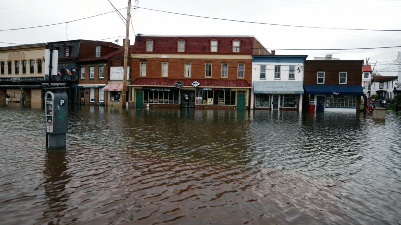
NOAA’s National Weather Service is predicting El Niño is likely to emerge by July 2026 and continue through the winter, and for many locations in the U.S. this could mean more high tide flooding.
To understand why more flooding is expected, it helps to understand what El Niño is and what it does. El Niño (and its counterpart, La Niña) are the warm and cool phases of a natural climate pattern across the tropical Pacific known as the El Niño-Southern Oscillation, often referred to as "ENSO." The pattern shifts back and forth between the cooler and warmer phases every two to seven years. There’s also a phase in between, ENSO Neutral, when sea surface temperatures are generally close to average. This neutral phase can last for months or years.
[ Back to Top ]


From NOAA National Environmental Satellite, Data, and Information Service
at https://www.nesdis.noaa.gov/news/artemis-ii-returns-how-noaa-helped-protect-astronauts-throughout-10-day-mission
April 13, 2026
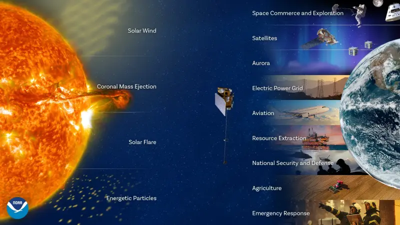
NASA’s Artemis II astronauts safely returned to Earth on April 10 after completing a 10-day journey beyond our planet's protective magnetic shield. The trip spanned roughly 685,000 miles, marking the first crewed mission around the moon in more than five decades. While the world watched the launch and splashdown, NOAA space weather forecasters were watching something else: the sun.
[ Back to Top ]
By Dana Chadwick and Katie Jepson, NASA Scientific Visualization Studio
at https://svs.gsfc.nasa.gov/15042
May 21, 2026
[ Back to Top ]
From NOAA News & Features
at https://www.noaa.gov/multimedia/photos-images/multimedia-story-forecasters-chart-weather-battlefield-for-fire-crews
April 9, 2026
Meet NOAA’s incident meteorologists (IMETS). These specially trained meteorologists with NOAA’s National Weather Service are dispatched to incident command centers and posts at the request of emergency managers. More than 50,000 wildfires occurred in the U.S. in 2025 alone, taking with them more than four million acres of land and destroying homes and sometimes whole communities. So far in 2026, more than 17,000 wildfires have occurred — including Nebraska’s record-breaking Morrill Fire — and more than 1 million acres have burned.
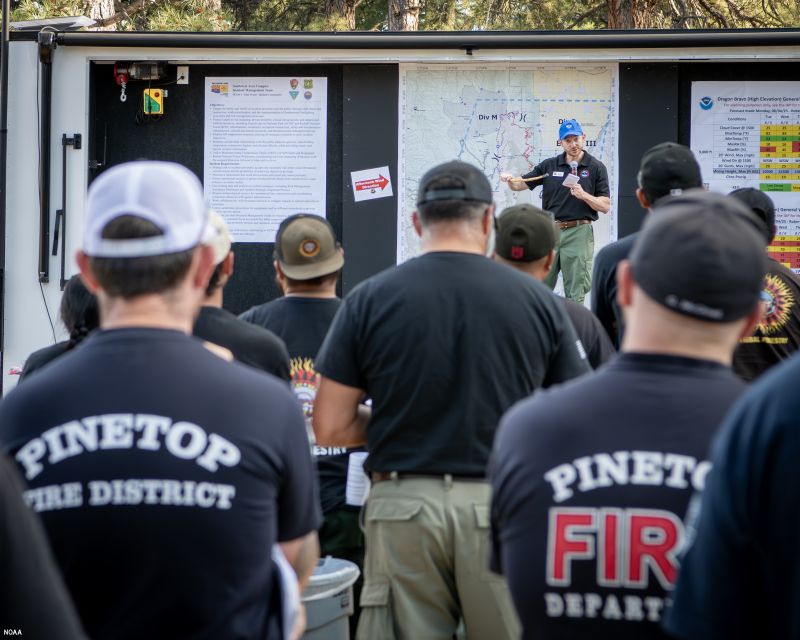
Dozens of IMETS are trained and ready to deploy to the front lines of wildfires to help keep fire crews and first responders safe during wildfire incidents in the months ahead.
Looking back to 2025, NOAA IMETs completed 141 missions including two major wildfires in August 2025 alone: IMETs served on the frontlines of the Dragon Bravo wildfire in Grand Canyon National Park, Arizona, and the Gifford wildfire in Los Padres National Forest, Solvang, California. Go behind the scenes to see just what it takes to work a major fire weather event...
[ Back to Top ]


From NOAA Research
at https://research.noaa.gov/noaa-research-offers-roadmap-to-improve-west-nile-forecasting-and-prevention/
May 12, 2026
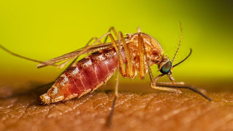
A new technique for forecasting West Nile virus based on NOAA weather data is the first of its kind to successfully predict caseloads of the most common and deadliest mosquito-borne disease in the nation.
Since the first cases were detected in New York in 1999, West Nile Virus has caused over 30,000 cases of severe illness and nearly 3,000 deaths in the U.S. There is still no human vaccine or effective treatment for the disease. A method for developing skilled predictions of where seasonal outbreaks could occur had not been identified until now.
[ Back to Top ]
From NOAA News & Features
at https://www.noaa.gov/news-release/noaa-predicts-below-normal-2026-atlantic-hurricane-season
May 21, 2026
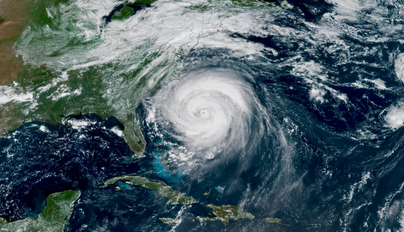
Forecasters with NOAA’s National Weather Service are predicting a below-normal hurricane season for the Atlantic basin this year. NOAA’s outlook for the 2026 Atlantic hurricane season, which runs June 1 to November 30, predicts a 35% chance of a near-normal season, a 10% chance of an above-normal season, and a 55% chance of a below-normal season.
[ Back to Top ]
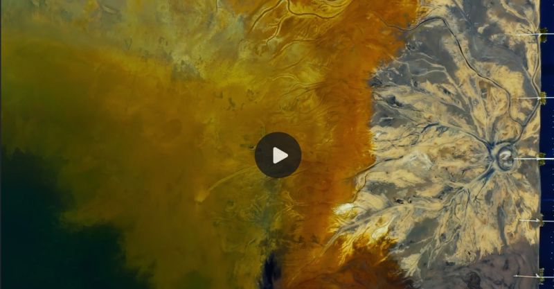
By Kathryn Hansen
at https://science.nasa.gov/earth/earth-observatory/painting-the-growing-season-in-the-maize-triangle/
May 28, 2026
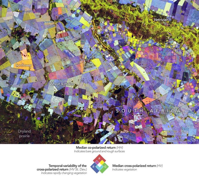
Along the Vetrivier (Vet River) in South Africa, a patchwork of circular and rectangular fields spreads across what is otherwise a semi-arid part of the Free State province. The water brings life to an array of crops, contributing to the agricultural productivity of the wider Maize Triangle.
The agricultural area shown in this image lies about 110 kilometers (70 miles) north of Bloemfontein. The scene is reminiscent of a modern abstract painting. Colorful circles mingle with straight-edged fields in combinations of red, green, and blue. But each color carries physical meaning, providing clues about crop types and revealing how they changed over the course of the Southern Hemisphere’s growing season.
[ Back to Top ]
From NOAA Climate Program Office
at https://cpo.noaa.gov/new-research-offers-insights-into-why-climate-models-often-get-spring-el-nino-forecasts-wrong/
March 21, 2026
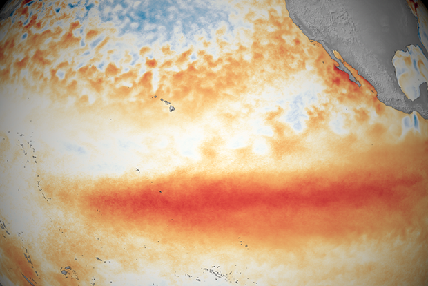
El Niño events have sweeping impacts on global weather, agriculture, and economies, so getting the forecast right matters. A new study published in npj climate and atmospheric science highlights a persistent blind spot: the overconfidence of climate models when predicting El Niño from March through May, a historically tricky time known as the “spring predictability barrier.” Researchers found that while models often issue high-confidence El Niño forecasts in spring, they frequently fail to deliver. The authors, Aaron Levine of the University of Washington and the NOAA Climate Prediction Center's Michelle L'Heureux and Caihong Wen found that the problem is that these models lean too heavily on tropical Pacific signals. The models can miss key influences from outside the tropics, leading to inaccurate forecasts that can leave decision-makers unprepared.
[ Back to Top ]


SEA Newsletter Staff
June 1, 2026
Here are some ideas of lessons and short- and long-term projects worthy of your classroom. Check them out here. Discover something that fits with your curriculum. Enjoy engaging your students in doing science and preparing career pathways.
[ Back to Top ]


From the petroglyphs of ancient societies to the stunning views of our planet from space, humans have endeavored to visualize and accurately map our world. As early geographers recorded the experiences from travelers and merchants, they created lists of places and geographic features. To spatially represent these data, geographers mapped the distances between features from the perspective of the traveler. Maps have aided navigation, settled disputes, and illustrated the extent of an Empire's power. The desire to discover what was beyond the edges of the map - to venture into the unknown - brought about an Age of Exploration that continues into the 21st century with space exploration. (http://landsat.gsfc.nasa.gov/page_id=6704)
Today, an array of Earth-looking satellites helps us visualize and monitor the surface of the Earth in greater detail than early geographers could have imagined. One of those satellite programs is Landsat. It monitors land use and changes. Landsat is more than just a camera with a great zoom lens orbiting Earth. Landsat measures light reflected by Earth from the sun. The light that Landsat measures reveals a lot about the earth's surface, since different surface features reflect various types of light. (http://landsat.gsfc.nasa.gov/?p=5139)
In this lesson, learners will review electromagnetic radiation (light), how various wavelengths of light are reflected from Earth's surface features and monitored by instruments on Landsat satellites. Using Landsat data sets, learners construct multispectral images, analyze and interpret the multispectral images to discover applications in both life an physical sciences.
| Grade Level: | 9-12 |
| Time Requirement: | 2-3 class periods |
| Prerequisites: | None |
| Relevant Disciplines: | Physical, Life, Earth & Space Sciences |
[ Back to Top ]
Share your satellite-based lesson ideas with the teaching community.
Send us a complete lesson plan, or simply suggest a lesson idea. If you found the idea online, please share the source as well. The lesson can be about anything that helps connect learners with satellite-based technology - any grade level K-12 - any STEM subject area including geography.
Satellite-technology includes any part of the science, math, engineering, or technology of satellites, rockets, small-format satellites, and remote sensing instruments as well as the use of any environmental satellite data to explore questions related to aspects of global change and local impacts in the long term, short term, and catastrophic time frames. Of special interest are lessons providing opportunities for learners to inquire, experiment, and apply mathematics.
Perhaps you designed a lesson yourself - we will happily prepare it for future publication in More Lessons from the Sky and inclusion in the SEA's online Lesson Plan Library with full credit to the originating author(s). Perhaps you found a worthy lesson plan published elsewhere - we will do the research for possible inclusion in a lesson plan spotlight. In either case, you will receive full credit for developing and/or bringing the lesson to the attention of the teaching community. Don't forget to share your insights if you tried the lesson with students.
Please share your ideas at SEA.Librarian@SatEd.org.
[ Back to Top ]

M.Y. S.P.A.C.E. Team students at work
![]()

This edition of the SEA Newsletter was produced in HTML5.
It is best viewed with most recent updates of Firefox, Edge, Chrome, Opera, or Safari.
©Satellite Educators Association, Inc. (SEA) https://SatEd.org SEA.Newsletter@SatEd.org
Satellite Educators Association, Inc. is a 501(c)(3) non-profit educational organization to which donations
are tax deductible.
The SEA Newsletter is published quarterly in March, June, September, and December.
The SEA Newsletter is published on-line and available at no cost.
SEA terms, conditions, policies, and contact information are detailed HERE.
Unless otherwise listed, all photo and image credits are the authors of the articles.
Any opinons expressed in this Newsletter are those of the authors
and not necessarily those of the Satellite Educators Association, Inc.
or any of its officers, members, or representatives.
Many SEA Newsletter items contain third-party links to sites not governed by Satellite
Educators Association, Inc. The viewer is cautioned to be aware of the terms of use and
privacy policies for those third-party sites.
![]()

Like what you see?
SCAN or CLICK the QR Code
to help SEA carry on
with a donation of time, talent,
and/or financial support.
Thank you.