
OUR VISION
The world's finest educators supporting science, technology, engineering, and math (STEM) learning for pre-kindergarten to post-graduate students using real-world applications from satellites and satellite data.
OUR MISSION
To enhance the education environment to excite students about science, technology, engineering, and math through space-based technology -- satellites and satellite data.

Emanuel Cleaver

Aspire to decency. Practice civility toward one another. Admire and emulate ethical behavior wherever you find it. Apply a rigid standard of morality to your lives; and if, periodically, you fail as you surely will adjust your lives, not the standards.
Ted Koppel

TABLE OF CONTENTS
Click a RED link to view article
CONFERENCES
ASSOCIATION NEWS
PRESIDENT'S CORNER
JOHN'S JOURNEY
STEVE'S SPACE
SATELLITES
ACCESS
ANALYZE
APPLY
IN THE NEWS
FOR TEACHERS
MORE LESSONS FROM THE SKY

March 1, 2026
In this issue, the top stories are SmallSat Education Conference (in November) and a SEA Membership renewal deal.
The PRESIDENT'S CORNER looks at satellite technology and the environment; JOHN'S JOURNEY makes a case for preparing the next generation of scientists, engineers and educators; STEVE'S SPACE continues to illuminate space flight basics with a discussion of distances and how to traverse them..
SATELLITES looks at four new ones: Landsat, JPSS, SOLAR and ESCAPADE. There are more out there we did not have room to mention this time.
ACCESS includes a new Wildfire Data Portal and a new way of accessing GOES imagery.
ANALYZE tells of new AI-driven weather models and reviews global temperatures and precipitation in 2025.
APPLY presents use of satellite data to monitor ocean debris washing up on beaches and way NOAA helped improve life last year.
IN THE NEWS reviews the recent winter storm while La Niña limited sea level rise.
FOR TEACHERS encourages exploration of the multitude of educational resources - too many to count - available fro the National Weather Service.
MORE LESSON FROM THE SKY highlights an updated version of Finding Fish with Satellites, a look at accessing sea surface temperature data to predict potential locations of specific fish species.
Enjoy!
--Editor

[ Back to Top ]

SmallSat Education Conference, Nov. 7-8, 2026, Kennedy Space Center
By SEA Newsletter Staff
March 1, 2026
The 2026 SmallSat Education Conference will take place at the AMF Center for Space Education in the Kennedy Space Center-Visitor Center in Florida, November 7-8, 2026. "The SmallSat Education Conference provides hands-on training for educators and students, networking opportunities with industry experts, and insights from exhibitors and vendors. Managed by Aerospace and Innovation Academy, The Wolfpack CubeSat Development Team, and BLUECUBE Aerospace, the event engages attendees with CubeSats, ThinSats, and High-Altitude Balloon programs, offering authentic experiences to help bring space education to the classroom." (www.smallsateducation.org)
You are invited to meet Stanley O. Kennedy, Jr. and Carol Craig, this year's SmallSat Education Conference keynote speakers, at www.smallsateducation.org. Mr. Kennedy is a lifelong aerospace innovator who has contributed to the development of heavy-lift launch vehicles, upper stages, spacecraft, and ground systems for both government and commercial customers worldwide. Ms Craig is founder and CEO of both Sidus Space, Inc. and Craig Technologies providing engineering and technology support for commercial and government customers. She is a former U.S. Navy Flight Officer. Both eminently qualified speakers will bring a wealth of information to the educational community at this conference.
New this year is a special event on Friday, November 6, 2026: A Pre-conference Summit for Gifted, Dyslexic, & Neurodiverse Students & Educators Space Day.
The 2026 theme is "Skills that Launch: Workforce Readiness and SmallSats." The conference will feature four dynamic tracks although innovative experiences and ideas beyond these themes are welcome. Abstracts for proposed presentations are due September 15, 2026. Abstracts can be submitted online at www.smallsateducation.org.
Conference registration online will open later this year. The program of presentations will be posted mid-October.
If you remember the Satellites & Education Conference, this newer SmallSat Education Conference will surprise and impress with its usefulness. If you never heard of the Satellites & Education Conference, the SmallSat Education Conference is your best introduction to the important ways satellite technologies interface with K-16 education.
Watch the SEA Conferences page for more information as it becomes available.
[ Back to Top ]

By SEA Newsletter Staff
March 1, 2026
Is it that time of year again already? Time to renew my SEA membership?
No, not quite time, but it is coming soon. SEA membership expires at the end of July each year. So, what's this renewal deal?
As published in SEA's "fine print" (Terms & Conditions), membership in the Satellite Educators Association runs from August 1 to July 31 and is renewable each year. An annual membership is just $20. That amount has not increased for more than three decades. The amount itself is a deal!
But SEA offers another deal -- an especially attractive deal. If a member pays dues for the 2025-2026 membership year before March 1, 2026, the membership expiration date will be July 31, 2026. However, if a member pays dues for the 2025-2026 membership year on or after March 1, 2026, the expiration date will be July 31, 2027 -- that's a year for free. For those of you trying to visualize that on a calendar, you can also look at it this way: If a member or new member pays dues for the 2026-2027 membership year on or after March 1, 2026, the expiration data will be July 31, 2027 -- and that's up to 5 months for free.
What does my SEA membership support? In a time of nay-sayers, climate-change denyers, and conspiracy theorists, the Satellite Educators Association focuses on four primary activities. SEA supports the SmallSat Education Conference each year in Florida. The SmallSat Education Conference began when the Satellites & Education Conference ended. SEA is proud to support this extraordinary conference for teachers. SEA maintains an online library of freely available K-12 lesson plans. All lessons are checked and update every year or two. Each lesson module includes extensive Teaching Notes and editable Student Activity pages, and many have additional lesson resources available online. Unsure how to apply the lesson plans in SEA's Lesson Plan Library? Need more information about accessing, analyzing, and applying satellite-based remote sensing environmental data? Visit SEA's Using Satellites in Education for basic and advanced information, tutorial videos, do-it-yourself information, sample lesson plans, access to many resources, and much more -- all online at no cost. This SEA Newsletter is published quarterly. It can be read online or printed without cost. A free subscription to an e-Blast service announces the posting and availability of each quarterly issue.
Your current membership status is one of these:
To renew an Active or Inactive membership, Log into SEA Member Services here or on the SEA home page to check your membership status and pay dues with either a credit card online or mailing a check. Alternatively, you can check your membership status at Join Us.
To join the Satellite Educators Association as a new member, visit Join Us here or on the SEA home page.
[ Back to Top ]
By SEA Newsletter Staff
March 1, 2026
Have you ever seen or read something in perhaps this newsletter - something that caught your attention - something you were curious about but thought you really did not have the time to pursue? Or, perhaps, you were just not aware of how to pursue that curiosity.
SEA can help. There are two ways to get more information without having to dig deeply into the entire Web site and its connecting links: Contact Us and the SEA Forum. Neither requires much time. Both are accessible from the SatEd.org home page.

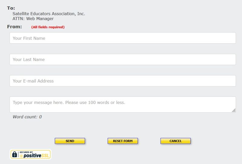
Click once the CONTACT US button on the SatEd.org home page. It will open a short, secure form for sending a comment or question about something in the SEA Newsletter, something on SatEd.org, or anything else related to the Satellite Educators Association, satellites, remote sensing, conferences, or... (Where does your curiosity and imagination take you?). The form is received by the SEA Web Manager and forwarded to an appropriate responder.
Click once on the SEA FORUM button on the SatEd.org home page. It will open the SEA Forum log-in page. Like CONTACT US, the SEA Forum can also be used to share brief comments or questions. Eventually, you may feel comfortable enough to become engaged with other forum members in a discussion (not in real time) about the topic of your comment or question. The forum offers a safe and secure environment for interaction with others of similar interest. You can respond to current open topics, start your own new topic, even send private email to other forum members.
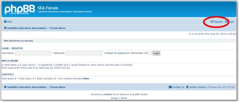
Use of the SEA Forum requires registration. That takes seconds to accomplish and opens the door for quick and easy interaction at your own pace and timing. The CONTACT US form is freely available without registration.
Here are the tools. What are you waiting for? Let's talk!
[ Back to Top ]
By SEA Newsletter Staff
March 1, 2026
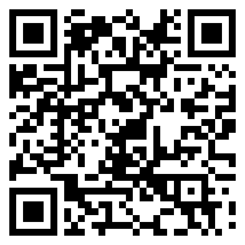
A new QR code now appears at the end of the SEA Newsletter. It opens the new SEA donation information page. SEA needs your help. The giving opportunities to support SEA have been expanded to include volunteer time.

The giving opportunities page reminds visitors that the Satellite Educators Association is a 501(c)(3) non-profit corporation -- all donations are tax-deductible. The page displays a list of some of the ways you could help SEA, a description of SEA's primary activities (what needs your support) and three ways to begin helping:
Do you like what you see in this newsletter or at SatEd.org? You can help make it available to more teachers and students with a contribution of your time, talent, or financial resources.
For most people, simply pointing your mobile phone camera at the QR code will open a link to SEA's donation information page at SatEd.org. If that doesn't work, simply point your browser to https://SatEd.org and click the red DONATE button.
Thank you for thinking of SEA.
[ Back to Top ]


By Simon Cracknell, President, Satellite Educators Association
In the classroom, teachers are always looking for tools to illustrate what we are teaching. Remote sensing via satellite technology makes this easier now than at any time in the past. In my classroom, the information they gather allows us, as well as scientists, governments, and environmental organisations to monitor change, predict risks, and take action to reduce environmental damage.
For the qualifications we teach in the United Kingdom (UK), for our equivalent of 10th and 12th grade, teachers are required to cover issues pertaining to the condition of the oceans, studying the sea surface temperature to discuss the increasing risk of tropical storms and the impact of increasing CO2 which can disrupt the ocean’s biological and physical pumps. Remote sensing provides data. Satellite Educators Association has shown us how to access data and the findings of scientists who study them. Below are some of the ways this is useful, through the lens of a secondary school teacher in the UK.
One of the most important uses of satellite technology is monitoring climate change. Satellites measure global surface temperatures, greenhouse gas concentrations, sea-level rise, and the extent of polar ice sheets. For example, satellites can detect changes in ice thickness in Antarctica and Greenland, which is a part of the exam specification we use. The linked issues, which we try to cover with our students, are best illustrated with a broad range of available data, presented using software I first became aware of during our M.Y. S.P.A.C.E. presentations. Without satellite data, it would be far more difficult to monitor the success of international agreements such as COP30 and onwards. This evidence-based monitoring helps governments design policies which our older students will spend time evaluating with a view on progress.
Satellites are also essential in reducing deforestation and habitat loss. High-resolution imagery allowed government led efforts to monitor illegal clearing of forested areas such as the Amazon in near real time. Illegal logging and land clearing can be detected quickly, enabling authorities to take enforcement action and see a marked improvement. Changing government priorities are also on the rise that will be helpful or harmful.
Environmental damage is often linked to natural hazards such as wildfires, floods, and volcanic eruptions. Satellite technology improves early warning systems and disaster response.
For example, satellites can detect heat signatures from wildfires and track their spread, helping emergency services respond more quickly. They also monitor rainfall, river levels, and storm development, improving flood forecasting. In volcanic regions, radar satellites can detect small ground movements that indicate rising magma, allowing authorities to issue evacuation warnings before eruptions occur.
With a wider range of tools in orbit, as well as the evolution from larger satellites to smaller designs that can be more easily taken in to orbit, countries can benefit, even if they are unable to launch these devices themselves. This makes the economic barrier to effective mitigation less of an issue than it has been in the past.
Air pollution is a major environmental and public health issue as well as an issue of a warming climate. Satellites measure concentrations of pollutants such as nitrogen dioxide and methane across the globe. This enables governments to identify pollution hotspots and evaluate the effectiveness of air quality policies.
For example, satellite data have shown reductions in pollution during periods of reduced industrial activity, providing insight into how human behaviour affects atmospheric conditions. In our classroom, we discuss how the redevelopment of brownfield sites in London and Manchester as well as other cities can potentially move in to new sectors of industry and see such improvements in air quality. Data from remote sensing can help us present changes over time.
A key advantage of satellites is their ability to provide global coverage and long-term data records. Environmental issues do not respect national borders, and satellites allow for consistent monitoring across countries and continents. This supports international cooperation and ensures that environmental protection efforts, as well our efforts to inform our students accurately, are based on reliable scientific evidence.
[ Back to Top ]


By John D. Moore, Executive Director, Institute for Earth Observations at Palmyra Cove, New Jersey
On the east coast, and specifically here in New Jersey, we have had two rather large and interesting snow events, with frigid temperatures. Blizzard conditions were posted from Washington, D.C. to Boston. Thanks to satellite imagery and Doppler radar, most were well prepared for the worst. However, this winter and early spring have represented an extraordinary convergence of classroom innovation, professional collaboration, and international momentum in Aerospace Science education. What continues to resonate most deeply is how student-driven work, originating in precollege classrooms, now intersects meaningfully with the broader aerospace community.
The year began at the AIAA SciTech Forum in Orlando, Florida, one of the premier gatherings of aerospace engineers, researchers, and educators worldwide. SciTech remains a powerful reminder that authentic aerospace education must mirror real-world engineering practice.
Across technical sessions and industry briefings, one theme was unmistakable, satellites are central to modern civilization. Whether supporting commercial enterprise, Earth observation, communications, navigation, scientific research, or national security missions, space-based systems underpin nearly every sector of daily life.
Yet despite their strategic importance, structured instruction in satellite systems remains rare in precollege education nationwide. At a time when Career Technical Education (CTE) and workplace readiness skills are receiving renewed national emphasis, this gap represents both a challenge and an opportunity. Satellite engineering integrates electronics, RF communications, coding, systems design, data analytics, documentation, and mission operations, precisely the competencies industry leaders identify as essential for the next-generation workforce.
I was asked to provide a "take-away" statement for my presentation, I happy to share:
The take-away from SciTech was clear. The aerospace workforce pipeline must begin earlier. Precollege education must evolve to reflect the realities of the space-enabled world.
On March 13th, in Washington, D.C., I will be honored to receive the Christa McAuliffe National Space Educator of the Year Award during a ceremony recognizing innovation and impact in space education at the National Space Club and Foundation at the Robert H. Goddard Memorial Dinner.
This recognition reflects far more than an individual achievement. It represents students building satellites, educators assembling antennas, colleagues advancing aerospace literacy, and a community committed to authentic learning experiences based on merit.
International collaboration continues to expand. Participation in the Alba Orbital PocketQube Conference in Glasgow highlights how rapidly the PocketQube form factor is transforming access to space.
Hosted by Alba Orbital, the conference convenes engineers, launch providers, educators, and satellite developers exploring affordable orbital deployment pathways. The 5cm PocketQube platform offers realistic, scalable access to flight.
For educators, this represents a genuine "Pathway to Space." The conversation is shifting from theoretical modeling to deployer standards, power budgets, vibration testing, and orbital licensing considerations. The infrastructure now exists for educational programs to transition from emulator platforms to flight-ready systems.
The message from Glasgow is powerful, access to space is broadening, and education must keep pace. I appreciate their professional collaboration.
The A3SatPQ initiative continues progressing from PocketQube-class emulator to a platform approaching flight readiness. Recent refinements underway include:
Students are no longer simply assembling hardware, they are engaging in documentation, verification planning, systems checks, and mission readiness analysis. These are authentic aerospace processes.
The developmental pathway remains intentional:
As satellites become increasingly central to commercial enterprise and national security infrastructure, there is an urgency to recognize and augment precollege educational endeavors that bring aerospace STEM (all four parts: science, mathematics, engineering, and technology) into sharp relief. While space systems dominate modern life, few structured satellite engineering experiences exist in precollege classrooms nationwide.
The enduring relevance of the Satellite Educators Association (SEA) can stand as a model for beginning to address that urgency. The SEA has long been ahead of the curve.
SEA's primary activities (historically and currently) provide assistance to educators and students in these areas:
Long before "Hands-on STEM" became policy language, SEA educators were building equipment, receiving live data, and integrating space into precollege classrooms, internationally. Today’s renewed emphasis on Career Technical Education (CTE) and workplace readiness only reinforces SEA's relevance. Satellite education naturally integrates:
These competencies align directly with modern CTE pathways and emerging aerospace workforce needs. SEA stands uniquely positioned not only as a professional association, but as a national catalyst, to expand structured satellite instruction into precollege education at scale. For more than three decades SEA has held conferences supporting collaborative work with business, government, and education. More recently, SEA is an active partner in the SmallSat Education Conferences.
This year I will be looking more closely into the applications of satellites, SmallSat or otherwise, that provide alternate trends in the applications of satellite imagery, data, and computer visualizations.
Current work at the Institute for Earth Observations includes presenting a paper at the IEEE Integrated STEM Education Conference (ISEC) held at Princeton University in March. Our paper is entitled, "A3SatPQ PocketQube Emulator: An Integrated Precollege STEM Aerospace Pathway." Building success with student co-authors gives them experiential learning opportunities in their future research studies.
Across Orlando, Washington, and Glasgow, one consistent truth has emerged:
The work ahead is not simply about building hardware, it is about building capacity. It is about equipping students with the skills, discipline, and systems necessary to contribute to a space-enabled world embracing Acquire-Analyze-Apply (A3).
It’s not too early to start thinking about the SmallSat Education Conference in Florida November 7-8, 2026, at the AMF Center for Space Education, NASA Kennedy Space Center - Visitor Center.
SEA’s legacy demonstrates that educators can lead this effort. The role of satellites has never been more important...neither has the role of satellite educators.
Remember -- you can teach anything with satellites.
Stay safe … stay well!
For now, I'm John...and this is my journey.
[ Back to Top ]


By Steve Mills, Retired Systems Engineering Scientist; owner and Chief Engineer of Polymath Geo
In my previous column I discussed space travel science fiction, and how it compares with science fact. I proposed that most space travel sci-fi invokes these three hypotheses:
I then examined in detail Hypothesis #1, known in the field of astrobiology (a.k.a. exobiology) as the Mediocre Earth Hypothesis, and compared it with the Rare Earth Hypothesis. These are competing, logical arguments in astrobiology and the "correctness" of either depends on as-yet-undiscovered evidence. In this column I’ll consider Hypotheses #2 and #3.
It is no exaggeration to say that the distances between stars are astronomical. To get some sense of the immensity of this, consider a thought experiment where the universe is downscaled to one ten billionth (1:10,000,000,000). In this model the Earth would be the size of a speck of sand 1.3 mm across. The moon would be a finer speck 3.8 cm away from the Earth, about two finger widths. This distance is the farthest any humans have ever traveled from Earth, during the Apollo Missions.
Now on this scale the sun would be the size of a cantaloup (14 cm) and would be 15 m from the Earth, about the length of a semi-trailer. And the Sun with all of its planets would fit easily into the Lower Manhattan neighborhood of New York City. Now how far away is Proxima Centauri, the nearest star outside our solar system? It is about 40 trillion kilometers or 4.2 light years away. On this scale it would be 4000 km away, about the distance from New York to Los Angeles California.1
This thought experiment is reminiscent of the Dr. Seuss children’s classic, Horton Hears a Who. In this story a civilization known as the Whos, live on a tiny planet the size of a dust speck, and only Horton, an elephant with giant ears, can hear them. So let us imagine that the Who-Planet is a speck on a flower in a pot in an apartment in our lower Manhattan neighborhood. The Whos are proud of their great technological accomplishment 50 years ago when they sent three Whonauts in a spaceship to visit another speck called Who-Moon, which is on another flower in that same pot. They plan a future mission to someday send Whonauts to Who-Mars, a speck on another flower in a window of the building across the street. However, Who-congress has never been able to appropriate enough funds for this very expensive mission. Who-congress has, however, funded many uncrewed research missions to Who-Mars and other distant specks in that Lower Manhattan neighborhood. So the Whos' space scientists know a lot about their neighborhood. These scientists know about Los Angeles, have calculated that to get there using their existing rocket technology would take almost a million years. Nevertheless, Who science fiction movies and novels regularly tell tales of this type of long journey taking just a few days.

Actually, it would be much easier for these Whos to travel from New York to L.A. than it would be for us to get from Earth to Proxima Centauri. The Whos have a huge advantage because there are many trillions of specks between the two cities, so they could travel from speck to speck, establishing a base on each one. Then their space travelers could refuel and resupply at each base. Then over many millennia they could expand their civilization, speck by speck, hopping from one to another until they span the entire North American continent. But unfortunately for us humans, there is almost nothing between our solar system and Proxima Centauri or any other star.
A light year is the distance light or radio waves travel in a year. Einstein's principle of Special Relativity states that nothing can travel faster than light, so no spacecraft, however fast, could ever take less than 4.2 years to get to the nearest star. And for a crewed mission, the spacecraft should not accelerate or decelerate much more than 1 G. Otherwise the crew would experience apparent gravity that would crush their bodies. This constraint would add at least another year to most trips. To travel to Proxima Centauri with this constraint would take at least 5.8 years, though the crew would experience time dilation and it would seem for them to take only 3.8 years. This would certainly be a problem for the Star Trek Starship Enterprise's "five year mission." So, consider again Hypothesis #2, "Travel between planets and star systems is quick, usually taking days, not years." To enjoy sci-fi, suspension of disbelief is often necessary, but in the case of Hypothesis #2 it is absolutely necessary. And that is even before we consider engineering challenges to achieving near-speed-of-light space travel. So next, let us examine Hypothesis #3.
As I have already explained, current rocket technology will never be sufficient to power spaceships between star systems. But there are proposed concepts that may make it possible at some time in the future. For us to consider what spacecraft technology might be possible in the distant future is somewhat like Neanderthal people considering what it would take to travel to the moon. Nevertheless, here is a list of some of these concepts:
Nuclear thermal rocket (NTR)—This uses a nuclear fission reactor to directly heat a liquid propellant, such as liquid hydrogen, to extreme temperatures, converting it into a high-pressure gas. This gas expands rapidly through a nozzle, creating thrust. This can in theory double the efficiency of a traditional chemical rocket. By itself this design is not powerful enough to ever propel humans to the stars, but it may someday make interplanetary travel faster and easier. It also might be useful for building other infrastructure for interstellar missions.
Nuclear pulse propulsion (NPP)—This generates thrust by detonating small nuclear charges (fission or fusion bombs) behind a shielded vehicle. Developed under DARPA's Project Orion in the 1950s-60s, it uses a large pusher plate with shock absorbers to convert blast energy into momentum, offering high thrust and efficient, fast interplanetary travel. It would not, however, be powerful enough for interstellar travel, but like NTR could be useful in building interstellar infrastructure. One obvious challenge of NPP is the danger of literally riding a thermonuclear explosion.
Fission fragment rocket (FFR)—This works by directly using the high-velocity, charged fission products (fragments) from nuclear fuel as propellant. It uses magnetic fields to guide these charged, radioactive fragments out of a low-density core, achieving extremely high thrust. One proposed design uses nanoparticles of fissionable fuel (or even fuel that will naturally radioactively decay) of less than 100 nm diameter. With exhaust velocities of 3% - 5% the speed of light and efficiencies up to 90%, the rocket would be able to achieve very high velocities near to what would be needed for interstellar travel. These systems are highly complex, so scaling them to be able to power large spacecraft will be difficult, and numerous technological challenges still remain.
Electric fusion rocket (EFR)—This design requires fusion power technology similar to what is under development at the International Thermonuclear Experimental Reactor (ITER). This earthbound reactor aims to harness nuclear fusion, the same process that fuels the Sun. The reactor combines deuterium, and tritium, two hydrogen isotopes, to create helium and a high energy neutron. If the ITER program is successful, it could eventually replace carbon-based fuel and solve the world’s problem of global warming/climate change. According to a 2025 National Geographic article, “The contraption fills a space equivalent of a 20-story building,” and is “likely the most complex machine humans have ever attempted to build.” While many highly respected scientists, including Stephen Hawking, have praised the program, some have declared it to be waste of resources, including the founding editor of the Journal of Fusion Energy, Lawrence Lidsky, who after a long career in the field declared fusion power a fantasy.2
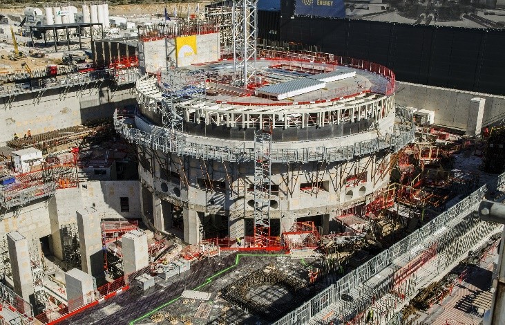
If, in fact, ITER is eventually successful in finding a way to produce almost infinite electric energy here on Earth, using nuclear fusion for space travel would still require reproducing ITER technology in space. Note the figure above, which shows the huge tokamak complex during construction in April 2018. Such thick concrete walls would not be appropriate for space travel. Even without the concrete, the tomack consists of large electromagnets made of copper and iron. This is why a disadvantage of the EFR concept is the large mass of the reactor.
The electrical energy produced by the fusion reactor would power ion thrusters. I described ion thrusters in one of my previous columns, and I said that they are not very powerful and are used almost exclusively for making small adjustments to the spacecraft trajectory, or to provide thrust for small interplanetary probes. Therefore, scaling this technology up to be propulsion on interstellar missions would be a huge challenge.
Other propulsion concepts—There are several other concepts for propelling spacecraft to velocities that would make interstellar travel possible. However, these are all so speculative that they are only worth a short mention.
This short review of interstellar space travel shows that if humanity ever is able to travel to the stars, it will be far in the future. It is altogether possible that the technical challenges I describe here are virtually insurmountable, and humans will never travel to the stars. In my previous column I described the Fermi Paradox that asks if intelligent life is so likely to arise in our universe, then why we have never met any of these other beings. One explanation is that interstellar travel is virtually impossible, and so these space aliens cannot travel to visit us, even if they wanted to.
In my next column I will review the long history of plans for crewed missions to Mars, and discuss the obstacles to such a mission. See you then!
References
[ Back to Top ]


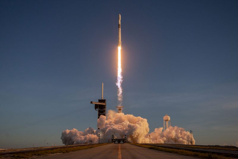
By Chris Burns, NASA;s Goddard Space Flight Center
at https://science.nasa.gov/missions/landsat/landsat-9-more-than-just-a-picture/
February 26, 2026
For over 50 years, the Landsat program has provided the longest continuous satellite record of Earth's land surface from space. Landsat 9, launched in 2021, is the latest mission in this remarkable legacy — building on decades of Earth observation with upgraded technology, including enhanced radiometric resolution, improved signal-to-noise performance, and polar night thermal imaging. Working in tandem with Landsat 8 to map the entire planet every eight days, Landsat 9's data is being fused with the European Space Agency's Sentinel-2 satellites to enable near-daily global observations, delivering sharper, more detailed observations that help scientists and communities monitor a changing planet.
[ Back to Top ]
From NOAA's National Environmental Satellite, Data, and Information Service
at https://www.nesdis.noaa.gov/news/noaas-next-jpss-weather-satellite-jpss-4-completes-solar-array-deployment-test
February 17, 2026
In an accordion-like motion, five solar panels successfully unfolded from the JPSS-4 satellite during its solar array deployment test, marking a major milestone for the next satellite launch in NOAA’s Joint Polar Satellite System (JPSS). As one of the major testing milestones for the weather satellite, the solar array deployment test verified that the satellite’s solar panels can deploy once launched into orbit, where they will provide the satellite with necessary solar energy for mission operations.
[ Back to Top ]
From NOAA's National Environmental Satellite, Data, and Information Service
at https://www.nesdis.noaa.gov/news/swfo-l1-renamed-solar-1-reaches-final-destination-one-million-miles-earth
January 27, 2026
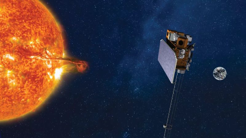
On January 23, 2026, NOAA’s Space Weather Follow On – Lagrange 1 (SWFO-L1) observatory executed its final engine burn, successfully entering its final orbital position at Lagrange point 1. Located roughly one million miles from Earth, this unique vantage point allows the satellite to continuously monitor the sun and space weather before it reaches our planet. The observatory has now been officially renamed to Space Weather Observations at L1 to Advance Readiness – 1 (SOLAR-1).
[ Back to Top ]
By Vanessa Thomas, NASA Explore
at https://science.nasa.gov/science-research/heliophysics/nasas-escapade-ready-to-study-space-weather-from-earth-to-mars/
February 26, 2026
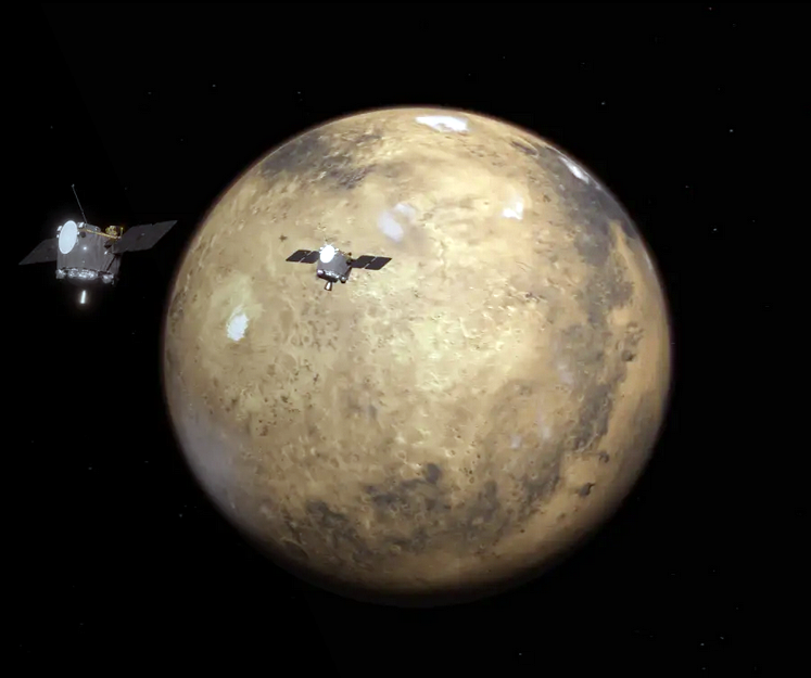
Mars is not what it used to be. Once warm, watery, and blanketed by a thick atmosphere, today the Red Planet is cold, dry, and draped by a thin atmospheric veil.
The main culprit is a relentless stream of particles from the Sun, known as the solar wind. Over billions of years, the solar wind has stripped away much of the Martian atmosphere, causing the planet to cool and its surface water to evaporate.
Now, NASA’s ESCAPADE (Escape and Plasma Acceleration and Dynamics Explorers) mission, which launched on Nov. 13, 2025, has turned on the science instruments that will investigate how this happened and how the Sun continues to influence the Red Planet. The science instruments, which are all operating as of Feb. 25, also will study space weather in new ways near Earth and on the way to Mars.
[ Back to Top ]


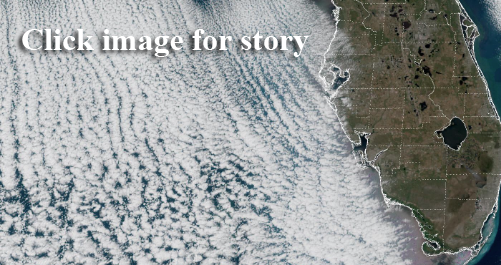
From NASA Earth Observatory Image of the Day
at https://science.nasa.gov/earth/earth-observatory/chesapeake-bay-locked-in-ice/
February 27, 2026
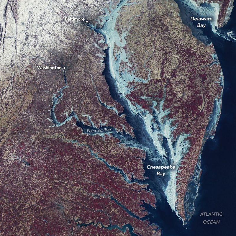
Residents of the U.S. Mid-Atlantic endured a formidable winter in 2025-2026, marked by several high-impact storms and prolonged stretches of cold temperatures that left parts of the Chesapeake Bay frozen over. Longtime residents may recall a winter nearly 50 years ago when the region saw even more widespread ice cover.
The MSS (Multispectral Scanner System) on Landsat 1 captured this image during the exceptionally cold winter of 1976-1977. The mosaic combines two Landsat scenes acquired on February 7 with a third captured on February 8. The landscape is shown in false color (MSS bands 6-5-4), in which ice appears in shades of blue, green, and white. On land, snow appears white, vegetation is red, and urban areas take on brown-gray tones.
Do It Yourself Hint...
Access this image yourself through GloVis, the USGS Global Visualization Viewer.
For help with GloVis and using Landsat datasets, see lesson plans GloVis and How Landsat Works in the SEA Lesson Plan Library.
[ Back to Top ]
From NOAA's National Environmental Satellite, Data, and Information Service
at https://www.nesdis.noaa.gov/news/noaa-launches-wildfire-data-portal-expanding-public-access-satellite-fire-information
January 26, 2026
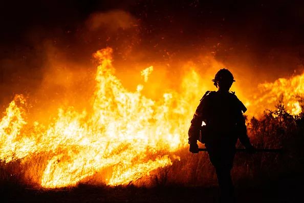
Wildfires burn millions of acres across the U.S. every year. According to the U.S. Department of the Interior Office of Policy Analysis, wildfires cost the U.S. approximately $424 billion annually, including firefighting resources, evacuations, health care costs, property damage, agricultural losses, and post-fire recovery. NOAA’s satellite observations play a vital role in wildfire response by enabling early fire detection and near-continuous monitoring. This data supports emergency response during active fire events, helps track smoke, air quality impacts, and particulate pollution, and informs long-term planning for land managers, policymakers, and communities.
Lead students into a wildfire case study using Wildfires From Space lesson plan in the SEA Lesson Plan Library.
[ Back to Top ]
SEA Newsletter Staff
March 2, 2026
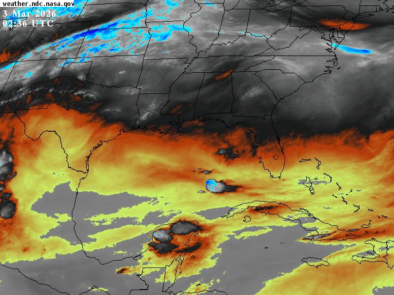
The Earth Science Branch of NASA's Marshall Space Flight Center (MSFC) in Huntsville, Alabama, offers access to most recent GOES imagery - most common views (CONUS and Full Disk) of the most common wavebands (Bands 2, 5, 7, 8, 13, and 14) from both GOES East and GOES West. Simply visit https://weather.ndc.nasa.gov/goes/ and click a selected thumbnail image. Then you can set controls to specify a single image or animation of 10-50 frames, output image size, quality, zoom factor - you can even set the color of the overlaid map of political boundaries (state or county level). Click the sample image to implement the controls you set. Right-click the image to download it or use it online - latitude and longitude of the cursor position are given as the cursor moves across the image. The image updates automatically as new imagery is available from the satellites.
Wait a minute! Aren't GOES images already available in near real-time from NOAA's GOES Image Viewer - both GOES East and GOES West, all wavebands, and all sector divisions? TRUE! So, what's the difference? While the GOES Image Viewer offers a greater range of products, MSFC offers the ability to further enhance the image and one more important difference: you can "build your own images." You can build the URL to access a near real-time image of the scene you selected in the set up controls. then simply click the URL to instantly download the current view of the scene you set up. That means you can easily accumulate multiple frames of the same scene over time for comparison.
Interesting tool -- give it a try at https://weather.ndc.nasa.gov/goes/.
[ Back to Top ]


From NOAA News & Features
at https://www.noaa.gov/news-release/noaa-deploys-new-generation-of-ai-driven-global-weather-models
December 17, 2025, updated February 17, 2026
NOAA has launched a groundbreaking new suite of operational, artificial intelligence (AI)-driven global weather prediction models, marking a significant advancement in forecast speed, efficiency, and accuracy. The models will provide forecasters with faster delivery of more accurate guidance, while using a fraction of computational resources.
"NOAA’s strategic application of AI is a significant leap forward in American weather model innovation," said Neil Jacobs, Ph.D., NOAA administrator. "These AI models reflect a new paradigm for NOAA in providing improved accuracy for large-scale weather and tropical tracks, and faster delivery of forecast products to meteorologists and the public at a lower cost through drastically reduced computational expenses."
[ Back to Top ]
From NOAA National Centers for Environmental Information
at https://www.ncei.noaa.gov/news/global-climate-202513
January 14, 2026

[ Back to Top ]


From NASA Jet Propulsion Laboratory
at https://www.jpl.nasa.gov/news/how-nasa-is-homing-in-from-space-on-ocean-debris/
January 26, 2026
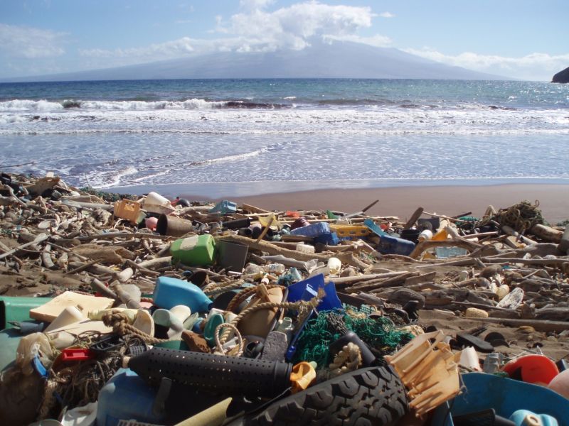
In late 2025, scientists reported that, for the first time, they were able to detect concentrations of plastic pollution on land using NASA’s Earth Surface Mineral Dust Source Investigation (EMIT) sensor aboard the International Space Station. The technology has inspired marine researchers to see whether it could also help track debris in our waters.
Before future generations of sensors like EMIT can be called upon to detect ocean litter, scientists need to know what to look for. Working with collaborators, NASA intern Ashley Ohall has built a newly published reference library containing nearly 25,000 molecular “fingerprints” from all manner of flotsam and jetsam, including rope, tires, metal, bubble wrap, buoys, and bottle caps. Given the overwhelming presence of plastic in marine debris, the library includes some 19 types of polymer.
[ Back to Top ]
From NOAA News & Features
at https://research.noaa.gov/five-ways-noaa-scientists-helped-improve-human-and-marine-life-in-2025/
February 25, 2026
NOAA led no shortage of scientific breakthroughs in 2025: from launching satellites containing new instruments to advance space weather observations, to deploying uncrewed systems for critical data that could improve hurricane forecasts.
Our 2025 NOAA Science Report focuses on advancements that contribute to NOAA’s robust research and development enterprise, help reduce the impacts of hazardous weather, and promote sustainable use and stewardship of ocean and coastal resources.
Here are five highlights from the 2025 NOAA Science Report.
[ Back to Top ]


From NOAA National Weather Service
at https://www.weather.gov/ilm/WinterStorm_Jan30toFeb1_2026
February 28, 2026
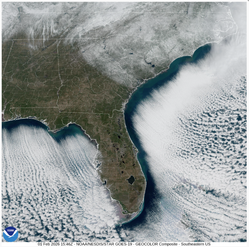
Record snowfall occurred across southeastern NC and northeastern SC from January 30 to February 1, 2026 as a potent winter storm impacted the region. Moisture moved northward from the Gulf of America ahead of an unusually deep and strong upper-level low pressure system and weak/broad surface low pressure across the Deep South on January 30 atop very shallow cold air across the Carolinas leading to a mixture of wintry precipitation during the evening and overnight. As the upper-level low to the west slowly shifted east on January 31, the aforementioned surface low pressure gave way to another developing low pressure system off the Carolina coast. Increasing lift from the upper low along with strong low-level frontogenesis led to an uptick in snow coverage and intensity across the area late on January 31 into the early morning hours of February 1 before the snow began to taper off from southwest to northeast around daybreak.
[ Back to Top ]
From NASA Jet Propulsion Laboratory
at https://www.jpl.nasa.gov/news/nasa-analysis-shows-la-nina-limited-sea-level-rise-in-2025/
January 29, 2026
The rise in the global mean sea level slowed in 2025 relative to the year before, an effect largely due to the La Niña conditions that persisted over most of the year. According to a NASA analysis, the average height of the ocean increased last year by 0.03 inches (0.08 centimeters), down from 0.23 inches (0.59 centimeters) in 2024.
The 2025 figure also fell below the long-term expected rate of 0.17 inches (0.44 centimeters) per year based on the rate of rise since the early 1990s. Though sea levels have increasingly trended upward in that period, years during which the rise in the average height was less usually have occurred during La Niñas — the part of the El Niño-Southern Oscillation cycle that cools the eastern Pacific Ocean, often leading to heavy rainfall over the equatorial portions of South America.
[ Back to Top ]


SEA Newsletter Staff
February 28, 2026
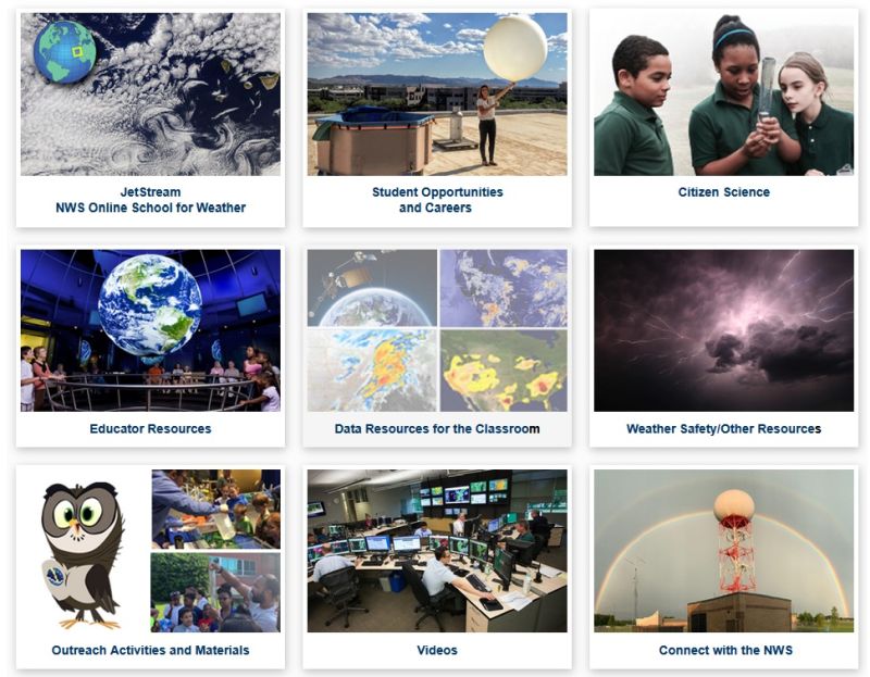
This issue of the SEA Newsletter spotlights the incredibly wide and diverse resource offerings for education from NOAA's National Weather Service. Accessed from the National Weather Service home page at https://www.weather.gov/, just click the EDUCATION link in the menu bar at the top of the page to access the buttons shown above.
Each of those buttons links to other pages with 124 more links to lessons, activities, infographics, videos, weather data, resources from other offices and agencies within the National Weather Service, resources from offices and agencies outside of but related to the National Weather Service, and so much more including access to JetStream, NOAA's online School for Weather. There is something here for every grade level from Kindergarten to university. There are reference materials, things for teachers, things for students - even things for career seekers.
This is a truly magnificent collection of links that must be explored to realize how many subject areas to which these materials can relate.
[ Back to Top ]


Suppose you are the captain of a commercial fishing boat harbored in Seattle, Washington, or Gloucester, Massachusetts, or Puerto Lopez, Ecuador, or Durban, South Africa, or any of a thousand other coastal cities that commercial fishing vessels call home port. Where will you go to fill your hold with fish for sale? Which fish will you catch? These questions have been answered over centuries of time by fishermen based on experience and reports of what others were catching at the moment and where. Today, modern fishermen use not only their knowledge of the seasons and fish behavior but also satellite-based remote sensing tools to predict the probable location of various fish types. Fish respond seasonally, even diurnally, to environmental changes such as water temperature, available food supply, and various types of currents. In this lesson, students will obtain and analyze satellite imagery of sea surface temperature to predict the probable location of schools of marketable fish species within reach of home port by commercial fishing boats.
| Grade Level: | 9-12 (Adaptable to other levels) |
| Time Requirement: | 2-3 class periods |
| Prerequisites: | Algebra |
| Relevant Disciplines: | Biology, Earth & Space Science, Geography |
[ Back to Top ]
Share your satellite-based lesson ideas with the teaching community.
Send us a complete lesson plan, or simply suggest a lesson idea. If you found the idea online, please share the source as well. The lesson can be about anything that helps connect learners with satellite-based technology - any grade level K-12 - any STEM subject area including geography.
Satellite-technology includes any part of the science, math, engineering, or technology of satellites, rockets, small-format satellites, and remote sensing instruments as well as the use of any environmental satellite data to explore questions related to aspects of global change and local impacts in the long term, short term, and catastrophic time frames. Of special interest are lessons providing opportunities for learners to inquire, experiment, and apply mathematics.
Perhaps you designed a lesson yourself - we will happily prepare it for future publication in More Lessons from the Sky and inclusion in the SEA's online Lesson Plan Library with full credit to the originating author(s). Perhaps you found a worthy lesson plan published elsewhere - we will do the research for possible inclusion in a lesson plan spotlight. In either case, you will receive full credit for developing and/or bringing the lesson to the attention of the teaching community. Don't forget to share your insights if you tried the lesson with students.
Please share your ideas at SEA.Librarian@SatEd.org.
[ Back to Top ]

![]()

This edition of the SEA Newsletter was produced in HTML5.
It is best viewed with most recent updates of Firefox, Edge, Chrome, Opera, or Safari.
©Satellite Educators Association, Inc. (SEA) https://SatEd.org SEA.Newsletter@SatEd.org
Satellite Educators Association, Inc. is a 501(c)(3) non-profit educational organization to which donations are tax deductible.
The SEA Newsletter is published quarterly in March, June, September, and December.
The SEA Newsletter is published on-line and available at no cost.
SEA terms, conditions, policies, and contact information are detailed HERE.
Unless otherwise listed, all photo and image credits are the authors of the articles.
Any opinons expressed in this Newsletter are those of the authors
and not necessarily those of the Satellite Educators Association, Inc.
or any of its officers, members, or representatives.
Many SEA Newsletter items contain third-party links to sites not governed by Satellite
Educators Association, Inc. The viewer is cautioned to be aware of the terms of use and
privacy policies for those third-party sites.
![]()
Like what you see?
SCAN or CLICK the QR Code
to help SEA carry on
with a donation of time, talent,
and/or financial support.
Thank you.