
OUR VISION
The world's finest educators supporting science, technology, engineering, and math (STEM) learning for pre-kindergarten to post-graduate students using real-world applications from satellites and satellite data.
OUR MISSION
To enhance the education environment to excite students about science, technology, engineering, and math through space-based technology -- satellites and satellite data.

Donald E. Westlake

Sharing the holiday with other people and feeling that you're giving of yourself, gets you past all the commercialism.
Caroline Kennedy

TABLE OF CONTENTS
Click a RED link to view article
ASSOCIATION NEWS
A LOOK BACK
PRESIDENT'S CORNER
STEVE'S SPACE
THE RAAB REPORT
SATELLITES
ANALYZE
APPLY
FOR TEACHERS
MORE LESSONS FROM THE SKY

December 1, 2025
In this issue, the top stories are What is SEA and Where Is It Going?; a wide array of For Teachers challenges, lesson ideas, and resources; and an expanded inclusion of small-format satellite issues.
The PRESIDENT'S CORNER looks at spaceflight risk versus regulation; JOHN'S JOURNEY briefly summarizes the SmallSat Education Conference; STEVE'S SPACE continues to illuminate space flight basics with a nod to science fiction and extraterrestrials. A new occasional columnist is welcomed in THE RAAB REPORT.
A LOOK BACK invites readers to compare today to the Satellites & Education Conference and major events of 5 years, 10 years, and 20 years ago.
SATELLITES describes the ocean applications of Sentinel-6B and the storm-studying mission of NASA's TROPICS.
ACCESS includes 10 memorable images from the GOES series satellites and a look at a red spider nebula.
ANALYZE tells of the shrinking Antarctic ozone "hole," the marked high-power of this year's Atlantic hurricane season, and a new look at a Martian mystery.
APPLY presents use of satellite data to warn of floods in Texas, a new flood mapping now covering 60% of U.S., and the trend toward Earth darkness.
IN THE NEWS reports the use of new mini ocean robots collecting hurricane data.
FOR TEACHERS brings an exciting variety of resources. From a crater detection contest to citizen scientist opportunities, from equipment sources and guidelines to engaging student activities, there is surely something here for everyone.
MORE LESSON FROM THE SKY highlights an updated version of Volcanic Ash Plumes from Space, a look at aerosols and atmospheric hazards from volcanic eruptions.
Enjoy!
--Editor

[ Back to Top ]

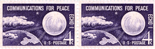
In 1960 postal officials used a satellite to help send a message. The experiment was named "speed mail" and utilized transmissions of messages by microwave that bounced off the Echo 1 satellite on November 9. The Echo satellite had been launched on August 12, 1960. It was essentially a large metalized balloon that would reflect microwave signals from Earth, allowing transmissions that bounced off the satellite from sender to receiver.
Postmaster General Arthur Summerfield was devoted to experimenting with new technologies for moving or processing mail whenever possible. The previous year he used a missile to deliver mail and was now ready to explore the possibilities of using space to speed mail delivery. He contacted the Natal Research Laboratory and NASA, which had worked to launch the Echo satellite. Both groups had completed successful communication tests and Summerfield asked that the Post Office Department be allowed to experiment with satellite-assisted mail.
The Echo I "Communications for Peace" stamp was issued on December 12, 1960 in Washington, D.C. The Bureau of Engraving and Printing produced 124,390,000 Echo I stamps.
Prior to the speed mail tests, the Department had experimented with earth-bound transmissions that would produce what would today be called a fax. Mail was transmitted by co-axial cables, microwave radio relay systems, and telephone wires between Washington, DC, Chicago, Illinois and Battle Creek, Michigan.¹ Among the items sent in the tests were letters, maps, blueprints, charts, and photographs. These successes led Summerfield to look to space as the next step in mail transmission.
In a press release, Summerfield called this next step "another major landmark in the development of our American Postal System." He laid out four basic steps for prospective senders to use in the new speed mail system:
Continue reading this fascinating story of speed mail from the Smithsonian National Postal Museum...
[ Back to Top ]
By SEA Newsletter Staff
December 1, 2025
Recently, an unasked question about SEA's focus came up. Should the Satellite Educators Association (SEA) be emphasizing "data analysis" or "engineering?" Data analysis is recognized as any part of accessing, visualizing, analyzing, interpreting, and applying satellite-based remote sensing data. Engineering, the E in STEM, involves (in this context) the design, construction, launch, and operation of small-format satellites such as CubeSats, ThinSats, and small-format satellite emulators. To better understand the question and how its answer will impact SEA's future, it may be helpful to review some of the past looking at the foundations of the SEA, what happened to the Satellites & Education Conference, how the SmallSat Education Conference is different yet the same, what SEA is doing now, and its prospects for the future.
The Satellite Educators Association was founded by Helen Martin and incorporated in 1989 following an overwhelmingly positive response to the first Satellites & Education Conference in 1988. The nonprofit Association (SEA) is a professional organization of educators and those who want to enhance the education environment to excite students about science, technology, engineering, and mathematics (STEM) through space-based technology. According to its By-Laws, the "Association is organized primarily for educational purposes utilizing satellite data and technology" and to produce an annual conference. Consider the acronym STEM. It starts with knowledge-acquiring science using the language of mathematics and followed by designing, manufacturing and operating new applications of those science-based facts (engineering), and the implementation of those designs to achieve practical goals (technology). SEA is about promoting a way of thinking among teachers and students through a lens of space-based activities.
For more than three decades, SEA has lived its definition by producing an annual Satellites & Education Conference bringing teachers together with representatives of government (including NOAA, NASA, USGS and more) and the aerospace industry in support of students. The Conference was held at West Chester University in Pennsylvania for fourteen years and moved to California State University, Los Angeles in 2002. The Conference continued on the West Coast until 2022. From 2002 to 2018, the Conference included the M.Y. S.P.A.C.E. Program (Multinational Youth Studying Practical Applications of Climatic Events), an international collaboration of students grades 7-12 engaged in self-selected research projects on the local impact of global environmental issues. The Association maintains a Web site offering how-to-do-it guidelines for accessing, analyzing, and applying satellite-based remote-sensing data as well as a full lesson plan library and quarterly online newsletter -- all at no cost to the user. Historically, SEA has emphasized reception of satellite signals and the processing of such data imagery whether from direct-readout or available archives online. Small-format satellites, and their availability to the educational community is a more recent development.

California State University, Los Angeles, was an important partner in hosting the Satellites & Education Conference. When the COVID-19 pandemic hit, the Satellites & Education Conference suffered lagging attendance and quality. Several years of online conferences were attempted using ZOOM, but the annual meeting of M.Y. S.P.A.C.E. school teams for collaboration was not possible. During and following the pandemic, university support for the Conference declined. The last Satellites & Education Conference in 2022 was the first face-to-face conference at Cal State LA after the pandemic. It was overly difficult to produce and attendance was much less than expected.
As the pandemic subsided, Kevin Simmons started the SmallSat Education Conference at the Kennedy Space Center in Florida. The focus of this conference was on student design, construction, and launch of small satellites such as CubeSats, ThinSats, and high-altitude balloon programs. A variety of small satellite emulators have also become available for testing designs and programming. The SmallSat Education Conference is growing in size and popularity since its inception in 2022. Beginning the following year, the Satellite Educators Association membership elected to annually support the SmallSat Education Conference financially in lieu of continuing to produce its own conference. Considering first-impressions only for the moment, the emphasis of the SmallSat Education Conference is engineering whereas that of the Satellites & Education Conference has been data analysis. A deeper look reveals attendees' thirst for both at both conferences.
The Satellite Educators Association currently offers these facilities on its Web site, SatEd.org:
These five sections of SatEd.org are the most active at this time. There is much more to explore at SatEd.org such as SEA's partnership with the ESIP, the Federation of Earth Science Information Partners. You are invited to visit SatEd.org any time to learn more.
Here are just a few of the most significant needs identified by the SEA membership and Executive Committee.
What can you do to help? SEA's most important asset is you. The future of SEA and its offerings is in your hands.
[ Back to Top ]
From the SEA Web Manager
A new online SEA Forum is available for all interested people to post questions and comments, the check in with colleagues and friends, to share information. This online bulletin board service is intended to enhance communications between SEA members and anyone else interested in topics related to SEA's Vision and Mission. The SEA Forum is open to students, educators both formal and informal, other professionals, hobbyists, and you.
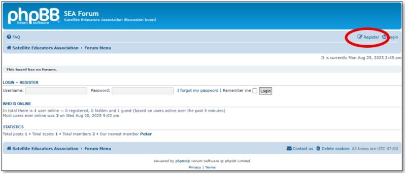
To get started in the SEA Forum, access SEA Forum from the SatEd.org home page and register as a new user. Once registered, simply log in with your registered username and password.
To register a username and password, simply click the SEA Forum button on the SEA home page or visit SEAForum.SatEd.org. Enter your own username and password and a valid email address. Registration is open both SEA members and non-members at no cost.
Registered users can start new topics, post questions, comments, answers. They can even communicate with each other via email.
Need help at any time? Just contact the SEA Forum Administrator at SEAForum@SatEd.org.
Of course, all SEA Forum users are expected to remain courteous and professional by adhering to the posted guidelines found on the Forum and HERE. Bulletin board posts will be monitored by a moderator. Inappropriate posts will be edited or deleted. Repeat offenders will be banned from the SEA Forum on a temporary or permanent basis.
You are invited to join the conversation today. Become a registered user on the SEA Forum. As a registered user, you can post or not -- that's up to you -- but you will always be up to date on what's happening.
[ Back to Top ]

From SEA archives
December 1, 2025
Remembering and learning from the past is foundational to effective future decision making. Here are just a few reminders of the recent past in SEA's drive toward today and tomorrow.
[ Back to Top ]


By Simon Cracknell, President, Satellite Educators Association
Over the past few years, commercial spaceflight activity in the U.S. has rapidly expanded. When there were fewer ‘players’ involved, it was simpler to manage the impacts that they may be having on our atmosphere, environment and even on people. Now more private companies are launching rockets, planning space-tourism flights, developing reusable vehicles, and seeking faster regulatory approval. It would be made easier by relaxing the regulation that are currently in place. The Outer Space Treaty of 1967 stipulates that nations are responsible and liable for all national space activities, but growth in this sector may be challenging the limits of this treaty.
The question appears to be asking if in trying to speed up innovation and reduce regulatory burden, are we undermining safety or environmental protections? Or are these changes both inevitable and necessary to maintain competition among those involved in space launches, commercially or otherwise?
There are significant reasons why we should be accepting a less regulated sector these days. The commercial space industry argues that slow or burdensome regulatory processes favour large incumbents so reducing competition. This may inhibit the growth of another country’s space industry as well as limiting new start ups, especially those with new ideas. Technology, often brought in by new companies, such as Space X is widely used now and is evolving rapidly. The sustainability we now see in the development of modern space flight means some of those regulations may not be appropriate any more. For example, one study argues the safety-framework for human spaceflight should be "adaptive and evolutionary." [Commercial Human Spaceflight Safety Regulatory Framework September 28, 2022]
Countries striving to enter or take a lead in enterprises such as space tourism, orbital launch services, or lunar missions will require some flexibility. Moreover, the traditional industry argues that overly heavy regulation may stifle domestic growth and shift business overseas. Both arguments tend to spark strong responses regarding safety, environmental impacts – these concerns have not gone away. Space launches and re-entries carry inherent risks: high speeds, large amounts of energy, massive vehicles, potential for failure, falling debris, and atmospheric re-entry hazards. One study says, "While spaceflight risks will never be completely extinguished...they should be mitigated and addressed proactively." [Commercial Human Spaceflight Safety Regulatory Framework September 28, 2022]
A discussion focus of an earlier President’s Corner was "space junk" and the simple premise that the more we send up, the more that can potentially come down. Some hardware items in seeming orbit do experience uncontrolled re-entry and thus pose a risk to people on the ground. Reductions in regulation may, in fact, increase risk to the general public.
Any high-profile accident may set the sector back if public trust is damaged. Such loss of trust could have a greater negative impact than slowing growth by regulation. People are also more aware of the impact of human actions on the environment, and some impacts of space flight are well known. Many launch sites are in or near ecologically sensitive areas like coastal zones and wildlife habitats. One news report raised alarm that a recent executive order might allow firms to circumvent environmental laws like the National Environmental Policy Act (NEPA) and the Endangered Species Act. [The Guardian-August 2025]
There is an understandable desire here to generate income from a growing sector. Many countries may seek to enter the "second space race" but may be less inclined to look after vulnerable environments or indeed safeguard people. Some may consider that this is unfair on those who are prepared to take precautions in order to safeguard those people at risk.
That said, the Outer Space Treaty was signed in 1967 and almost 60 years later, it does make sense that regulations and treaty expectations are fundamentally reviewed so that the spacefaring countries and others are given an opportunity to agree upon the appropriate checks and balances that should be in place. After all, the benefits of learning from our future interactions in space are better when shared with all countries and people. It is this educator’s hope that we can all strive to omit politics and mistrust for what is a monumental phase in the development of the human race.
[ Back to Top ]


By John D. Moore, Executive Director, Institute for Earth Observations at Palmyra Cove, New Jersey
The 2025 SmallSat Education Conference at NASA’s Kennedy Space Center was another inspiring gathering of educators, students, and satellite professionals, with nearly 700 attendees joining to share ideas, discoveries, and innovations. Once again, conference participants had the unique privilege of witnessing a live satellite launch, an experience that never fails to reinforce the excitement and relevance of aerospace education. Watching a payload lift off reminds all of us -- students, teachers, and mentors alike -- of the possibilities when curiosity, science, and engineering come together in the real world.
This year’s conference emphasized the ongoing challenge of integrating SmallSat Education into traditional classrooms, providing teachers with practical tools and strategies to bring authentic satellite experiences to their students. In these discussions, the focus was not only on broadening participation in aerospace science but also on helping students develop essential workplace skills, including coding, systems design, data analysis, and applied engineering Supporting the SmallSat Education Conference, the Satellite Educators Association provides a framework that ensures learners gain these capabilities in ways that are both meaningful and engaging, cultivating pathways toward careers in aerospace, geoscience, and technology - and has done so since 1988.
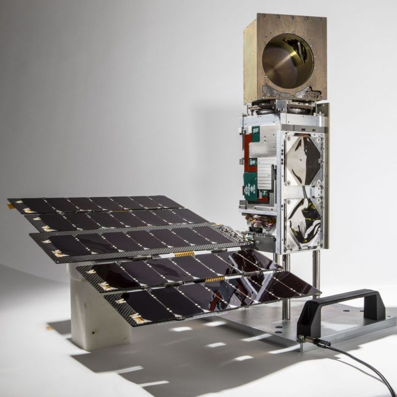
A highlight of the event was the presentation of the A3Sat PQ Emulator, which I delivered alongside my colleague Dr. Mike Jabot. The A3Sat PQ Emulator represents a significant step forward in precollege satellite education. Unlike simpler demonstration models, this PocketQube-class educational satellite emulator allows students to engage in a fully integrated simulation of satellite development and operations.
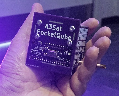
The A3SatPQ Emulator is designed to provide end-to-end mission experience. It includes a flight computer that can be programmed by students to execute specific tasks, a modular sensor bay that allows experimentation with payloads, and a data telemetry system enabling learners to receive, analyze, and apply real-time measurements. The emulator is structurally modeled after a 5cm PocketQube, giving students a hands-on understanding of how components must be designed, integrated, and balanced for actual spaceflight and develops Career and Technical Education (CTE) skills.
The system is also flexible and accessible, supporting testing on tethered high-altitude balloons, AEROKAT kite systems, and ground-based simulations. This allows teachers and students to run authentic mission simulations without requiring expensive launch contracts or specialized infrastructure. In essence, the A3SatPQ Emulator transforms classrooms, labs, and schoolyards into interactive aerospace laboratories, offering learners the chance to acquire, analyze, and apply the same skills used by professional engineers and satellite operators.
In our presentation, we also reflected on the legacy of my dear friend and colleague, Professor Hal Walker, whose support for SEA and advocacy for hands-on student experiences helped shape the early successes of programs like the A3Sat series. His contributions continue to inspire our work, and his memory was honored as part of this year’s conference presentation.
An exciting development for the A3SatPQ Emulator is the formalized collaboration with Dr. Jin S. Kang and the U.S. Naval Academy Small Satellite Laboratory. Starting in 2025, Midshipmen at United States Naval Academy (USNA) will be actively involved in the construction, validation, and testing of A3SatPQ Emulator units. This partnership serves multiple purposes: it provides precollege students with mentorship and exposure to university-level engineering practices while giving Midshipmen the opportunity to guide younger learners and refine system designs in a teaching context.
Midshipmen will work closely with precollege participants to assemble the emulator, integrate sensors, and program the flight computer for simulated missions. They will also evaluate system performance, ensuring the reliability of telemetry, power systems, and sensor payloads. Beyond construction, the collaboration is exploring future expansions of the A3SatPQ Emulator, including advanced imaging modules, enhanced telemetry capabilities, and deployable sensors. These enhancements will further bridge the gap between precollege education and authentic CubeSat and PocketQube engineering, creating a continuum of learning from schoolyard experiments to professional satellite operations.
This university–precollege partnership exemplifies the "Pathway to Space" philosophy, demonstrating that early, hands-on experiences with SmallSats can cultivate the skills, curiosity, and confidence students need to succeed in advanced STEM education and careers. Goal 1 is to make the A3SatPQ ready for space with modifications, and Goal 2, fly in space.
The conference also provided an opportunity to strengthen international collaborations, particularly with Alba Orbital, a leader in PocketQube development based in Scotland. Our discussions focused on how the A3SatPQ Emulator can serve as an entry point for precollege learners who may eventually participate in Alba Orbital-supported PocketQube missions. A live demonstration at their booth, showcasing the emulator’s capabilities and modular design, was recorded and will be shared on Alba’s YouTube channel.
I am excited to report plans to attend Alba Orbital’s annual conference in Glasgow in March 2026, where we will continue exploring ways to expand this collaboration, including joint educational initiatives and potential cross-continental student projects. By connecting students to global aerospace communities, we reinforce that learning, exploration, and innovation know no geographic boundaries.

Looking ahead, I will present the A3SatPQ Emulator at the AIAA SciTech Conference, whose primary objectives include fostering technical innovation, encouraging collaboration, and advancing STEM education across the aerospace community. My presentation will demonstrate how the A3SatPQ Emulator provides authentic, hands-on learning experiences for precollege students, bridging classroom instruction with real-world satellite design, assembly, and data analysis.
By showcasing how students can program the flight computer, integrate sensors, and analyze telemetry data, the session will directly support AIAA SciTech’s goal of demonstrating practical, innovative approaches to aerospace education. Attendees will see firsthand how precollege learners can gain workplace-ready skills while engaging with advanced technology in a structured, accessible, and collaborative environment. The presentation emphasizes not only technical competence but also problem-solving, teamwork, and project management, all essential skills for the next generation of aerospace professionals.
The 2025 SmallSat Education Conference reaffirmed the growing momentum behind hands-on aerospace science education. By integrating initiatives like the A3SatPQ Emulator with collaborative programs at USNA and international partners such as Alba Orbital, educators can provide students with authentic, meaningful pathways to explore satellite technology and develop skills critical for STEM careers. Once again, witnessing a live launch underscored the excitement and possibilities inherent in this field—reminding all participants why bringing satellites into classrooms and schoolyards remains a uniquely powerful teaching tool.
There is a "Pathway to Space," and it can begin here.
Remember -- you can teach anything with satellites.
Stay safe … stay well!
For now, I'm John...and this is my journey.
[ Back to Top ]


By Steve Mills, Retired Systems Engineering Scientist; owner and Chief Engineer of Polymath Geo
When I was growing up in the 1960’s, science fiction was my favorite book genre. I particularly enjoyed Ray Bradbury’s collection of short stories, The Martian Chronicles. But as an adult, after working in the space industry for several years, my feelings regarding science fiction began to turn into antipathy. The problem for me is that sci-fi creates such high expectations about what is possible with space travel that our current technology pales in comparison. A layperson might ask, "If NASA could put people on the Moon, is it that much harder to put people on Mars?" My answer would be, "Mars is over 100 times farther from Earth than the Moon, so, yes, it reasonably could cost 100 times more." And consider interstellar space travel, which is so common in sci-fi. The nearest star system, Alpha Centauri, is an astounding 105,000 times farther from the Earth than the Moon, and so a trip there with current technology would take many centuries.
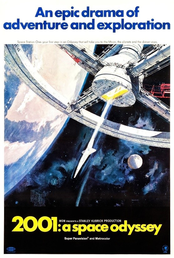
The broad genre of science fiction is often divided into two subgenres — hard science fiction and soft science fiction. Hard sci-fi puts emphasis on real science with credible speculation on future technological development. Soft sci-fi is much more speculative, sometimes violating well-known scientific principles. You would be correct if you guessed that I prefer hard sci-fi. Within soft-sci-fi there is a sub-subgenre called "space opera." Space opera has plots that often involve alien civilizations, space warfare and galactic empires. Star Wars and Star Trek franchises are the two most obvious examples of space opera. An example of hard sci-fi is Stanley Kubrick's 1968 movie 2001: A Space Odessey, which is based on several short stories by Arthur C. Clarke.
Whether hard or soft, most sci-fi that involve space travel invokes these three hypotheses:
The Star Trek original TV series is a good example of this. It is set in the mid-23rd century, and each week the Starship Enterprise visits another planet in some distant star system, where there is always another advanced civilization to engage with. Enterprise’s warp engines use advanced technology, matter-antimatter reactors, to propel it to faster than the speed of light. (Faster-than-light travel is impossible according to Einstein’s theory of special relativity, which is one reason Star Trek is considered soft sci-fi. The Star Wars universe uses a similar device called hyperspace.)
In this column I will focus on hypothesis #1 and will call it the "Mediocre Earth Hypothesis."
Some scholars consider A True Story, written in the second century AD by author Lucian of Samosata, to be the earliest known work of science fiction because it includes travel to outer space, alien lifeforms, and interplanetary warfare between the King of the Sun and the King of the Moon over the colonization of Venus. But the story contains no science to explain how the characters traveled and survived in space. So, it would more accurately be described as fantasy fiction or mythology.
A better candidate for the first science fiction story would be Johannes Kepler’s 1608 novel Somnium. Kepler, who discovered the laws of planetary motion, used his own knowledge of space science to write the book, and in it he describes a trip from Earth to the Moon. It accurately describes how the Earth would look from the Moon, and imagines plants, animals and intelligent beings living there.
Throughout most of history, people believed that supernatural beings lived in the heavens. Ancient creation stories describe how God or the gods created humans on Earth. So, authors such as Lucian of Samosata and Kepler simply assumed that the extraterrestrial beings in their stories were created by the same gods or God that created life on Earth. Therefore, no scientific explanation was considered necessary.
That all changed, however, when in 1858 both Charles Darwin and Alfred Russell Wallace published papers proposing natural selection as the driving force of biological evolution. After that time, science fiction writers began to imagine that if life could evolve naturally on Earth, then it could arise naturally anywhere in the universe. Also, based on Darwinian evolution, extraterrestrial life could evolve very differently than on Earth, so after that extraterrestrial beings in sci-fi were no longer modeled on humans. And by the mid-20th century Mediocre Earth Hypothesis was becoming a commonly held belief for both scientists and laypersons.
Scientists have debated whether there could be intelligent life on Mars since the late 19th century. Astronomers knew from blurry telescope images that, like the earth, Mars has polar ice caps, and they speculated that dark areas nearer to the equator were bodies of water. Astronomer Percival Lowell saw in these dark areas a network of canals that he speculated could have been built by an advanced civilization of Martians. In the popular imagination the belief in intelligent Martians originated in 1897 with British writer H. G. Wells' sci-fi story The War of the Worlds. Wells, who was heavily influenced by Lowell’s theory, described an invasion of Earth from an advanced civilization of Martians. His physical description of a Martian was as having an oversized brain and underdeveloped body that was more like an octopus than a human. The Martians were completely dependent on their high-tech machines to stay alive. This image was influenced heavily by Darwinism. A radio dramatization of The War of the Worlds in 1938, presented as mock news alerts, caused widespread panic when people believed these were real news reports.

By the early 20th century, however, some scientists began to doubt that intelligent life could exist on Mars. In 1909 better telescopic images of Mars proved that Lowell’s canals were an optical illusion and spectroscopic analysis of the Martian atmosphere showed no signs of water vapor or oxygen. Also, Martian ice caps were found to be frozen carbon dioxide (that is, dry ice), not water. In 1907, evolutionary biology’s cofounder, Alfred Russell Wallace, wrote a nonfiction book Is Mars Habitable? in which he concluded that Mars "is not only uninhabited by intelligent beings...but is absolutely uninhabitable."
Nevertheless, belief in intelligent Martians persisted until the 1960’s. When I was growing up in the early 1960’s I never heard the words "extra-terrestrial" or "space alien." Instead, we usually spoke of "space men" or "Martians," and the common assumption was that if intelligent beings were to visit Earth, they would be from Mars. I remember a popular sitcom, My Favorite Martian, when it first aired in 1963. It was more fantasy than sci-fi, but it did demonstrate how imbedded into the popular culture was the belief in intelligent Martians.
That changed dramatically in 1965 when the Mariner 4 mission performed the first successful flyby of Mars. It captured the first close-up images of the planet and showed that the Martian surface to be dry and barren, with craters similar to those on the Moon. It also revealed that Mar’s atmosphere was much thinner than expected, confirming Wallace’s belief that it was "absolutely uninhabitable," and this deflated hopes of finding intelligent life there. The Mariner 9 mission in 1971 was the first spacecraft to orbit Mars, and the early images showed the entire planet engulfed in a giant dust storm. When the dust finally settled in October 1971, images of the surface revealed dry riverbeds, and canyons that looked similar to those on Earth.
This suggested that in the distant past water may have once been plentiful on Mars, and it also raised hopes that life may have once been abundant there. Since then, exploration of Mars has focused mostly on discovering where there is water, and whether microbial life exists there now or has ever existed there. To date, there is no definitive evidence of Martian life, past or present. Later in this column I will discuss some ongoing research.
After the 1960’s there were almost no more sci-fi stories about Martians. Instead, the terms "space alien" or "extraterrestrial" became much more common in sci-fi than "Martian." The public perception changed so that aliens were simply from someplace "far, far away" as it says in the opening of the 1977 film Star Wars. And neither the sci-fi movie Alien in 1979, nor E.T. the Extra-Terrestrial in 1982 give any indication of where their title characters came from.
What then do we know about intelligent extraterrestrial life? Astrobiology (or exobiology) is the science that considers the possibility of life beyond Earth, but it has only recently become a serious academic field since the 1990’s. At that time it was a commonly held belief among both scientists and laypersons that Mediocre Earth Hypothesis was true. Here is the chain of reasoning that an astrobiologist might give to justify this hypothesis:
In 1950 at Los Alamos National Laboratory scientists were discussing these points when the Nobel Prize winning physicist, Enrico Fermi, asked why, if this were really true, then, are there no extraterrestrials that we can see? This question has become known as Fermi’s Paradox. In 1961 astrophysicist Frank Drake devised an equation from the bullet points above. At the time he proposed a project where radio telescopes could be used to search for signals from other civilizations in the galaxy. This effort would become known as the Search for Extra-Terrestrial Intelligence (SETI). Drake and later another famous astronomer, Carl Sagan, became primary advocates for this SETI effort. In 1980, Carl Sagan's Cosmos proposed a slightly modified version of Drake’s Equation, which I present here:
N = N* ⋅ fp ⋅ ne ⋅ fl ⋅ fi ⋅ fc ⋅ fL
where:
N = the number of civilizations in the Milky Way galaxy with which contact is possible.
N* = Number of stars in the Milky Way Galaxy.
fp = the fraction of those stars that have planets.
ne = the average number of planets that can potentially support life per star that has planets.
fl = the fraction of planets that could support life that actually develop life at some point.
fi = the fraction of planets with life that go on to develop intelligent life.
fc = the fraction of intelligent species that develop a technological civilization that releases detectable signs of their existence into space.
fL = fraction of a planetary lifetime graced by a technological civilization.
In this equation all of the terms that are expressed as "f" are fractions (or probabilities) and therefore must be less than or equal to 1.0. Critics point out that most of the terms in Drake’s Equation are unknown, and any estimates are based on pure conjecture. A few terms do have science-based estimates: N* ≈ 100–400 billion stars; fp ≈ 50% to 100%; and ne ≈ 0.2. Regarding ne, this is usually estimated by hypothesizing a "Goldilocks Zone," that is, an orbit far enough from the star that it is "not too hot, not too cold, but just right."
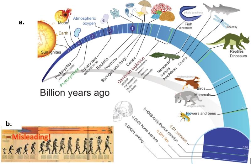
Now let us consider the two last terms in the equation, probability of intelligent life and the lifetime of advanced civilizations, fc and fL. A common misperception about evolution is that it is driven by a goal toward greater and greater complexity, and that humans, with our high intelligence, are therefore at the apex of this process. This belief is called orthogenesis, but it is not consistent with modern evolutionary thought. The only goal in evolution is survival, not complexity. In the contest of "survival of the fittest," we humans want to believe that with our cognitive abilities, we are the fittest of the fit. Charts such as those in the two graphics above reinforce this anthropogenic bias. These charts show modern humans as the final link in the chain of life, but evolution is not a chain — it is a tree with millions of branches — and humans are just one branch on that tree. So, if not humans, then which species is the "fittest of the fit?" By sheer number of organisms, it is probably the marine bacterium, Pelagibacter ubique, with a population estimated to be around 300,000,000,000,000,000,000,000 (or 3×10^27, or 300 septillion). Pelagibacter ubique is not only one of the oldest species on earth, it is also one of the simplest. But pitting humans against bacteria is not a fair comparison. Darwinian natural selection is often summarized as "survival of the fittest," but a better phrase would be "survival of the fittest within a niche." Bacteria and humans simply do not occupy the same niche, so this comparison is irrelevant. Understanding "niche" is essential to understanding evolution, but it is a complex concept beyond what I can explain here, so I encourage readers to do their own further study.

About ten thousand years ago there were only about one million humans on the entire Earth, that is about the population of Jacksonville, Florida, a moderately sized US city. The human population of Earth is now about 8 billion, that is eight thousand times more people. Was this eight-thousand-fold increase because humans evolved to become smarter or stronger, and therefore more fit to survive? No, anthropologists have determined that humans 10,000 years ago had about the same intelligence and the same physical strength as they do today. Rather, what has changed is that humans discovered agriculture, they realized that they could plant crops rather than gather them and could domesticate animals rather than hunt for them. Essentially, humans discovered that they could manipulate their niche in the world and could expand it. This change 10,000 years ago is called the Neolithic Revolution. As human cultures began to transition from hunting and gathering to agriculture and settlement, population increased and large cities arose with monarchs and laws. This was the start of what we call civilization, where thousands of people could work together toward a common goal. Those goals could be to develop commerce, to build huge monuments to their kings or gods, or to conquer and control neighboring civilizations. With civilization came the development of mathematics, writing and many new technologies, eventually including space technology.
We should not think that civilized societies are somehow superior to hunter-gatherer societies. Civilized people may call hunter-gathers disparaging terms such as "barbarians," "savages," or "primitives," but civilizations have probably caused more war, genocide, ecological havoc, and human misery throughout history than "primitive" peoples ever could have. Nevertheless, when considering the topic of this article, extraterrestrial intelligence, we must think about advanced technological civilizations, since hunter-gather societies could not have developed space travel.
Carl Sagan's explanation for Fermi’s Paradox is that we cannot know the lifetime of our own civilization. He believed that it may be very short relative to the lifetime of a planet if maybe civilizations tend to destroy themselves quickly through nuclear warfare or environmental catastrophe. This eventually spurred him to become an advocate for nuclear disarmament and the environment.
If the Mediocre Earth Hypothesis is true, then N is very large. Scientists such as Drake and Sagan argued that Earth is a typical rocky planet in a typical planetary system, located in a non-exceptional region of an average galaxy.1 They assumed that most of the fractions in Drake’s Equation are large (that is, not rare) even without solid evidence either way. They based their assumptions on the Mediocrity Principle, which can be stated as "anything seemingly unique to us is actually one out of many and is probably average."2
Another proposed resolution of Fermi’s Paradox is that there are indeed many advanced civilizations out there, but they are actively hiding from us. The reasons proposed are that maybe they want to observe Earth like a zoological preserve (the "Zoo Hypothesis")3 or that they fear being attacked by us because of our violent nature (the "Dark Forest Hypothesis")4. These hypotheses are the basis of many sci-fi stories, for example, The Day the Earth Stood Still, Close Encounters of the Third Kind, The X-Files, and Men in Black. But such a hypothesis becomes scientifically problematic. How can scientists observe beings that are actively hiding? It is like trying to prove or disprove the existence of leprechauns.
After 75 years Fermi’s Paradox has still not been resolved, so another idea is gaining traction. In 2000, Peter Ward, a paleontologist, and Donald E. Brownlee, an astrobiologist, published the book, Rare Earth: Why Complex Life Is Uncommon in the Universe. The Rare Earth Hypothesis argues that for Earth the Mediocrity Principle does not apply because it has implicit Survivorship Bias. Instead of the Mediocrity Principle, the Anthropic Principle is invoked. It says that we, as living, conscious observers, must necessarily find ourselves in a place suitable for intelligent life, or else we wouldn't be here to observe those conditions. Having already won the "evolutionary lottery," we needn’t be surprised to find ourselves as winners. But this tells us nothing about how many other winners there are, or what the odds are in this lottery.5 So while the Anthropic Principle does not prove that Earth is special or rare, it does allow for that as a possibility and it also means that we do not have to assume a mediocre Earth.
Here are some of the reasons Ward and Brownlee give for why conditions for intelligent life are rare in the universe:
Ward and Brownlee coined the term "Rare Earth Hypothesis," but they were not the first to suggest the idea. George Gaylord Simpson (1902- 1984), considered by many as the most influential paleontologist of the 20th Century, argued that evolution is dominated by chance, and that human-like intelligence is so complex that it is extremely unlikely, even on Earth. He called the field of astrobiology a "science without a subject."6 Cosmologists John D. Barrow and Frank J. Tipler in their book, The Anthropic Cosmological Principle, defend the hypothesis that humans are likely to be the only intelligent life in our galaxy,7 and science writer and futurist Marshall T. Savage wrote, "The extraterrestrials aren't here.8 They've never been here. They're never coming here." Evolutionary biologist and bestselling author, Richard Dawkins, has opined that life is probably very rare throughout the universe.9
There are many well respected scientists on both sides of the debate between the Mediocre Earth Hypothesis and the Rare Earth Hypothesis. So which theory is correct? That is actually a trick question, because these are hypotheses, not theories. A theory needs solid evidence based on some reliable data. Neither of these hypotheses have enough empirical evidence to raise them to the level of theory. So far there is only one planet that we know of that has life, our own Earth. So, what ongoing research is there that may one day change one of these hypotheses into a theory? Here is a review.
An exoplanet is a planet outside of our own Solar System, and the first confirmed detection was in 1992. Since then, there have been about 6,000 confirmed exoplanets detected, with 1,000 systems having more than one planet. What has changed since 1992 is that several satellite systems with a mission specifically dedicated to exoplanet research. Most notably, NASA's Kepler and TESS missions have discovered about two thirds of these exoplanets. These space telescopes are designed specifically to discover exoplanets, and once the discoveries are made, more powerful ground and space telescopes such as the JWST are used to study the planetary systems in more detail. This includes in some cases spectroscopic analysis of exoplanetary atmospheres for biosignatures and biomarkers, but to date no evidence of life has been found.
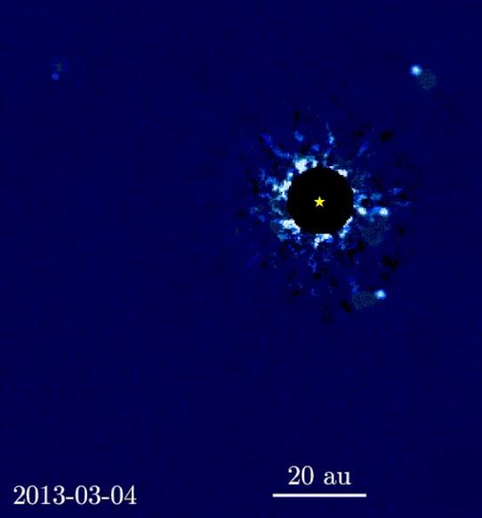
There are only a few exoplanets that actually have been imaged directly. The problem is that the star is so much brighter (usually billions of times brighter) than the planet, so it is almost completely lost in the glare from the star. To minimize this problem, an occulting mask is inserted inside the telescope to block most of the light from the star. This is not a simple task, and extreme accuracy in the design is necessary. Figure shows one successful image of a system with four exoplanets.
The vast majority of exoplanets have been discovered using the transit method, which is used by the Kepler and TESS missions. The intensity of the star is carefully measured over time, and if a sudden drop is detected, this indicates that an exoplanet is passing in front of the star. By measuring the change in intensity and the time between these eclipse events, scientists can determine the planet’s approximate size and the period of its orbit around the star. The problem with this method is that the chances are very low for a planet’s orbital plane to be so perfectly aligned with the Earth that this occurs. Also, this alignment is much more likely for exoplanets orbiting very close to their star, but we are more interested in Earth-like planets that are within the habitable zone, and detecting these using the transit method is very much less common. Also, very large exoplanets similar to Jupiter are much easier to detect using this method (or any other method). So, if our goal is to discover exoplanets similar to Earth we are at a disadvantage.
There are around 90-100 confirmed exoplanets that are about Earth-sized and within the habitable zone of their parent star. Taking all this into account it is estimated that about 1 in 5 Sun-like stars have an "Earth-sized" planet in the habitable zone.10 This means that there are about 11 billion Earth-like planets within our Milky Way galaxy. This, then, is one mark for the Mediocre Earth Hypothesis and one against the Rare Earth Hypothesis.
Abiogenesis is the process whereby life arises from non-living matter. In Drake’s Equation, the term fl is the fraction of planets that could support life do at some point. This could be restated as the probability of abiogenesis occurring. Unlike evolutionary biology, which is today very well understood, abiogenesis remains one of the great unsolved problems of science. What we can say is that it happened once and only once on Earth at least 3.8 billion years ago.11 Some genetic research had indicated that the Last Common Ancestor (LUCA) of all living things was about 4.2 billion years ago.12 Abiogenesis is that process that led to LUCA.
The following graphic shows the hypothetical stages of abiogenesis. The first question to answer is what was the environment on the young earth about 4 billion years ago? Even this question does not have a complete answer. There is evidence that Earth may have been a predominantly oceans between 4.4 and 4.3 billion years ago, though it is debated about whether there was any exposed land.13
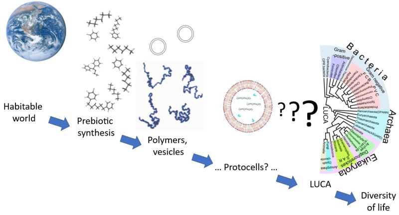
Several environmental settings have been proposed for the origin of life. They reflect different theories on prebiotic compound availability (mostly organic compounds), and on which natural energy source would drive the process. Here is a list of the most studied theories: deep sea hydrothermal vents; hot springs; warm lakes; tidal pools; cold melting ice; and inside the Earth’s crust. None of these have been ruled out, and there is no real consensus among researchers about which is the most likely.15
Regarding the origin of complex organic polymers (RNA and DNA), the most popular is the RNA World Hypothesis. This is the theory that self-replicating RNA molecules proliferated before the evolution of DNA and proteins. The next hypothetical step in Figure 6 is the evolution of protocells, that is, how did cell walls evolve? The Lipid World Theory postulates that the first self-replicating object was lipid-like, and these developed into protocells.16 There is a chicken-and-egg problem here because in all living cells DNA provides the instructions for how a cell creates its own cell walls by coding for the specific proteins needed to build them. There is no theory yet to build a bridge between the chemistry of RNA, DNA and lipid-based protocells.
NASA and ESA both fund research into abiogenesis because understanding how life began on Earth tells us something about how life may have originated elsewhere. Currently there is no consensus regarding many of the basic outlines of abiogenesis. The lack of consensus regarding abiogenesis is one mark for the Rare Earth Hypothesis and a mark against the Mediocre Earth Hypothesis.
As I mentioned above, early exploration of Mars proved that it was a desolate planet with no evidence of life. However, there is evidence that there is some frozen water on the surface and probably much more underground. There is also evidence there was in the distant past vast quantities of water there.
There are now two working rovers on the surface, NASA’s Curiosity and Perseverance. There are also seven working orbiters studying the planet, four by NASA, two by ESA, one by United Arab Emirates and one by China. One goal of most of these missions has been to determine if there is now or has ever been life on Mars. Currently, the surface of Mars has strong ionizing radiation that would kill all microbial life on the surface, and the soil would be toxic to living organisms. Therefore, the consensus is that if any life exists or ever existed there, evidence might be found in the subsurface.
In June 2018, NASA detected seasonal variation of methane levels in the Martian atmosphere. There was some speculation that could be caused by methane-producing and methane-consuming microorganisms. But methane is a simple hydrocarbon that can be produced from other nonbiological processes, so this is not considered as evidence of life.
In September 2025, NASA researchers found a rock from the Perseverance rover had a "potential biosignature." It showed features consistent with possible ancient microbial activity similar to what has been seen in microbial fossils on Earth. Currently, this is considered a potential biosignature. This sample, called the Cheyava Falls rock, along with other rock, atmosphere and soil samples are being collected and stored in tubes by Perseverance rover, with plans to return them to Earth on a later NASA-ESA mission called Mars Sample Return (MSR). When these samples are returned to Earth, they will be analyzed by scientist, just as the Moon samples from the Apollo Mission were. Only then will we know if Cheyava Falls rock is really a Martian fossil.
However, in 2023 NASA put the MSR program on pause. The $11 billion cost was considered unfeasible. So, for now, the Cheyava Falls rock waits for us. If MSR does succeed in eventually bringing it to Earth, and if it were actually shown to be conclusive evidence of ancient life from Mars, it would be among the greatest scientific discoveries of the century. But I wonder if the public would recognize the significance of such a discovery. After all, sci-fi has so much raised our expectations regarding extraterrestrial life, would people get excited about extraterrestrial microbes?
In my next column I’ll consider Hypotheses #2 and #3, that is, what kinds of spacecraft would be needed to make travel between planets and star systems as quick and easy as it is in sci-fi.
References
[ Back to Top ]


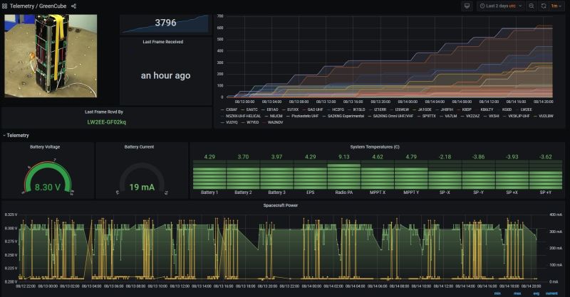
By Fredric Raab, College of the Desert, California
SEA welcomes Fredric Raab to the cadre of contributors to the SEA Newsletter. Fredric Raab is an Adjunct Professor at College of the Desert in Palm Desert, California. As a licensed amateur radio operator with a special interest in satellites, Raab is a member of AMSAT, the non-profit Radio Amateur Satellite Corporation. He presented "Bridging Orbit and Classroom" at the 43rd annual AMSAT Space Symposium and Annual General Meeting at Phoenix, Arizona in October 2025.
This paper addresses the challenge of interpreting satellite telemetry data and relating it to real-world satellite behavior. It introduces a powerful synergy between SatNOGS, a global open-source network offering free access to over 12 million satellite data downloads, and the CubeSatSim (CSS), AMSAT's low-cost satellite simulator.
SatNOGS enables students to "adopt" on-orbit CubeSats, providing the experience of being a satellite operator by scheduling downlinks and monitoring dashboards. To overcome the difficulty in interpreting this real-world telemetry, the CubeSatSim offers a hands-on, controlled environment. Students manipulate the CubeSatSim to directly understand how sensor data reflects solar panel performance, orientation, spin rates, and radio communications. This practical experience enhances their ability to interpret SatNOGS dashboards, demystifying the conversion of "waterfall signals into bits" and "bits into data". Together, SatNOGS and CubeSatSim provide both real-world data and practical understanding of telemetry data.
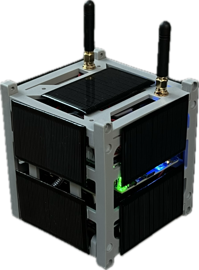
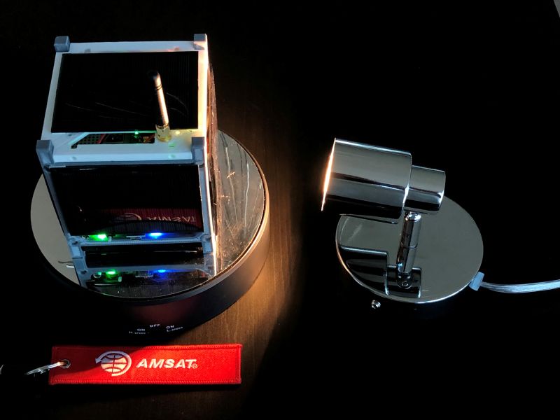
Every year, dozens of educational institutions place CubeSats into orbit. Many more institutions and students aspire to join their ranks but cannot due to costs and limited launch availability. However, these students can gain the knowledge and experience of building and operating a CubeSat by assembling AMSAT’s CubeSat Simulator and by “adopting” an existing on-orbit CubeSat on SatNOGS.
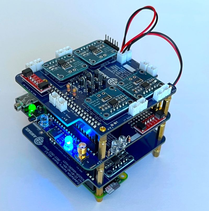
AMSAT's CubeSat Simulator (CSS) is an inexpensive, fully functional CubeSat, but is not space-worthy. It contains most of the components of a 1U CubeSat: frame with solar panels on each side, rechargeable batteries, power monitoring, flight computer, UHF/VHF radio board, camera, payload computer, inertial measurement unit (IMU) and environmental sensors. It is available as a no-solder kit that can be assembled by students in less than a day.
The CSS transmits operational telemetry data typically sent by all CubeSats: power output (voltage and current) of each solar panel, battery power, IMU data, sensor data, general health of each subsystem. This data is received using an inexpensive Software Defined Radio (SDR) dongle connected to a Raspberry Pi or a Windows system. The raw data is interpreted in real time and displayed by an AMSAT developed program: FoxTelem.
AMSAT has developed a series of hands-on educational activities for the CSS and FoxTelem to teach students how to read telemetry data and relate it to satellite performance.
SatNOGS is a global network of open-source ground stations operated by educational institutions, hobbyists and space enthusiasts. These stations receive data from orbiting educational satellites and upload the data to an open access database that as of September 2025 contained more than 12 million observations from 2300+ satellites. This data is available to anyone via the SatNOGS website. In addition to raw and decoded data, dashboards have been developed for some satellites to provide visual access to operational data.
Much of the operational data contained within SatNOGS is the same as reported by the CSS. And SatNOGS dashboards are similar in function to FoxTelem graphs.
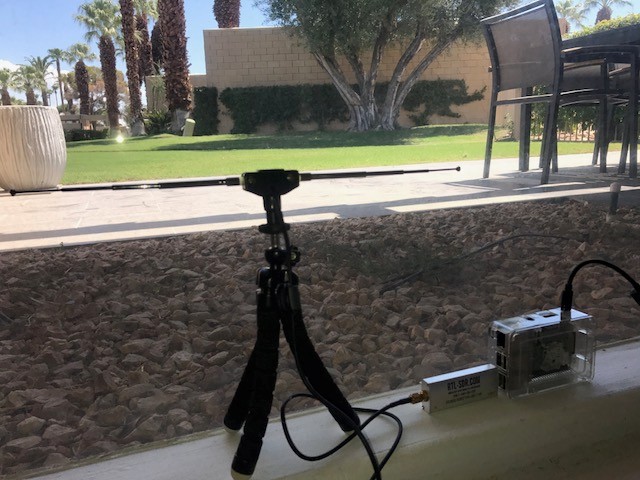
A minimal SatNOGS ground station, consisting of a Raspberry Pi, SDR dongle and dipole antenna, can be built for less than $150US. Software and detailed instructions are available on the wiki found on the SatNOGS website.
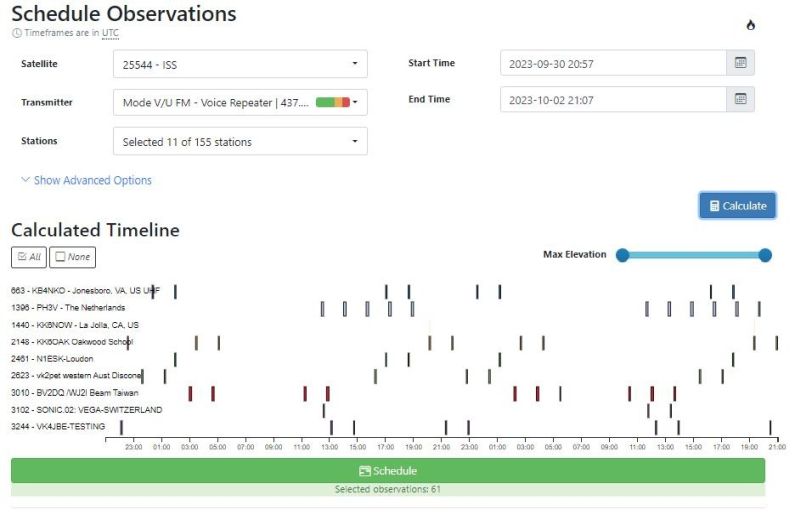
Ideally the antenna is outdoors and elevated, but as this station shows, a functional station can be indoors as long as it has a clear view of some portion of the sky. Once the station is on-line and registered, students can schedule observations (downloads) on multiple SatNOGS stations around the globe.
By selecting a dozen geographically spaced stations, they can establish their own global virtual down-link network.
Once a CubeSat is on-orbit, its operators need to continuously monitor its health and collect scientific data. By "adopting" an existing, on-orbit CubeSat, students have the experience of being a satellite operator without the expense and risk of launching their own CubeSat. Using published information, students learn about their "adopted" CubeSat, its mission and orbital path, communications protocols used and data returned, etc. By using SatNOGS to schedule data downlinks across their "virtual network" and monitoring the CubeSat’s dashboard over a 1 to 4 week period, students learn about the CubeSat's communications, operations and performance. As well as experiencing some of the activities of a satellite operator.
One challenge from viewing SatNOGS telemetry is relating it to the satellite’s orientation and behavior in space. It’s a dynamic environment of constantly changing data. It may be difficult to interpret data abnormalities.
The CSS provides a controlled, hands-on environment to collect data from a CubeSat. The CSS can be held stationary for an extended period of time allowing students to note readings from the solar panels and IMU. Then it can be rotated 90 degrees showing students how the readings change with position and orientation. After repeating this exercise with multiple positions on each of the three axes, students can construct a mental image of how telemetry data relates to satellite orientation.
Students can take the CSS in hand and simulate a tumbling CubeSat. Placing the CSS on a rotating turntable in front of a bright light source (or better in outside sunlight), students can use FoxTelem to plot how the solar panels output change with each rotation. And by slowly moving a cardboard panel between the CSS and light source, students can simulate the CSS entering and leaving eclipse.
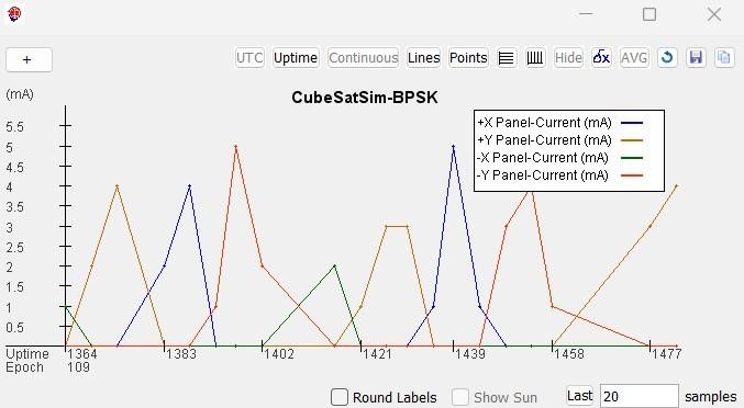
The CSS software also has a simulated telemetry mode in which the CSS transmits nominal data along with data indicative of a failed component. Students are challenged to determine the cause of the failure.
The knowledge gained from these CSS activities enable students to better understand the telemetry from their "adopted" satellite.
Where does one start? While this can be done as an individual exercise, it’s better (and less work) as a group exercise, either as a classroom or space club activity.
First explore the SatNOGS.org website. Then assemble a minimal ground station and start scheduling observations on your station. Once your station is on-line, look at the SatNOGS network map and schedule simultaneous observations over several other stations, some nearby and some far away.
Assemble students into teams of 3 to 5. Each team picks a satellite for adoption. Ideal adoptees have a dashboard, are currently active and successfully received by numerous stations, have more than 6 months of on-orbit data available, and documentation is readily available via the owner’s website.
Each team learns as much as they can about their satellite. They schedule downlinks across their global virtual network, monitor received data and compare date to historical data over a 2 to 4 week period. At the end, they present their research and findings to the group.
For real excitement, students can adopt a satellite before launch. SatNOGS often publishes information on their forum about ride-share missions pre-launch. Students can often watch SpaceX ride-share deployments in real-time on YouTube or X. CubeSats typically start transmitting soon after deployment. Dozens of SatNOGS station owners may compete for bragging rights to be the first to receive the signal. It can be a fun and involving exercise for students, but frustrating. Expect many observations with no signals.
This combined approach offers the hands-on experience of building and understanding a CubeSat (via CubeSatSim) and access to real telemetry with the experience of being a satellite operator (via SatNOGS), all without launch risks. This powerful framework fosters deep engagement with space science and engineering.
For more information, visit SatNOGS.org, CubeSatSim.org, or Amsat.org.
[ Back to Top ]


From NOAA National Environmental Satellite, Data, and Information Service
at https://www.nesdis.noaa.gov/news/sentinel-6b-launch-contributing-key-noaa-ocean-applications
November 17, 2025
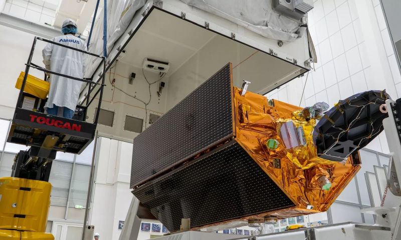
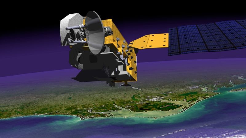
The Sentinel-6B (S-6B) satellite was launched on November 16, 2025, at Vandenberg Space Force Base in California. It is the second satellite of the Sentinel-6 series of spacecraft. This series is part of an international partnership with NOAA, European Organisation for the Exploitation of Meteorological Satellites (EUMETSAT), NASA, and the European Space Agency (ESA), with support from the French space agency, Centre National d'Études Spatiales (CNES). The first satellite of the mission was Sentinel-6 Michael Freilich (S-6 MF), also known as Sentinel 6-A (S-6A), which was launched in November 2020.
The S-6B instruments, such as the radar altimeter, will collect observations of oceanography data by bouncing signals off the ocean surface to make fundamental and precise measurements of sea level, wave heights and marine winds. These include measurements of ocean topography (sea surface height), atmospheric water vapor, and global navigation satellite systems (GNSS), which will collect more detailed information about atmospheric temperature and water vapor.
[ Back to Top ]
By Kate D. Ramsayer, NASA Small Satellite Missions
at https://www.nasa.gov/blogs/smallsatellites/2025/11/25/nasas-tropics-completes-storm-studying-mission/
November 25, 2025
A NASA mission that studied the interior of hurricanes collected its final data on Nov. 12, as the last two CubeSats in its fleet were powered down prior to re-entering Earth’s atmosphere.
The TROPICS (Time-Resolved Observations of Precipitation structure and storm Intensity with a Constellation of Smallsats) mission originally consisted of four identical, milk carton-sized satellites that launched in May 2023. Although the TROPICS mission has reached its natural end of life, researchers will continue to use mission data to improve their understanding of tropical cyclones and how they intensify.
Each CubeSat carried a microwave radiometer to detect the temperature, moisture, and precipitation of a storm, allowing scientists to better understand how storms form and intensify. While other satellites could make similar observations of a storm every six to 12 hours, the four CubeSats of the TROPICS mission together collected data about once an hour, providing more insights into the evolution of tropical cyclones and helping to improve forecasts.
[ Back to Top ]


From NOAA's National Environmental Satellite, Data, and Information Service
at https://www.nesdis.noaa.gov/news/10-memorable-images-captured-noaas-goes-satellites
November 20, 2025
From devastating storms and destructive wildfires to disruptive solar eruptions and captivating atmospheric phenomena, NOAA’s GOES satellites have seen it all. Since 1975, GOES have been our "eyes in the sky," keeping constant watch over the Western Hemisphere to warn us of severe weather and hazards while providing breathtaking views of Earth.
To mark 50 years of GOES in orbit, NOAA is looking back at ten notable events captured by these groundbreaking satellites.
On May 18, 1980, Mount St. Helens in southwestern Washington state erupted after being dormant for 123 years. Shortly after 8:30 a.m. PDT, a powerful earthquake caused a mile-wide portion of the mountain’s north face to collapse. The eruption produced a force equal to 10–50 megatons of TNT and spewed ash 12 to 16 miles into the atmosphere. The event remains the deadliest volcanic eruption in U.S. history.
[ Back to Top ]
By Monika Luabeya, NASA
at https://www.nasa.gov/image-article/red-spider-nebula/
November 25, 2025

Using its Near-InfraRed Camera (NIRCam), NASA's James Webb Space Telescope captured never-before-seen details of the Red Spider Nebula, a planetary nebula, in this image released on Oct. 26, 2025. NIRCam is Webb’s primary near-infrared imager, providing high-resolution imaging and spectroscopy for a wide variety of investigations.
Webb's new view of the Red Spider Nebula reveals for the first time the full extent of the nebula’s outstretched lobes, which form the 'legs' of the spider. These lobes, shown in blue, are traced by light emitted from H2 molecules, which contain two hydrogen atoms bonded together. Stretching over the entirety of NIRCam's field of view, these lobes are shown to be closed, bubble-like structures that each extend about 3 light-years. Outflowing gas from the center of the nebula has inflated these massive bubbles over thousands of years.
[ Back to Top ]


From NOAA News & Features
at https://www.noaa.gov/news-release/noaa-nasa-2025-ozone-hole-is-5th-smallest-since-1992
November 24, 2025
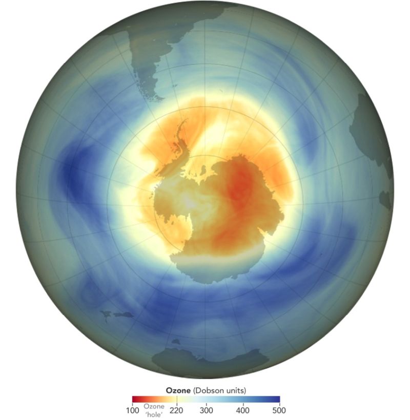
Scientists with NOAA and NASA have ranked this year’s ozone hole over the Antarctic as the fifth smallest since 1992 — the year that the Montreal Protocol, a landmark international agreement to phase out ozone-depleting chemicals began to take effect.
During the height of this year’s ozone depletion season from September 7 through October 13, the average extent of the 2025 ozone hole was about 7.23 million square miles (18.71 million square kilometers). The ozone hole is already breaking up nearly three weeks earlier than average over the past decade.
"As predicted, we're seeing ozone holes trending smaller in area than they were in the early 2000s," said Paul Newman, a senior scientist at the University of Maryland system and longtime leader of NASA’s ozone research team. "They're forming later in the season and breaking up earlier."
[ Back to Top ]
From NOAA National Environmental Satellite, Data, and Information Service
at https://www.nesdis.noaa.gov/news/2025-atlantic-hurricane-season-marked-high-powered-storms-no-us-landfalling-hurricanes
November 25, 2025
The 2025 Atlantic hurricane season, which officially ends on November 30, showcased near-normal activity, marked by periods of very strong storms. The season fell within the predicted ranges for named storms, hurricanes, and major hurricanes issued by NOAA’s Climate Prediction Center in the August Outlook.
The Atlantic basin produced 13 named storms (winds of 39 mph or greater), of which five became hurricanes (winds of 74 mph or greater) and four intensified to major hurricanes with winds reaching 111 mph or greater. No hurricanes made landfall in the continental U.S. for the first time since 2015. An average season has 14 named storms, seven hurricanes, and three major hurricanes.
The Atlantic season was notable for its striking contrast — wavering between periods of relative calm and bursts of intense activity, generating very powerful storms. While the climatological peak of the hurricane season (September 10) was quiet with no tropical activity, the season as a whole generated three Category 5 hurricanes.
See the original article at https://www.nesdis.noaa.gov/news/2025-atlantic-hurricane-season-marked-high-powered-storms-no-us-landfalling-hurricanes with links to more about the 2025 Atlantic hurricane season and how NOAA satellites help us study hurricanes.
[ Back to Top ]
From NASA Jet Propulsion Laboratory
at https://www.nasa.gov/missions/mars-reconnaissance-orbiter/nasa-orbiter-shines-new-light-on-long-running-martian-mystery/
November 25, 2025
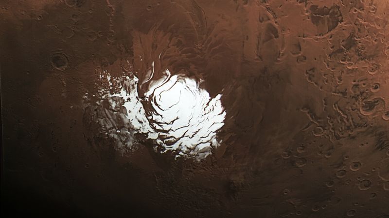
Results from an enhanced radar technique have demonstrated improvement to sub-surface observations of Mars.
NASA's Mars Reconnaissance Orbiter (MRO) has revisited and raised new questions about a mysterious feature buried beneath thousands of feet of ice at the Red Planet’s south pole. In a recent study, researchers conclude from data obtained using an innovative radar technique that an area on Mars suspected of being an underground lake is more likely to be a layer of rock and dust.
The 2018 discovery of the suspected lake set off a flurry of scientific activity, as water is closely linked with life in the solar system. While the latest findings indicate this feature is not a lake below the Martian surface, it does suggest that the same radar technique could be used to check for subsurface resources elsewhere on Mars, supporting future explorers.
[ Back to Top ]


From NOAA National Environmental Satellite, Data, and Information Service
at https://www.nesdis.noaa.gov/news/noaa-satellites-inform-warning-the-texas-hill-country-floods
September 30, 2025
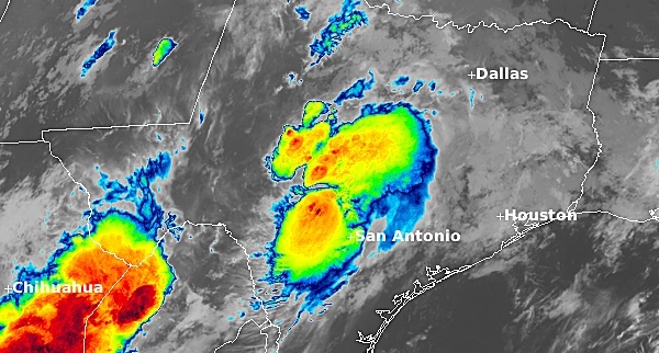
In the early hours of July 4, 2025 a devastating flash flood occurred in the Central Texas Hill Country. The Guadalupe River in Kerr County rose over twenty feet in just a few hours, and more than a hundred people lost their lives and thousands of residents' homes were destroyed.
Most flash floods are caused by slow-moving thunderstorms which move over the same area one right after the other. Flash floods develop over a short time period, making them life threatening. Areas most susceptible to flash flooding are mountainous streams, urban areas, low-lying areas, storm drains, culverts and rivers.
[ Back to Top ]
From NOAA News & Features
at https://www.noaa.gov/news-release/noaas-transformative-flood-inundation-mapping-expands-to-60-of-us
September 3, 2025
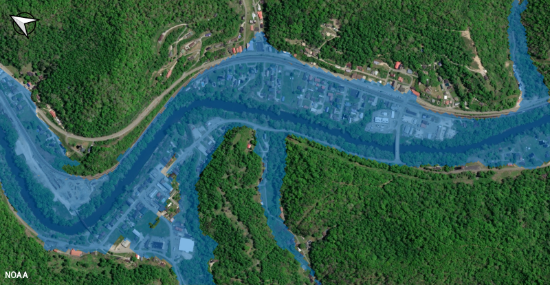
Today, NOAA’s National Weather Service (NWS) announced that the groundbreaking experimental Flood Inundation Mapping (FIM) tool has expanded significantly to serve 60% of the U.S. population, up from 30% the previous year.
The FIM provides near-real-time, high-resolution, street-level visualizations of flood waters to assist NWS forecasters in issuing flood watches and warnings. FIM services are now available to twice as many NWS weather forecast offices with new coverage for:
"Flooding is the most frequent severe weather-related threat, and our costliest natural disaster," said David Vallee, director, Service Innovation and Partnership Division, NOAA’s National Water Center. "Expanding our FIM availability has been a game-changer in providing actionable, real-time information to emergency and water resource managers, and will expand the delivery of impact-based decision support services to our core partners who work to keep Americans safe and informed."
[ Back to Top ]
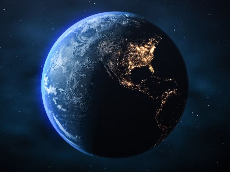
By Darren Orf, Popular Mechanics
at https://www.popularmechanics.com/science/a68886478/earth-is-getting-darker/
October 9, 2025
Here’s what you’ll learn when you read this story:
Thanks to the Earth’s leisurely, 1,040-mile-per-hour spin, if two points are equidistant from our equator, they should get relatively equally warmed by solar radiation. But, of course, the reality isn't quite that simple.
A new NASA-backed study — relying on data from the Clouds and the Earth’s Radiant Energy System (CERES) satellite — suggests that the northern hemisphere (NH) is actually growing dimmer than the southern hemisphere (SH), and that could be a big problem as the world rushes to break the planet’s climate-change-induced fever.
[ Back to Top ]


From NOAA Research
at https://research.noaa.gov/noaa-and-partners-deploy-mini-ocean-robots-to-collect-hurricane-data/
September 3, 2025
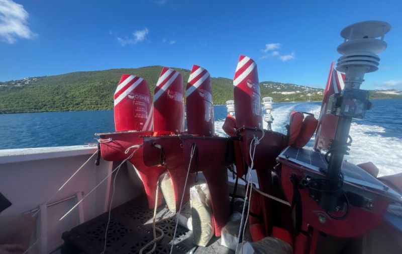
NOAA, in partnership with The University of Southern Mississippi and with the robotics company Oshen, launched five small uncrewed surface vehicles (USVs) called C-Stars in the waters off the U.S. Virgin Islands on August 31st to collect critical data to better understand hurricane development and activity. The deployment is the latest effort by NOAA to advance data collection to improve hurricane research and forecasting.
Two additional C-Stars are being stored in Gulfport, Mississippi, ready for launch ahead of actively developing storms in the Gulf this fall.
"Understanding weather conditions where the ocean surface meets the lower atmosphere is key to predicting hurricane intensity," said Greg Foltz, oceanographer for NOAA’s Atlantic Oceanographic and Meteorological Laboratory (AOML). "If these miniature uncrewed surface vehicles prove reliable, they could become a critical piece of NOAA’s hurricane observing system in the future."
[ Back to Top ]


In this issue, For Teachers brings you an exciting variety of resources. From a crater detection contest to citizen scientist opportunities, from equipment sources and guidelines to engaging student activities, there is surely something here for everyone.
By Bailey G. Light, NASA
at https://www.nasa.gov/directorates/stmd/prizes-challenges-crowdsourcing-program/center-of-excellence-for-collaborative-innovation-coeci/nasa-crater-detection-challenge/
November 25, 2025
Crater rims are vital landmarks for planetary science and navigation. Yet detecting them in real imagery is tough, with shadows, lighting shifts, and broken edges obscuring their shape.
This project invites you to develop methods that can reliably fit ellipses to crater rims, helping advance future space exploration.
In the pursuit of next generation, terrain-based optical navigation, NASA is developing a system that will use a visible-light camera on a spacecraft to capture orbital images of lunar terrain and process the imagery to:
The focus of this project is the crater detection process.
Natural imagery varies significantly in lighting and will impact the completeness of crater rims in the images.
Award: $55,000 in total prizes
Open Date: November 25, 2025
Close Date: January 19, 2026
For more information, visit: https://www.topcoder.com/nasa-crater-detection.
Teachers might also consider one or more activities from the four-part Impact Craters unit available from the SEA Lesson Plan Library.
[ Back to Top ]
By NASA Science Editorial Team
at https://science.nasa.gov/learning-resources/science-activation/nasa-globe-connect-people-land-and-space/
November 25, 2025
A group of elementary-aged students gather outside of Oldham County Public Library in La Grange, Kentucky, United States to look at clouds in the sky. "If anyone asks what you are doing, tell them, 'I am a citizen scientist and I am helping NASA,'" Children’s Programming Librarian, Cheri Grinnell, tells the kids. Grinnell supports an afterschool program called Leopard Spot where she engages K-5 students in collecting environmental data with the GLOBE (Global Learning & Observations to Benefit the Environment) Program.
"One little boy really got excited about that, and I heard him tell his mom he was working for NASA as they were leaving," says Grinnell. That idea is reinforced when the program receives an email from NASA with satellite data that align with the cloud data the students submitted. "I forwarded the NASA satellite response to the after-school coordinator, and she read it to them. That really excited them because it was evidence this is the real deal."
Learn to use GLOBE Observer HERE.
Find out more about NASA Science Activation HERE.
[ Back to Top ]
By NASA Science Editorial Team
https://science.nasa.gov/learning-resources/science-activation/new-nasa-heat-and-my-nasa-data-resources-bring-space-weather-science-into-classrooms/
November 24, 2025
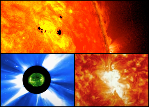
As the Sun enters a period of heightened activity, students now have a new way to explore its powerful effects on Earth and space. NASA’s Heliophysics Education Activation Team (NASA HEAT), in collaboration with My NASA Data, has released a new set of classroom resources that invite students and educators to engage with real NASA mission data to study space weather phenomena in real time.
Developed as part of NASA HEAT’s mission to increase awareness and understanding of heliophysics, these new materials help learners connect directly with the science of the Sun and its influence on the solar system. The resources include:
[ Back to Top ]
From American Radio Relay League, The National Association for Amateur Radio
at https://www.arrl.org/classroom-library-satellite-communications
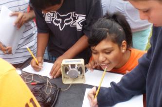
Bringing space into the classroom is an incredibly powerful learning experience for students. The marriage between wireless technology literacy and space literacy is a strong one that produces a portfolio of activities that can engage virtually all students at some ability and interest level.
The portfolio of activities can range from simply having a satellite prediction software package running in the back of the classroom on an old, salvaged computer, a simple receiver to collect telemetry data from orbiting satellites, to a full-up ground station to communicate with other hams via satellites, or even with the astronauts in the International Space Station through the ARISS (Amateur Radio on the International Space Station) program.
Teachers --> Check out this amazing array of activities, materials, and resources available for classroom instruction.
[ Back to Top ]
By Dr. Deborah Roberts-Harris, University of New Mexico and Ginger Butcher, Senior NASA Education Specialist
at https://assets.science.nasa.gov/content/dam/science/missions/aura/education/SCS-TeachersGuide.pdf
Last revised April 2016
Sensors, Circuit, and Satellites is a collection of classroom lessons created by NASA’s Aura mission education and outreach that explore the electromagnetic spectrum and NASA remote sensing instruments using student assembled circuits. These lessons integrate inquiry with active-learning experiences to engage students in the properties of electromagnetic energy and remote sensing. The investigations are sequenced to help the learner construct their knowledge about the electromagnetic spectrum while offering real world examples from NASA.
Includes four complete lessons
[ Back to Top ]
By NASA Science Editorial Team
at https://science.nasa.gov/get-involved/citizen-science/nasa-citizen-science-toolkit-for-librarians/
November 24, 2025
Our new Toolkit for Librarians can help you share NASA citizen science opportunities with your patrons and community members. Rural and urban libraries, informal educators, youth group leaders, and retirement community coordinators can all benefit from this resource. Together, we can open the door for more people to join the fun, learning, and thrill of doing NASA science.
The toolkit prepares a program leader to lead a NASA Science event for people ages 8 and up. The toolkit includes:
A Note from NASA...
NASA Citizen Science Toolkit for Librarians
Please share this toolkit -- or use it yourself -- to invite more people to do NASA science with us -- who knows what they will discover?!
[ Back to Top ]


On April 14, 2010 after a very small volcanic eruption a month earlier, Iceland's Mount Eyjafjallajökull exploded shooting more than 250 million cubic meters of earth into the atmosphere. Molten earth and ash were blown upwards with enough energy for them to reach an altitude of 9 kilometers (about 30,000 feet or a little more than 5.5 miles). The April eruption was categorized 4 on the Volcanic Explosivity Index, at least 10,000 times more materials sent 10-100 times higher than the small eruption on March 20. The volcano's latitude and wind conditions may have contributed to the formation of a cloud of abrasive glass-rich ash by erupting lava cooling faster than usual. Smaller eruptions continued through the month of May. In this activity, using images of remotely sensed satellite aerosol optical thickness data, learners will detect the position of the ash plumes from the volcano's eruptions and compare them to wind conditions. They will be able to monitor and report the movement of the ash plumes relative to population centers and air traffic in order to decide the safest way to respond to the eruption.
| Grade Level: | 6-12 (adaptable to 4-5) |
| Time Requirement: | 2 class periods |
| Prerequisites: | None |
| Relevant Disciplines: | Biology, Chemistry, Earth & Space Science, Geography |
[ Back to Top ]
Share your satellite-based lesson ideas with the teaching community.
Send us a complete lesson plan, or simply suggest a lesson idea. If you found the idea online, please share the source as well. The lesson can be about anything that helps connect learners with satellite-based technology - any grade level K-12 - any STEM subject area including geography.
Satellite-technology includes any part of the science, math, engineering, or technology of satellites, rockets, small-format satellites, and remote sensing instruments as well as the use of any environmental satellite data to explore questions related to aspects of global change and local impacts in the long term, short term, and catastrophic time frames. Of special interest are lessons providing opportunities for learners to inquire, experiment, and apply mathematics.
Perhaps you designed a lesson yourself - we will happily prepare it for future publication in More Lessons from the Sky and inclusion in the SEA's online Lesson Plan Library with full credit to the originating author(s). Perhaps you found a worthy lesson plan published elsewhere - we will do the research for possible inclusion in a lesson plan spotlight. In either case, you will receive full credit for developing and/or bringing the lesson to the attention of the teaching community. Don't forget to share your insights if you tried the lesson with students.
Please share your ideas at SEA.Librarian@SatEd.org.
[ Back to Top ]
![]()

This edition of the SEA Newsletter was produced in HTML5.
It is best viewed with most recent updates of Firefox, Edge, Chrome, Opera, or Safari.
©Satellite Educators Association, Inc. (SEA) https://SatEd.org SEA.Newsletter@SatEd.org
Satellite Educators Association, Inc. is a 501(c)(3) non-profit educational organization to which donations are tax deductible.
The SEA Newsletter is published quarterly in March, June, September, and December.
The SEA Newsletter is published on-line and available at no cost.
SEA terms, conditions, policies, and contact information are detailed HERE.
Unless otherwise listed, all photo and image credits are the authors of the articles.
Any opinons expressed in this Newsletter are those of the authors
and not necessarily those of the Satellite Educators Association, Inc.
or any of its officers, members, or representatives.
Many SEA Newsletter items contain third-party links to sites not governed by Satellite
Educators Association, Inc. The viewer is cautioned to be aware of the terms of use and
privacy policies for those third-party sites.
![]()

