
OUR VISION
The world's finest educators supporting science, technology, engineering, and math (STEM) learning for pre-kindergarten to post-graduate students using real-world applications from satellites and satellite data.
OUR MISSION
To enhance the education environment to excite students about science, technology, engineering, and math through space-based technology -- satellites and satellite data.

B. R. Ambedkar

When the United States aligns with dictatorships and totalitarian regimes, it compromises the basic democratic principles of its foundation -- namely, life, liberty and justice for all.
Benazir Bhutto

TABLE OF CONTENTS
Click a RED link to view article
ASSOCIATION NEWS
PRESIDENT'S CORNER
EARTH SYSTEM SCIENCE
JOHN'S JOURNEY
STEVE'S SPACE
A LOOK BACK
SATELLITES
ACCESS
ANALYZE
IN THE NEWS
For Teachers
More Lessons
from the Sky

April 11, 2025
In this issue, the top stories are the Southern California fires and the impact of federal budget proposals.
The PRESIDENT'S CORNER calls attention to detection of gravity waves from the International Space Station and their effect on weather patterns and space weather; Ron Gird's EARTH SYSTEM SCIENCE examines seeming climate anomalies with arctic outbreaks during an average warm winter; JOHN'S JOURNEY explores SmallSats in Career Technical Education; and STEVE'S SPACE continues space travel basics with spacecraft navigation and control.
A LOOK BACK shares a 65-year history of weather satellites and the Apollo 13 mission 55 years ago.
The SATELLITES section hails the operational status of GOES-19 as the new GOES East and progress toward the launch of NASA's IMAP (International Mapping and Acceleration Probe).
ACCESS includes the new publicly available GOES coronagraph data and the trove of rocks studied by the Mars Perseverance Rover;
ANALYZE offers flooding along the Ohio River monitored by NOAA satellites and a star's "swan song" captured by the Hubble space telescope.
APPLY highlights how NASA data is used to defend Earth from asteroids as well as the valuable applications of GOES satellites for 50 years.
IN THE NEWS reports the potential negative impact of White House budget proposals on both NASA Science and NOAA satellite upkeep.
FOR TEACHERS lists some funding opportunities for teachers in Career Technical Education and Environmental Literacy in addition to links for professional development events from NSTA and ESRI.
MORE LESSONS FROM THE SKY presents the latest update (July 2024) of the Wildfires from Space lesson module.
Enjoy!
--Editor

[ Back to Top ]

By Pete Arvedson, SEA Web Manager
April 1, 2025
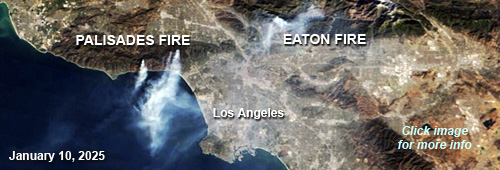
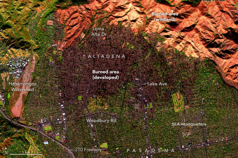
ALTADENA, CALIFORNIA--The headquarters office of the Satellite Educators Association in the Arvedson family home narrowly escaped burning during the Eaton Fire which began in the evening of January 7, 2025 about 1 mile northeast of SEA headquarters. All occupants of this neighborhood were evacuated the same evening. Driven by powerful Santa Ana winds (hurricane-force winds gusting to 130 mph [205 km/hour] and blowing from inland states towards the ocean through Southern California), the fire rapidly spread to neighboring communities, especially Altadena. By the end of the month, the fire had burned more than 14,000 acres (nearly 57 square kilometers), killed 18 people, and destroyed more than 9,000 buildings. The fire's southern extent in the middle of Altadena was just 1 short residential block north of SEA headquarters while other structures farther to the east and southeast were damaged or destroyed.
With electric power out, high Santa Ana winds randomly spreading burning embers, and the fire visible on the nearest mountains, the 3 occupants of the house along with 3 cats evacuated to area hotels for 19 days. Upon returning home, the inside of the house was essentially uninhabitable due to the toxic nature of the smoke and ash residue. All three occupants immediately contracted flu-like symptoms and were down for 2 weeks. It was mid February before the scheduled crews were able to clean all surfaces in the house. The occupants evacuated to another hotel for 5 days while 6 very large air scrubbers ran 24/7 in the house and the cleaners made the house livable again.
Smoke residue and ash was even found inside of the refrigerator/freezer in the kitchen. With the power out for several weeks and all food stored there spoiled, a special effort was necessary to clean the inside of the refrigerator/freezer before using it again. The SEA office also required special attention to cleaning and repairing or replacing the local network and all electronics in the office. April approached on the calendar before the office was ready for such things as publishing the Spring issue of the SEA Newsletter, normally posted March 1.
Located in the unincorporated area of Los Angeles County known as Altadena, SEA headquarters is in a postal zip code area assigned to the City of Pasadena, California, and consequently has a Pasadena mailing address. NASA Earth Observatory has AVIRIS-3 aerial imagery showing the fire extent. The reader is encouraged to visit NASA Earth Observatory at https://earthobservatory.nasa.gov/images/153821/eaton-fire-leaves-california-landscape-charred and https://earthobservatory.nasa.gov/images/153831/the-palisades-fires-footprint for more information.
[ Back to Top ]


By Simon Cracknell, President, Satellite Educators Association
In the classroom, I have recently been teaching my students (equivalent to 10th grade) about extreme weather, specifically typhoons that build in the Pacific and go on to hit countries like Philippines and Japan among others. It’s a common thing these days to see me engaged in a conversation with students about how we know what is happening in Earth’s upper atmosphere. I always tell them the same thing: Visit the SEA website (first) but feel free to explore what they can learn, from NASA and NOAA along with numerous other reliable sources.
I recently read about a (relatively) new tool being used on the International Space Station called the Atmospheric Waves Experiment (AWE) built to look directly down in the Earth’s atmosphere to study how gravity waves travel through the upper atmosphere. When I read the instrument had detected an anomaly 90 kilometers above the Earth’s surface that could influence weather patterns and space weather, it occurred to me that we were breaking new ground, which inevitably leads to new areas of study. This tool is designed to study atmospheric waves that occur in the mesosphere, a region of the atmosphere located between 50 and 90 km above the Earth and is difficult to study due to its extreme conditions, such as temperatures that can reach as low as -100°C.
The AWE sensor was able to capture data from the passage of Hurricane Helene over the United States in September 2023 and it detected unusual atmospheric waves in the mesosphere. What has been realised is that weather events like this on Earth, can have an impact on space weather and therefore affect any instruments we have working in space. The mesosphere plays a crucial role in maintaining the balance of atmospheric conditions, and any changes in this region may have a ripple effect on satellites in orbit. Since satellite trajectories are highly sensitive to changes in air density, even slight shifts in the mesosphere could cause problems.
The functions on our satellites that could most likely suffer disruptions are those related to communication and navigation. In an age when we are increasingly reliant on accurate and reliable technology, any effects of these mesospheric waves, even minor, can have significant impacts on numerous domestic technologies and beyond. I would be lost without a Sat-Nav in my car and the potential impact just on me would be noticeable, to say the least.
Fortunately, being able to detect these waves now, makes it easier for us to pre-empt their impacts using predictive models. These will allow us to improve the resilience of those satellite operations and limit the effects that these previously unknown phenomena can have.

Linking this back to my students in the classroom, the conversations always go back to the delicate balance in our planet’s systems, not just it’s atmosphere, but all of those systems and the interconnected nature of them. One of my roles as a department lead for Geography is to build interest in my subject, which in the current climate is easy. Thanks to the opportunities provided by various instruments in orbit and the dedicated personnel working with them, we are able to go through causes, impacts and solutions to much of what is happening in the world right now.
For more information about AWE, please see the following:
[ Back to Top ]

By Ron Gird, Meteorologist and former Satellite/Spaceflight and Outreach Program Manager for the National Weather Service
From NOAA News & Features at https://www.noaa.gov/news/despite-arctic-air-outbreaks-us-had-warm-dry-winter-on-average
March 10, 2025
A near-average February wrapped up a relatively warm and dry winter for the U.S., according to experts from NOAA’s National Centers for Environmental Information (NCEI).
Below are highlights from NOAA’s February 2025 U.S. climate report:
Meteorological winter (December 2024 – February 2025)
Meteorological winter across the contiguous U.S. had an average temperature of 34.1 degrees F — 1.9 degrees above average — ranking in the warmest third of NOAA’s historical record.
Total winter precipitation was 5.87 inches, 0.92 of an inch below average, ranking in the driest third of the December–February climate record.
February 2025
[ Back to Top ]


By John D. Moore, Executive Director, Institute for Earth Observations at Palmyra Cove, New Jersey
Consider three SmallSats: CubeSats, PocketQubes, and VLEO.
CubeSats, the pioneering small satellite format, have long been recognized as valuable tools for both research and education. Their modular design allows for rapid prototyping and iteration, making them ideal for student-led investigations in advanced Career Technical Education (CTE) programs. These satellites provide hands-on experience in coding, systems integration, telemetry, and high-altitude balloon testing, bridging the gap between classroom learning and real-world applications. The A3Sat initiative continues to evolve as an integral part of hands-on aerospace learning, with growing implementation across multiple educational institutions and international initiatives. The A3Sat project has successfully engaged students in real-world aerospace applications through collaborations at the Institute for Earth Observations, the US Naval Academy, the CubeSats in Peru Project, and DSST (Denver School of Science and Technology) schools in Colorado. Each of these programs highlights how small satellite technologies can be leveraged to build pathways into academic studies and future careers simply through exposing the students to these opportunities.
PocketQubes, with their compact 5 cm form factor, are revolutionizing space-based research and technology development. These tiny yet powerful platforms allow students to engage in authentic aerospace engineering challenges, from designing and assembling spacecraft components to testing them under real-world conditions.
Very Low Earth Orbit (VLEO) missions enable more precise data collection and lower latency communications, a step supported by NASA, opening a new frontier in the "New Space Ecosystem," VLEO is the altitude zone just below the International Space Station.
When considering implementation of any of these three approaches, the most prohibitive obstructions are cost and opportunities to "go to space." However, implementers must also consider the broader impacts such as the potential to benefit society and contribute to the achievement of specific societal outcomes. Even the National Science Foundation (NSF) requires unique and innovative proposals to document the proposal’s "Intellectual Merit." Broader impacts do not have to be unique with every proposal. What if there was a program, perhaps at the national level, that provided opportunities for such proposals to fulfill their "broader impact" requirement while contributing to the national science agenda set forth by White House Office of Science and Technology Policy, the National Academies of Science, or NSF? Seems like common sense to me.
A rapidly emerging frontier of the availability of low-cost sensors opens new opportunities in teaching the fundamentals of Remote Sensing. Using the Space to Earth: Earth to Space (SEES) Educational Model (from our Institute for Earth Observations) and the use of geospatial technologies, students can create "vertical profiles" using simple balloons, AEROKATS, drones, and high-altitude balloons. There are numerous opportunities through NASA and the GLOBE Program for students to make observations and measurements with satellites including LandSat, ICESat2, GPM, GOES, Terra, Aqua, CloudSat, TEMPO and others. Not a new concept to Satellite Educators Association (SEA), satellites have become integrated into so many aspects of our daily lives. They meet the future demands of both industry and government and national security. These types of hands-on, technical learning activities must begin at the precollege level--this is simply common sense. The continuing rapid evolution of aerospace technology and the increasing reliance on small satellites for commercial, environmental, and defense applications necessitate a workforce that is proficient in engineering, data science, and electronics from an early stage. By introducing SmallSat programs in middle and high school, students develop critical problem-solving skills, industry-specific competencies, and a deeper understanding of these STEM disciplines making decisions about their future before entering the workforce or higher education.
Expanding CTE initiatives to the precollege level ensures a steady pipeline of skilled individuals ready to fill positions in aerospace, satellite development, geospatial technologies and other high-tech fields. Early engagement also fosters innovation, allowing students to contribute meaningfully to cutting-edge research and development projects while still in school. Programs like A3Sat serve as a model for this approach, bridging educational pathways and workforce readiness through experiential learning. This is why it is critical that SEA continues to support the SmallSat Education Conference, whose focus is on precollege students and programming.
CTE programs have equipped students with the technical skills and practical knowledge essential for high-tech careers. As a proficiency- and competency-based learning model, CTE ensures students' progress by demonstrating mastery of industry-relevant skills rather than simply completing course work and fulfilling standards and testing. Small satellite technology provides an engaging platform for students to apply aerospace, electronics, and data science skills in real-world contexts. Key components include:
The creation and foundation of the Satellite Educators Association can be summarized in the A3 Model — Acquire, Analyze, and Apply. At first the educational endeavors centered on building antennas to receive and capture satellite direct read-out imagery. Over four decades they evolved to integrating satellite remote sensing imagery, data, and developing technologies into educational settings. By adhering to this framework, students have learned to obtain Earth observations, imagery, data, and how to process and interpret it. This structured approach ensures that satellite education remains relevant, practical, and aligned with both industry and government needs. The Satellite Educators Association further strengthens these efforts by providing a platform for educators and students to engage in collaborative projects that enhance technical proficiency and workforce readiness. Not sure how to do this? Check out More Lessons from the Sky, the online SEA Lesson Plan Library, and Using Satellites in Education – both freely available at https://SatEd.org.
The integration of small satellite technology into Career and Technical Education programs is reshaping STEM education by providing students with valuable hands-on experiences that directly align with industry needs. The A3 Educational Model — Acquire, Analyze, Apply — offers a structured approach for students to gain, refine, and implement their knowledge in real-world applications. As initiatives like A3Sat continue to develop, they will play a critical role in broadening participation in the space industry and shaping the future of both CTE and STEM education.
Don’t forget to celebrate the 30th Anniversary of the GLOBE Program in April 2025!
...and remember..."you can teach anything with satellites."
Stay safe - stay well
For now, I'm John ... and this is my journey.
[ Back to Top ]


By Steve Mills, Retired Systems Engineering Scientist; owner and Chief Engineer of Polymath Geo
In my last column I discussed how Newton’s Laws determine the orbit of a spacecraft, and how these laws are used to control its trajectory. My assumption, however, is that whoever or whatever is controlling the satellite knows where it is and how it is moving. Specifically, the controller must know:
Here I will discuss how spacecraft navigation and control is done in space travel.
Since ancient times, mariners have used the Sun, the Moon and the stars to navigate the oceans of the world. In the northern hemisphere, latitude can be known by measuring the angle from the horizon to the North Star, Polaris. Determining longitude is more complicated, and requires an absolute time reference along with the position of at least one other star (including the sun). These same principles apply to celestial navigation for a satellite.
There are at least three types of sensors that make celestial navigation possible: star trackers, horizon sensors and sun detectors. All of these are basically telescopic cameras that determine the angle to the object by measuring the offset of the image from the center of the field of view. Before launch, each device is calibrated to determine the angle at which the camera is pointed. A star tracker may be able to track several stars at the same time, and if the angles of at least two stars are known, the orientation of the satellite can be determined. Of course, a star tracker can also image planets or even the moon and use those angles for orientation. Because the sun is so bright, the sun detector does not even need a lens and can be a simple pinhole camera. A horizon detector requires multiple cameras to determine where the Earth is with respect to the satellite. It can be used to determine the altitude and to orient the zenith (straight up), and the nadir (straight down). It requires at least three cameras spaced 120 degrees apart or four cameras spaced 90 degrees (see Figure 1). Because on the Earth's dark side the horizon may be too dark to be seen, some horizon detectors use infrared cameras because in the infrared even at night the dark earth is much brighter in thermal energy than the cold background of space.

Once all the information about the measured angles of the sun, stars, planets and earth horizon are collected, the satellite controller compares these with the known angles of each and translates this information into the actual location and orientation of the satellite. At one time the navigator on a ship would use a nautical or astronomical almanac to determine this, but satellite controllers today have all this information in computers with algorithms to determine location and orientation.
A key part of celestial navigation is knowing the universal coordinated time (UTC) , which is a time reference that is not adjusted for local times zones and is based on atomic clocks and is broadcast across the globe. Modern timepieces such as a quartz crystal clock are accurate to within a few tenths of a second per day. If these on-board clocks are regularly synchronized using the UTC signals, then the satellite clock can measure universal time to within a few milliseconds. One millisecond of time uncertainty corresponds to about half a millimeter of satellite position error. This accuracy would amaze those ancient mariners who were happy if their navigation was within 100 kilometers.
Imagine that you are kidnapped, tied up, blindfolded and put in the back of a van with no windows. The kidnappers then drive the van to their headquarters. You can feel as it accelerates or slows down. You can also feel the centrifugal force as it rounds corners, and you know which directions it is turning. You remember all of this as best you can. While you are still tied up, the kidnappers then drive from their headquarters to another location to collect a ransom and then release you. If you remember everything that you feel, and afterwards, you describe that to the police detective, could the detective figure out where the kidnapper’s headquarters is just from what you felt in the van? In theory, at least, it is possible, using a process called dead reckoning.
Dead reckoning requires information about all the forces of acceleration or rotation experienced over a period of time. Acceleration creates an equal and opposite force, so that, for example, we feel pushed back into our seats when a vehicle is accelerating and pushed forward when slowing down. Rotation creates an apparent centrifugal force outward from the center of rotation. An estimate of the velocity at every point on a path can be determined by multiplying the acceleration by the period over which it occurs. Then the velocity multiplied by the time period gives the distance traveled.
In real life the detectives would probably not be able to determine the kidnappers' headquarters very well because human beings are not very good at estimating the forces of acceleration or rotation. There are, however, devices called accelerometers that give very accurate measurements. Any device that can measure force or pressure can be used as an accelerometer. The simplest accelerometer is a spring connected to a mass. Using Hooke's law, the force is determined by the length that the spring is stretched or compressed. Dividing the force by the mass gives acceleration. More advanced accelerometer technologies are piezo-electric devices, electro-magnetic transducers and lasers.
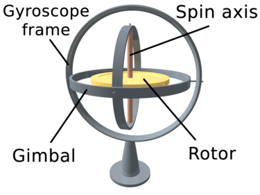
To measure rotation, multiple accelerometers can be oriented along a three-dimensional axis system to measure the centrifugal forces along those axes. Another method for measuring rotation is a gyroscope (see Figure 2). A gyroscope is a spinning rotator on a gimbal. The gimbal works so that the orientation of the axis of rotation is unaffected by tilting or rotation of the mounting. This is because of the law of conservation of angular momentum. The axis of the spinning wheel, therefore, can be used as a reference for measuring the orientation of a satellite. If, for example, the spin axis is pointed toward Polaris, the North Star, it will continue to point toward Polaris even if the satellite itself is spinning.
An Inertial Navigation System (INS) takes all the information from its accelerometers and gyroscope(s), feeds it into a computer dead reckoning algorithm, which determines the path of the satellite and its orientation. The problem with dead reckoning is that as time goes on it becomes less accurate. In our story, if the kidnappers were smart, they would drive a long journey with many stops and turns and accelerations to confuse the victim. So even with the most precise measurements, errors accumulate over time.
Dead reckoning does require that the starting point, ending point or some intermediate point be known absolutely. So, in the case of the kidnapping, the location of the kidnapping and the location of the random pickup would be known. For spacecraft, dead reckoning would require occasionally using some other method such as celestial navigation to determine the path and orientation.
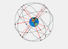
In the 21st century we all know exactly where we are by checking the mapping app on our cell phone or other device. These apps all use the Global Positioning System (GPS) to determine the exact latitude, longitude and altitude of the device. You may have a vague awareness that the GPS signal comes from a satellite, but most people don't know exactly how it works. So here I will try to give a simple explanation.
The GPS program originally began in the 1970’s as a US military program and became fully operational in 1993. To determine a position, a device needs to pick up a signal from at least four GPS satellites. The entire GPS constellation has at least 24 satellites orbiting Earth, with the orbits so arranged so that at least four are overhead at all times for every place on the Earth (see Figure 3). Each GPS satellite has a very accurate atomic clock onboard, and time is key to understanding how the system works. Each GPS satellite signal encodes the exact time it is transmitted along with its position in space. The receiver uses the time delay in the signal multiplied by the speed of light to determine the distance when the signal was transmitted. The signal also encodes its position, so with the four distances the receiver uses geometry to triangulate its position. Students who know their geometry may ask why three GPS satellite signals are not sufficient (as the word "triangulate" implies). The fourth signal is needed because most GPS receivers don't have atomic clocks, so it provides an exact time reference.
Each of the GPS satellites must know its own position, and it determines this by referencing the distance to the other GPS satellites in the constellation. The atomic clock on each GPS satellite is extremely accurate, but the GPS computations still require corrections for General Relativity, Special Relativity and the effect of the atmosphere on the speed of light. With these corrections GPS gives very precise measurements of satellite position, but it does not provide any information on its orientation. However, with at least three GPS receivers on a spacecraft an approximate orientation could be determined, but it would not be as accurate as that from a celestial navigation system.
Imagine a weather satellite with a camera that can be pointed to various places on the Earth’s surface to collect images of important meteorological events. The camera rotates clockwise to image a hurricane over the Atlantic. Because of the law of conservation of angular momentum, the body of the satellite will start rotating in the opposite direction, counterclockwise. The Attitude Control System stabilizes the satellite using a set of at least three flywheels that rotate to counteract any unintended rotation around each axis. The system is constantly monitoring the orientation using the INS, celestial navigation or both. Based on these, it spins the flywheels to proper speed to stabilize the satellite.
In my previous column I described how thrusters are used to make adjustments to spacecraft orbits. Usually, the spacecraft orientation will change during these orbital corrections, so attitude control and orbital control are performed simultaneously. The integrated system, including any celestial navigation, INS, GPS and Attitude Control, is called the Attitude and Orbit Control System (AOCS). The system may have redundancy for attitude or position, for example GPS and celestial navigation both give position. This redundancy is desirable if, for example, one of the systems stop working. There is concern that GPS signals could be jammed by hostile forces. In such a case the satellite could still operate using celestial navigation or the INS.
In my next column I will consider how the mission of a space program effects the design of the system. For example, how does a weather satellite mission differ from a communications satellite mission? How are they similar? How does a mission to put a human in space differ from putting a robot in space? How are military satellites different from civil space satellites? Is space tourism realistic?
[ Back to Top ]


From NOAA's National Environmental Satellite, Data, and Information Service
at https://www.nesdis.noaa.gov/news/celebrating-65-years-of-the-worlds-first-weather-satellite
April 1, 2025
On April 1, 1960, the National Aeronautics and Space Administration (NASA) launched TIROS-1, the world’s first successful meteorological satellite.
Nearly 68 years ago, on October 4, 1957, the former Soviet Union launched Sputnik 1, the first artificial satellite to be successfully placed in orbit around Earth. This feat ushered in the Space Age and sparked a space race between the United States and its Cold War rival.
This scramble for spaceflight superiority led to the establishment of our nation’s early space programs, and to the launch of Explorer-1 in 1958, the first operational U.S. satellite.
The United States’ earliest attempts to see Earth’s weather from space also began in the 1950s. Several experimental programs were developed and, by 1959, a pioneering weather exploration mission made its way to space onboard the Explorer VII satellite.
[ Back to Top ]
By Monika Luabeya, NASA
at https://www.nasa.gov/image-article/apollo-13-launch-55-years-ago/
April 11, 2025
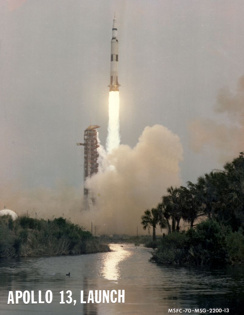
NASA astronauts Jim Lovell, Fred Haise, and Jack Swigert launch aboard the Apollo 13 spacecraft from NASA’s Kennedy Space Center in Florida on April 11, 1970. The mission seemed to be going smoothly until 55 hours and 55 minutes in when an oxygen tank ruptured. The new mission plan involved abandoning the Moon landing, looping around the Moon and getting the crew home safely as quickly as possible. The crew needed to go into "lifeboat mode," using the lunar module Aquarius to save the spacecraft and crew. On April 17, the crew returned to Earth, splashing down in the Pacific Ocean near Samoa.
[ Back to Top ]


From NOAA News & Features
at https://www.noaa.gov/news-release/noaas-goes-19-satellite-now-operational-providing-critical-new-data-to-forecasters
April 7, 2025
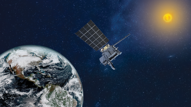
NOAA’s GOES-19 satellite, the latest and final satellite in NOAA’s GOES-R Series, officially began operations as GOES East today. This milestone comes after its June 25, 2024 launch, and subsequent post-launch testing of its instruments, systems and data.
GOES-19 replaces GOES-16 as GOES East, positioned 22,236 miles above the equator at 75.2 degrees west longitude. GOES-16 will now become a backup for NOAA’s operational geostationary constellation, maintaining its operational readiness for future use, if needed.
"With GOES-19 now in operation, NOAA has delivered the full fleet of GOES-R satellites to orbit, providing the most sophisticated technology ever flown in space to help forecast weather on Earth," said Stephen Volz, Ph.D., assistant administrator for NOAA’s Satellite and Information Service. "GOES-19 supports NOAA’s mission to provide secure and timely access to global environmental data and information to promote and protect the nation's security, environment, economy and quality of life."
In its new role, GOES-19 will serve as NOAA's primary geostationary satellite for much of the Western Hemisphere. It will track hurricanes and tropical storms in the Atlantic ocean basin, as well as monitor severe weather, atmospheric rivers, wildfires, volcanic eruptions and other environmental events affecting the contiguous U.S.
[ Back to Top ]
By Beth Ridgeway, NASA
at https://www.nasa.gov/centers-and-facilities/marshall/nasas-imap-arrives-at-nasa-marshall-for-testing-in-xrcf/
April 11, 2025
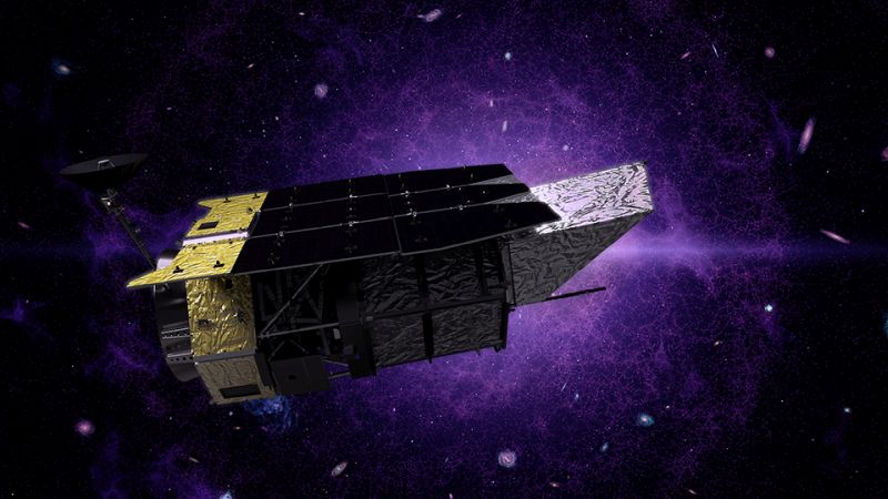
On March 18, NASA’s IMAP (Interstellar Mapping and Acceleration Probe) arrived at NASA’s Marshall Space Flight Center in Huntsville, Alabama, for thermal vacuum testing at the X-ray and Cryogenic Facility, which simulates the harsh conditions of space.
The IMAP mission is a modern-day celestial cartographer that will map the solar system by studying the heliosphere, a giant bubble created by the Sun’s solar wind that surrounds our solar system and protects it from harmful interstellar radiation.
Testing performed in the X-ray and Cryogenic Facility will help to assess the spacecraft before its journey toward the Sun. The IMAP mission will orbit the Sun at a location called Lagrange Point 1 (L1), which is about one million miles from Earth towards the Sun. From this location, IMAP can measure the local solar wind and scan the distant heliosphere without background from planets and their magnetic fields. The mission will use its suite of ten instruments to map the boundary of the heliosphere, analyze the composition of interstellar particles that make it through, and investigate how particles change as they move through the solar system.
[ Back to Top ]


From NOAA's National Environmental Satellite, Data, and Information Service
at https://www.nesdis.noaa.gov/news/noaas-latest-goes-satellite-releases-new-publicly-available-coronagraph-data
March 19, 2025
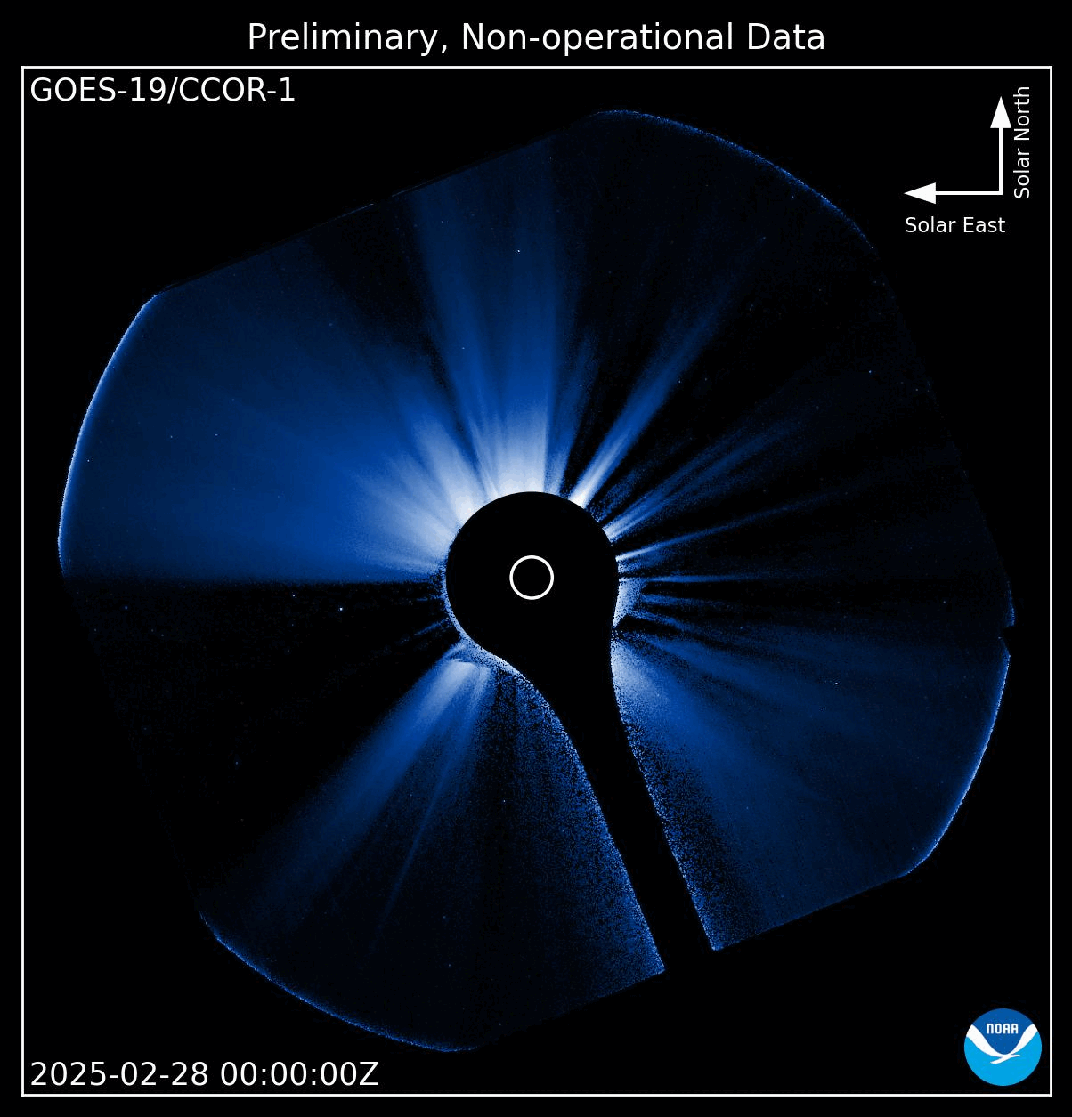
Near real-time preliminary data from NOAA’s first Compact Coronagraph (CCOR-1), a powerful solar telescope onboard the GOES-19 satellite, are now publicly accessible. GOES-19, launched in June 2024, began providing the new data through the Space Weather Prediction Center (SWPC) website as of February 25, 2025, and from the National Centers for Environmental Information (NCEI) archive starting March 7, 2025.
CCOR-1 was designed to continuously monitor the faint outermost layer of the sun’s atmosphere, called the corona, to detect large, fast-moving plasma eruptions called coronal mass ejections (CMEs). As the first modern coronagraph for space weather forecasting, CCOR-1 will provide the primary observations used to predict impending geomagnetic storm conditions, allowing SWPC to issue improved watches and warnings one to three days in advance. This gives operators critical lead time to take precautionary actions to protect vital infrastructure, economic interests and national security.
Space weather events like CMEs can disrupt power grids, satellite operations, radio communications, and GPS navigation. Forecasts based on CCOR-1 images are critical for power grid managers so they can take preventive measures to ensure that power flows smoothly and to prevent transformer failures. Additionally, SWPC uses CCOR-1 data and imagery to develop watches and warnings that are invaluable to industries ranging from commercial aviation to precision agriculture, oil and gas exploration, and even national defense among others.
[ Back to Top ]
From NASA Jet Propulsion Laboratory
at https://www.nasa.gov/missions/mars-2020-perseverance/perseverance-rover/nasas-perseverance-mars-rover-studies-trove-of-rocks-on-crater-rim/
April 10, 2025
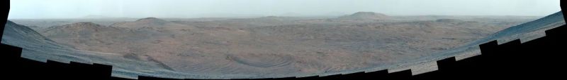
The diversity of rock types along the rim of Jezero Crater offers a wide glimpse of Martian history.
Scientists with NASA’s Perseverance rover are exploring what they consider a veritable Martian cornucopia full of intriguing rocky outcrops on the rim of Jezero Crater. Studying rocks, boulders, and outcrops helps scientists understand the planet’s history, evolution, and potential for past or present habitability. Since January, the rover has cored five rocks on the rim, sealing samples from three of them in sample tubes. It’s also performed up-close analysis of seven rocks and analyzed another 83 from afar by zapping them with a laser. This is the mission’s fastest science-collection tempo since the rover landed on the Red Planet more than four years ago.
Perseverance climbed the western wall of Jezero Crater for 3½ months, reaching the rim on Dec. 12, 2024, and is currently exploring a roughly 445-foot-tall (135-meter-tall) slope the science team calls “Witch Hazel Hill.” The diversity of rocks they have found there has gone beyond their expectations.
"During previous science campaigns in Jezero, it could take several months to find a rock that was significantly different from the last rock we sampled and scientifically unique enough for sampling," said Perseverance’s project scientist, Katie Stack Morgan of NASA’s Jet Propulsion Laboratory in Southern California. "But up here on the crater rim, there are new and intriguing rocks everywhere the rover turns. It has been all we had hoped for and more."
[ Back to Top ]


From NOAA's National Environmental Satellite, Date, and Information Service
at https://www.nesdis.noaa.gov/news/noaa-satellites-help-show-historic-flooding-along-ohio-river
April 10, 2025
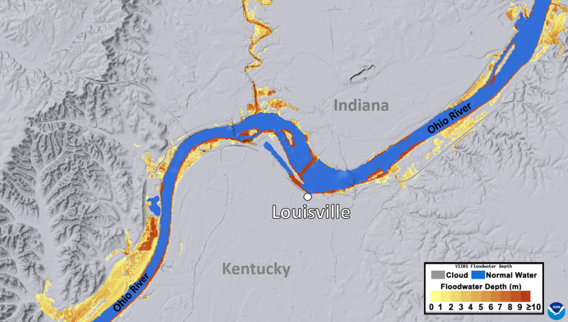
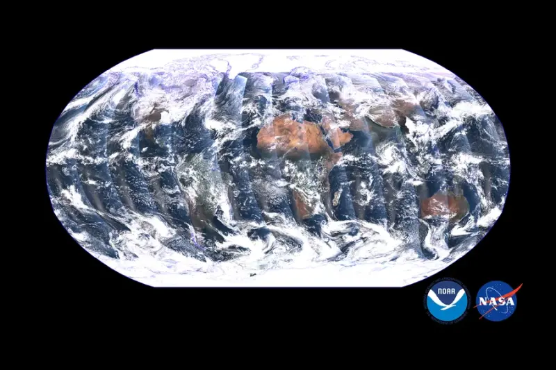
This imagery of the Ohio River Valley shows the extent and depth of the river flooding around the Louisville, Ky., metropolitan region from earlier this week. This image was taken on April 7, 2025, during a period of clear skies after several days of very heavy rain fell across the Ohio Valley.
The legend on the lower-right indicates the various depths of flooding along the river, in meters. The yellow and orange shading indicates several meters of water, with red showing total water depths of more than 9 meters (~30 feet).
[ Back to Top ]
From NASA Hubble Mission Team, Goddard Space Flight Center
at https://research.noaa.gov/no-sign-of-fossil-fuel-pollution-peak-as-the-world-falls-further-behind-climate-targets/
April 11, 2025
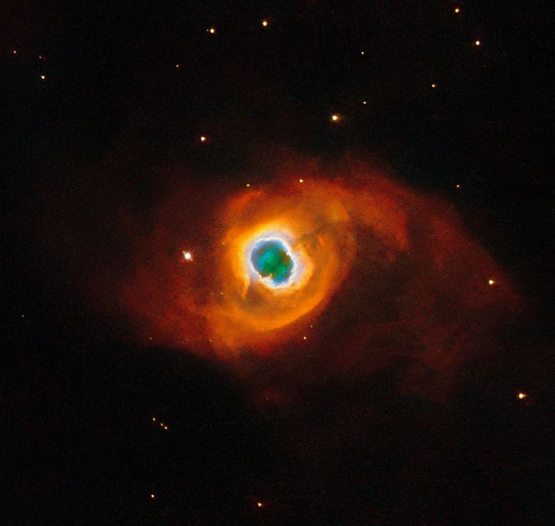
The swirling, paint-like clouds in the darkness of space in this stunning image seem surreal, like a portal to another world opening before us. In fact, the subject of this NASA/ESA Hubble Space Telescope image is very real. We are seeing vast clouds of ionized atoms thrown into space by a dying star. This is a planetary nebula named Kohoutek 4-55, a member of the Milky Way galaxy situated just 4,600 light-years away in the constellation Cygnus (the Swan).
[ Back to Top ]


By Lauren Leese, NASA
at https://science.nasa.gov/open-science/planetary-defense-asteroids/
April 10, 2025
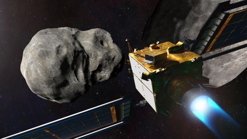
The asteroid 2024 YR4 made headlines in February with the news that it had a chance of hitting Earth on Dec. 22, 2032, as determined by an analysis from NASA’s Center for Near Earth Object Studies (CNEOS) at the agency’s Jet Propulsion Laboratory in Southern California. The probability of collision peaked at over 3% on Feb. 18 — the highest ever recorded for an object of its size. This sparked concerns about the damage the asteroid might do should it hit Earth.
[ Back to Top ]
From NOAA's National Environmental Satellite, Data, and Information Service
at https://www.nesdis.noaa.gov/our-satellites/currently-flying/geostationary-satellites/celebrating-50-years-of-goes
December 12, 2024
in 2025, NOAA celebrates 50 years of its heralded Geostationary Operational Environmental Satellite program, known as GOES. For five decades, NOAA and NASA have partnered to advance NOAA satellite observations from geostationary orbit. GOES are our sentinels in the sky: keeping constant watch for severe weather and environmental hazards on Earth and dangerous space weather.
For 50 years, GOES data has been the backbone of short-term forecasts and warnings of severe weather and environmental hazards in the Western Hemisphere and forecasts and warnings of space weather hazards. Each successive generation of GOES has brought improvements and new capabilities to monitor our part of the world.
[ Back to Top ]


By Eric Burger, Ars Technica
at https://arstechnica.com/space/2025/04/trump-white-house-budget-proposal-eviscerates-science-funding-at-nasa/
This week, as part of the process to develop a budget for fiscal-year 2026, the Trump White House shared the draft version of its budget request for NASA with the space agency.
This initial version of the administration's budget request calls for an approximately 20 percent overall cut to the agency's budget across the board, effectively $5 billion from an overall topline of about $25 billion. However, the majority of the cuts are concentrated within the agency's Science Mission Directorate, which oversees all planetary science, Earth science, astrophysics research, and more.
[ Back to Top ]
By Scott Waldman & E&E News, Scientific American
at https://www.scientificamerican.com/article/amid-trump-cuts-noaa-halts-upkeep-of-critical-weather-satellites/
NOAA has begun to limit the work it devotes to maintaining a pair of polar weather satellites — putting at risk the accuracy of both weather forecasts and extreme storm predictions, say former agency officials.
The move, outlined in a memo obtained exclusively by POLITICO’s E&E News, calls on the agency to take a “minimum mission operations approach” to the two probes. The satellites are part of the Joint Polar Satellite System, which serves as the backbone of three- and seven-day forecasts and early warnings for hurricanes and tornadoes.
[ Back to Top ]


By NASA Science Editorial Team
at https://science.nasa.gov/learning-resources/science-activation/globe-mission-earth-supports-career-technical-education/
April 11, 2025
The NASA Science Activation program’s GLOBE Mission EARTH (GME) project is forging powerful connections between career technical education (CTE) programs and real-world science, inspiring students across the United States to pursue careers in Science, Technology, Engineering, and Mathematics (STEM).
GME is a collaborative effort between NASA scientists, educators, and schools that brings NASA Earth science and the GLOBE Program into classrooms to support hands-on, inquiry-based learning. GLOBE (Global Learning and Observations to Benefit the Environment) is an international science and education program that provides students and the public with the opportunity to participate in data collection and the scientific process, contributing meaningfully to our understanding of the Earth system.
By connecting students directly to environmental research and NASA data, GME helps make science more relevant, engaging, and applicable to students’ futures. In CTE programs — where project-based and work-based learning are key instructional strategies—GME’s integration of GLOBE protocols offers students the chance to develop not only technical skills, but also essential data literacy and professional competencies like collaboration, critical thinking, and communication. These cross-cutting skills are valuable across a wide range of industries, from agriculture and advanced manufacturing to natural resources and public safety.
[ Back to Top ]
From NOAA Office of Education, Environmental Literacy Program
at https://www.noaa.gov/office-education/elp/news/funding-opportunity-environmental-literacy-for-community-resilience-in-gulf
February 26, 2025
NOAA's Environmental Literacy Program is partnering with the National Academies of Sciences, Engineering, and Medicine’s Gulf Research Program (GRP) to enhance community resilience and increase the environmental literacy of community members across the U.S. Gulf States (Texas, Louisiana, Mississippi, Alabama, and Florida) through place-based education. With NOAA's support, GRP is offering a funding opportunity titled Environmental Literacy for Community Resilience for projects that educate community members on local environmental challenges, engage learners in solutions-oriented activities, and empower participants to engage in them.
[ Back to Top ]
The National Science Teachers Association offers many resources for teachers on a regular basis. Here are a few. If you want more about GIS, check out ESRI's Education Summit.
[ Back to Top ]


Wildfire is a global reality, and with the onset of climate change, the number of yearly wildfire is increasing. The impacts range from the immediate and tangible to the delayed and less obvious. In this activity, students assess wildfires using remote sensing imagery.
More Lessons from the Sky is pleased to spotlight this lesson develop by Natasha Stavros at NASA's Jet Propulsion Laboratory. The original problem set and all of its linked resources can be found at this URL: http://www.jpl.nasa.gov/edu/teach/activity/fired-up-over-math-studying-wildfires-from-space/.
The lesson addresses Next Generation Science Standards for grades 4 and 9-12 and Common Core State Standards for Mathematics in grades 3-12.
| Grade Level: | 3-12 |
| Time Requirement: | 1-2 class periods |
| Prerequisites: | None |
| Relevant Disciplines: | Science, Mathematics, Geography |
[ Back to Top ]
Share your satellite-based lesson ideas with the teaching community.
Send us a complete lesson plan, or simply suggest a lesson idea. If you found the idea online, please share the source as well. The lesson can be about anything that helps connect learners with satellite-based technology - any grade level K-12 - any STEM subject area including geography.
Satellite-technology includes any part of the science, math, engineering, or technology of satellites, rockets, and remote sensing instruments as well as the use of any environmental satellite data to explore questions related to aspects of global change and local impacts in the long term, short term, and catastrophic time frames. Of special interest are lessons providing opportunities for learners to inquire, experiment, and apply mathematics.
Perhaps you designed a lesson yourself - we will happily prepare it for future publication in More Lessons from the Sky and inclusion in the SEA's online Lesson Plan Library with full credit to the originating author(s). Perhaps you found a worthy lesson plan published elsewhere - we will do the research for possible inclusion in a lesson plan spotlight. In either case, you will receive full credit for developing and/or bringing the lesson to the attention of the teaching community. Don't forget to share your insights if you tried the lesson with students.
Please share your ideas at SEA.Librarian@SatEd.org.
[ Back to Top ]
![]()

This edition of the SEA Newsletter was produced in HTML5.
It is best viewed with most recent updates of Firefox, Edge, Chrome, Opera, or Safari.
©Satellite Educators Association, Inc. (SEA) https://SatEd.org SEA.Newsletter@SatEd.org
Satellite Educators Association, Inc. is a 501(c)(3) non-profit educational organization to shich donations are tax deductible.
The SEA Newsletter is published quarterly in March, June, September, and December.
The SEA Newsletter is published on-line and available at no cost.
SEA terms, conditions, policies, and contact information are detailed HERE.
Unless otherwise listed, all photo and image credits are the authors of the articles.
Any opinons expressed in this Newsletter are those of the authors
and not necessarily those of the Satellite Educators Association, Inc.
or any of its officers, members, or representatives.
Many SEA Newsletter items contain third-party links to sites not governed by Satellite
Educators Association, Inc. The viewer is cautioned to be aware of the terms of use and
privacy policies for those third-party sites.
![]()