

OUR VISION
The world's finest educators supporting science, technology, engineering, and math (STEM) learning for pre-kindergarten to post-graduate students using real-world applications from satellites and satellite data.
OUR MISSION
To enhance the education environment to excite students about science, technology, engineering, and math through space-based technology -- satellites and satellite data.

The saddest aspect of life right now is that science gathers knowledge faster than society gathers wisdom.
Isaac Asimov

TABLE OF CONTENTS
Click a RED link to view article
ASSOCIATION NEWS
JOHN'S JOURNEY
SATELLITES with ED
SATELLITES
ACCESS
ANALYZE
APPLY
A LOOK BACK
For Teachers
More Lessons
from the Sky

June 1, 2024
In this issue, the announcement of SEA's Annual Members Meeting leads the Association News section. Then there is a special congratulations to ESIP, an SEA Partner in Education, for 25 years of service.
The Satellites section brings us up to date on the GOES-U launch in June and NASA CubeSats scanning the Earth.
ACCESS includes a review of SEA tools for students' easy access to, and use of, remote-sensing data; NASA's new mission to study arctic sea ice melt; and imagery of thunderstorms (even tornadoes?) forming along a dry line.
ANALYZE highlights tornadoes and includes updates on the polar vortex and Juno's high-def views of Europa's ice shell.
APPLY offers information about fruit fly hosts used to study tumors and parasites in space; how pollen can change the weather; and a rundown of the COP-28 meeting in Dubai.
A LOOK BACK compares natural disasters, occurrence and cost, now with those 25 and 50 years ago.
FOR TEACHERS includes an offer for high school students to apply for NOAA's Young Changemakers Fellowship program (Hurry - the deadline is June 10!!) and the heart-grabbing story of a young boy's curiosity and his impact on NASA.
Ron Gird Hurricane Season Outlook), John Moore (A3Sat Education Goals), and Ed Murashie (How wWe Know About the Sun) continue their regular column offerings and More Lessons from the Sky brings an updated version of the lesson plan "What is a Tornado?"
Enjoy!
--Editor

[ Back to Top ]


Before the next edition of the SEA Newsletter, it will be time for the annual SEA Meeting of Members. The meeting will take place on ZOOM. The date and time of the meeting as well as log-in instructions will be emailed to all active members (members whose dues are current) before the meeting.
While the meeting is open to all interested persons, voice and vote at the meeting is reserved for active members only. Be sure your SEA membership dues are up to date to guarantee your voice and vote at the meeting. To check your membership status, click HERE or visit https://SatEd.org and click the Join Us button, then click the Check button.

[ Back to Top ]
Why should I renew now? SEA membership is annual running from August 1 to July 31 of the following year. For just $20 per year, membership in the Satellite Educators Association entitles you to voice and vote at the annual SEA Meeting during the summer as well as access to important members-only announcements.
If you are new to SEA or your membership has lapsed, renew now to receive up to two months membership for free.
To join SEA or renew your SEA membership, click HERE or visit https://SatEd.org and click the Join Us button. Then...New Members click JOIN, renewing members click RENEW.
For more details about SEA Membership, please review related sections of SEA's Terms and Conditions page.

[ Back to Top ]
SEA has been a member of Earth Science information Partners (ESIP)for the past 15 years, and ESIP is listed on SEA's Web site as a Partner in Education. ESIP serves the need to preserve and make available data from all Earth and Space Science endeavors. ESIP has evolved from a federation of partners to an organization of organizations including more than 170 partner organizations with room for more. SEA wishes ESIP hearty congratulations and thanks for a quarter century of service.
By Allison Mills and Susan Singledecker, ESIP
May 28, 2024
https://science.nasa.gov/uncategorized/earth-science-information-partners-celebrate-25-years-of-collaboration/
In 2023, the Earth Science Information Partners (ESIP) community celebrated 25 years since the nonprofit’s founding. Serving as a home for Earth science data and computing professionals, ESIP has evolved alongside the tools and vast expansion of Earth science data available now.
Building on the deep roots of collaboration that ground ESIP and honoring the 2023 Year of Open Science, the 2023 July ESIP Meeting’s theme focused on "Opening Doors to Open Science." Open science is a collaborative culture enabled by technology that empowers the open sharing of data, information, and knowledge within the scientific community and the wider public to accelerate scientific research and understanding. This definition of open science comes from the 2021 article on the topic published in Earth and Space Science. (To learn more about how open science is being implemented within the context of NASA’s Earth Science Division – see Open Source Science: The NASA Earth Science Perspective, in the September–October 2021 issue of The Earth Observer [Volume 33, Issue 5, pp. 5–9, 11].)
Participants from around the world gathered July 18–21, 2023, in Burlington, VT to explore this theme. One of the strengths of the ESIP community is how it brings people together from government agencies, academia, and industry to work toward common goals. Altogether, nearly 400 attendees from nearly as many institutions, spanning many technical domains and career stages, gathered for the 4-day meeting, which featured a hybrid format that allowed for both in-person participation and virtual access to all plenaries and breakout sessions. Some of the in-person attendees are shown in Photo 1.
This article begins with a brief section on the history and purpose of ESIP followed by a summary of the highlights from each day of the July 2023 meeting.

[ Back to Top ]


By Ron Gird, Meteorologist and former Satellite/Spaceflight and Outreach Program Manager for the National Weather Service
The El Niño conditions in the equatorial Pacific have faded and been replaced by a distinct La Niña. Accompanying this shift is increased likelihood of hurricanes in the North Atlantic. Are you ready? The following article from NOAA describes the predicted hurricane season (June 1 to November 1). The article includes links for tips on preparedness and safety. Enjoy. -- Ron
From NOAA News & Features
May 23, 2024
https://www.noaa.gov/news-release/noaa-predicts-above-normal-2024-atlantic-hurricane-season
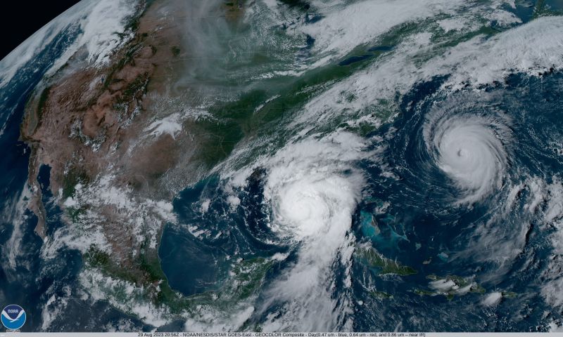
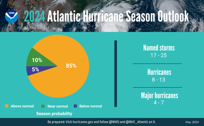
NOAA National Weather Service forecasters at the Climate Prediction Center predict above-normal hurricane activity in the Atlantic basin this year. NOAA’s outlook for the 2024 Atlantic hurricane season, which spans from June 1 to November 30, predicts an 85% chance of an above-normal season, a 10% chance of a near-normal season and a 5% chance of a below-normal season.
NOAA is forecasting a range of 17 to 25 total named storms (winds of 39 mph or higher). Of those, 8 to 13 are forecast to become hurricanes (winds of 74 mph or higher), including 4 to 7 major hurricanes (category 3, 4 or 5; with winds of 111 mph or higher). Forecasters have a 70% confidence in these ranges.
The upcoming Atlantic hurricane season is expected to have above-normal activity due to a confluence of factors, including near-record warm ocean temperatures in the Atlantic Ocean, development of La Nina conditions in the Pacific, reduced Atlantic trade winds and less wind shear, all of which tend to favor tropical storm formation.

[ Back to Top ]


By John D. Moore, Executive Director, Institute for Earth Observations at Palmyra Cove, New Jersey
The primary purpose of the A3Sat development is to provide an authentic experiential learning opportunity to students, many of whom might not have been previously exposed to space or, more specifically, satellite and remote sensing technologies. By engaging students in the complete life cycle of a CubeSat emulator project – from design and construction to data analysis – the A3Sat offers a hands-on, immersive experience that bridges the gap between theoretical knowledge and real-world application. The A3Sat is currently used as introductory academic exercises at several academic institutions including the United States Naval Academy. This experiential learning approach ensures that students gain a comprehensive understanding of satellite technology and its applications. It aims to demystify space and remote sensing, making these advanced topics accessible and exciting for a diverse group of learners. Through this authentic experience, students are able to grasp complex concepts more effectively as well as develop a genuine interest in aerospace and other STEM fields thus inspiring future academic and career pursuits.
The A3Sat was designed as a "disruptive technology" (or "disruptive innovation") for precollege STEM education. One of its major educational goals was to broaden participation in the satellite community. As CubeSats grew in providing an alternative satellite platform, research capabilities increased rapidly such that CubeSats are now an integral part of what the National Academies call a "New Space Ecosystem." A3Sat was developed to provide an authentic engineering and computer science experiential learning activity at an introductory level. Jin Kang of the United States Naval Academy described a three tiered pedagogical structure with A3Sat presented as the primary Tier 1 project in "Hardware Architecture for Evolutionary SmallSat Pedagogy and Space Workforce Development" in the Journal of Small Satellites (https://www.jossonline.com/storage/2023/02/Final-Kang-Hardware-Architecture-for-Evolutionary-SmallSat-Pedagogy-and-Space-Workforce-Development.pdf).
For the past several years, we at the Institute for Earth Observations at Palmyra Cove have worked with numerous schools and organizations in addition to the United States Naval Academy who piloted the A3Sat in middle school, high school, and college level settings.

In 2023, DSST Public Schools in Colorado initiated an innovative CubeSat program aimed at high school students, grades 9 to 12. The student CubeSat team built and successfully launched two A3Sats via high-altitude balloons (HABs). The sensors onboard and ground station worked perfectly and, quite frankly, beyond expectations. The program was so successful and generated so much student excitement and, DSST greatly expanded their program the following year. During the 2023-2024 school year, DSST incorporated CubeSat labs in three of its schools: Montview High School, Cedar High School, and Conservatory Green High School. The program involves building and launching A3Sat CubeSat Emulators on high-altitude balloons. It fulfills several educational initiatives and fosters a diverse and inclusive learning environment. The program introduced students to aerospace topics and equipped them with essential skills in telemetry, soldering, coding, 3D modeling, and project management under the mentorship of aerospace professionals. On May11, 2024, the three schools launched three HABs with a total of ten A3Sats that functioned perfectly up to altitudes of 100,000 ft. The culmination of a year’s work, students excitedly met for the launch, tracking, and recovery of the A3Sat payloads.
The students from DSST succeeded in achieving the three As of A3Sat: (1) ACQUIRE -- Students developed and completed a plan of action based on A3Sat and developed auxiliary payloads to be launched via a HAB; (2) ANALYZE -- Using the A3Sat Ground Station, students analyzed data from the HAB mission; and (3) APPLY --Based on these and other successes during the school year, students entered discussion about developing and incorporating specific payloads into next year’s A3Sat thus taking their work one step further. The students also set a goal of presenting their experiences at the 2024 Small Satellite Education Conference with an academic poster and accompanying presentation of their work.
These DSST student-centered teams working with each other and local mentors deserve our heartiest CONGRATULATIONS on their huge success! What a perfect way to end the school year!
A3Sat was earlier described as a "disruptive technology," an example of how educational initiatives can effectively be implemented to engage students in aerospace topics, promote diversity, and develop workplace readiness skills. Witness DSST Public Schools initiated a CubeSat program following the "CubeSats in Peru Project." The program provides a student-centered project that encompasses data analysis, teamwork, project management, and more. The program not only excites and inspires students but also lays the groundwork for future advancements in aerospace endeavors such as payload development. The program's success is evident in the students' enthusiasm and the comprehensive skills they acquired, setting a promising foundation for their future careers in aerospace related fields including presenting their project at an international conference. This completes an academic hierarchy of developing an idea or question, designing an instrument, collecting data, and presenting to a professional society as a poster, or presentation.
Speaking of the SmallSat Ed Conference, it's not too early to start planning to attend the 2024 conference at NASA’s Kennedy Space Center in October 2024 – for more information and/or to register, go to https://www.smallsateducation.org/.
I will be attending the 2024 GLOBE Program Annual Meeting in Fredonia, New York, July 15-18, 2024 - https://www.globe.gov/news-events/meetings_symposia/annual-meeting/. GLOBE will be celebrating their 29th anniversary. I will be presenting a poster on A3Sat and will host a Share-a-Thon joined by my colleagues representing ICESat2, NASA AEROKATS, and introducing the new Carbon Sensor tool. The GLOBE Satellite Education Team will gather as a follow-up to the North American Regional Meeting held here at the Institute for Earth Observations in March, to continue discussions and strategies for better infusing satellites and remote sensing into GLOBE. I will say that I find it remarkable that GLOBE struggles to embrace these initiatives as satellites and remote sensing will have a dramatic impact on our health of our planet, national security, and technological advancements that will impact society in the future.
Stay safe -- stay well!
For now, I'm John...and this is my Journey

[ Back to Top ]


By Edward Murashie, President, Pro-Engineered Solutions
In the Spring 2024 issue, Satellites with Ed began a look at the Sun and the role environmental satellites and spacecraft from Earth play in helping us understand the Sun's behavior. At that time, GOES Watches Over the Earth and Sun described the Sun's structure and how that structure creates phenomena unique to stars. In this Summer issue, How Do We Know So Much About the Sun? illuminates the role remote sensors on satellites in Earth-orbit and Earth-launched spacecraft have played in furthering our knowledge of the Sun.
One eventful observation was in September 1859 when astronomer Richard Carrington noticed a bright event while studying sunspot activity. Less than 24 hours later the Aurora Borealis was seen in low latitudes like never before and telegraph operators reported malfunctions and equipment damage. This became known as the Carrington Event.
It is for reasons like this that monitoring the Sun is critical. If this were to happen today without us being prepared we would not only endanger the astronauts in the space station, but also satellite, power grid, and radio transmissions. Knowing when a Coronal Mass Ejection, or CME, event is coming in our direction, the astronauts can shelter in a better shielded area of the space station, sensitive electronics can be shut down, and satellites can be reoriented. But this is not always the case.
In February 2022 SpaceX delivered a batch of Starlink satellites in low Earth orbit. Before their engines could raise their orbit, a solar storm hit them causing drag, lowering their orbit and eventually causing them to burn up in the atmosphere, an estimated 50 million dollar loss. On February 22nd this year near 58,000 ATT customers in America reported having trouble making phone calls over a 12-hour period. First reports questioned if it was a terrorist act. Soon after that, it was reported that sunspot AR3590 was associated with a X1.8 and X1.7 class solar flare the night before the outage. The question was then asked if these events could had caused the outage. Finally a day later ATT announced it was an application coding issue caused during an expansion of their network, mystery solved.
But that was not the case in May 2024 when nine X-Class solar flares ranging from X1.0 to X4.5 occurred between May 3rd and the May 9th emanating from sun spot clusters AR3663 and AR3664. X-Class flares are the highest ranking flares, with the most powerful recorded in 2003 with a rating of X17, although the sensor saturated so it is estimated to have been X45. Both the 2003 and 2024 flares lead to a G5 solar storm which is the highest storm ranking. Elon Musk of Starlink reported that Starlink satellites were under a lot of pressure from the storm but were holding up although had “degraded service” but ultimately remained operational. Other services, including: Sirius XM radio, Amazon Web Services (AWS), Target, and the United States Postal Service to name a few were also affected. But along with the bad news was good news such as being able to see the aurora as far south as Florida, something not seen since 1989. Before AR3664 rotated out of view, it still had one spectacular display on May 14th at the Sun’s limb, with an X8.7 solar flare. With AR3664 to be on the same size scale as the Carrington sunspot, who knows what would have happened had it been pointed at the Earth.

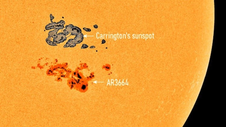
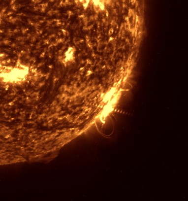
Even though AR3664 was visible using proper solar glasses, if you happened to be in the right location on April 8, 2024, the glasses were better used to observe the total solar eclipse. The path of totality stretched over Mazatlán, Mexico; Dallas, Texas; Buffalo, New York; and parts of Eastern Canada including New Brunswick, and Newfoundland.

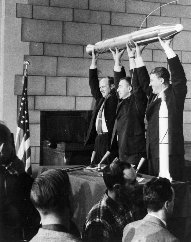
Satellites play a pivotal role in solar research and monitoring. In 1958, America developed and launched their first satellite: Explorer 1. It was equipped with a cosmic ray detector which detected varying amounts of charged particles as the satellite orbited in a highly elliptical orbit. These charged particle bands were named after the project Chief Scientist, James Van Allen. Plasma and charged particles radiate from the sun in what is called the solar wind and are trapped in the Earth’s magnetic field. The Earth’s magnetic field protects us from most of this solar wind, and without it we would not be here. The idea of a constant solar wind came from physicist and astronomer Eugene Parker. This solar wind is what is responsible for effects such as a comet’s tail pointing away from the Sun and the Aurora Borealis.
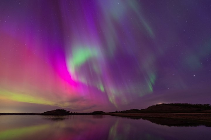
The Earth’s magnetic field directs the charged particles in the solar wind to the North and South Poles, and that is why the Aurora Borealis is sometimes called the Northern Lights. The Aurora Australis is sometimes called the Southern Lights south of the equator. Gas in the atmosphere absorbs the charged particles and radiates light, the color of the light is based on the type of gas. This is the same principle as an electrically powered neon sign where the color of the light is based on the type of gas contained in the glass tube. Nitrogen molecules produce red light, oxygen molecules produce green light, and so forth. If you have not seen the Aurora Borealis, you need to add it to your bucket list as it is spectacular.
In December 1995 the European Space Agency’s Solar and Heliospheric Observatory Satellite (SOHO) was launched and continues to give us clear images of this solar wind as it passes through the Sun’s corona. Similar to the moon during a total solar eclipse, it achieves this by using a disk to block the Sun’s bright disk, leaving just its corona. SOHO is in an orbit at a Lagrange point, where the gravitational pull from the Sun and Earth are equal, and thus can remain there without using much station keeping fuel. There are 12 instruments on board. One of the more interesting instruments is the Global Oscillation at Low Frequency (GOLF) instrument. It images the sound waves on the surface of the Sun like how a seismometer on Earth measures an earthquake. From that scientists are able to determine the Sun’s interior structure. To learn more about SOHO go to https://www.esa.int/esearch?q=SOHO.
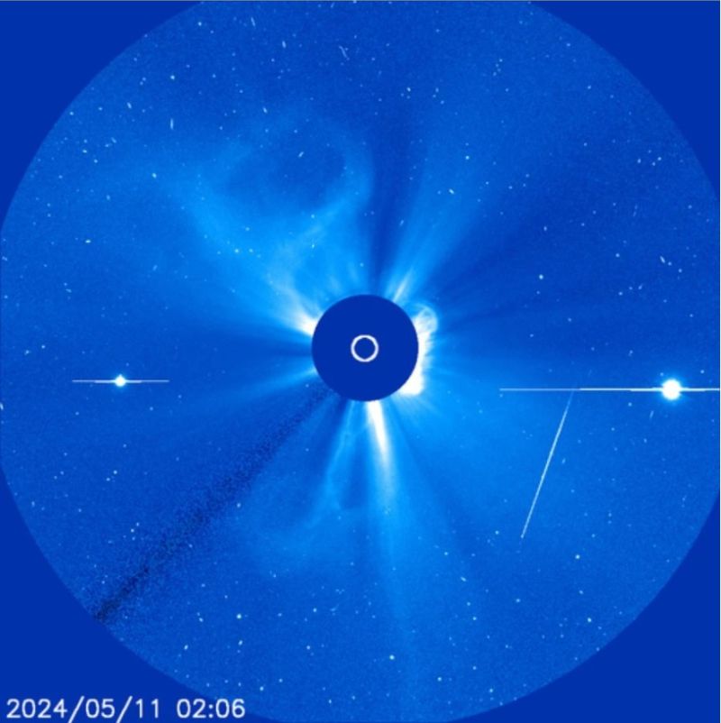
A NASA satellite that monitors the Sun is the Solar Dynamics Observatory (SDO) which launched in February 2010 and is in a geostationary orbit. It has three instruments: the helioseismic and magnetic imager, the atmospheric imaging assembly, and the extreme ultraviolet variability experiment, which built upon the work of SOHO. One of the more interesting instruments, the Atmospheric Imaging Assembly (AIA), comprises four telescopes which image the sun in 10 wavelengths each at 4K x 4K resolutions every 10 seconds. You can follow the SDO science at https://sdo.gsfc.nasa.gov/.
Launched in August 2018, the NASA Parker Solar Probe (PSP) is the first satellite to pass through the Sun’s corona in 2021 and is also the first NASA mission to be named after a living researcher, Eugene Parker. It was not known where the boundary of the outer most edge of the Sun’s corona, also known as the Alfven critical surface, was until PSP crossed it. The farthest point where solar material is still captured by the Sun’s gravity is the edge of the corona.
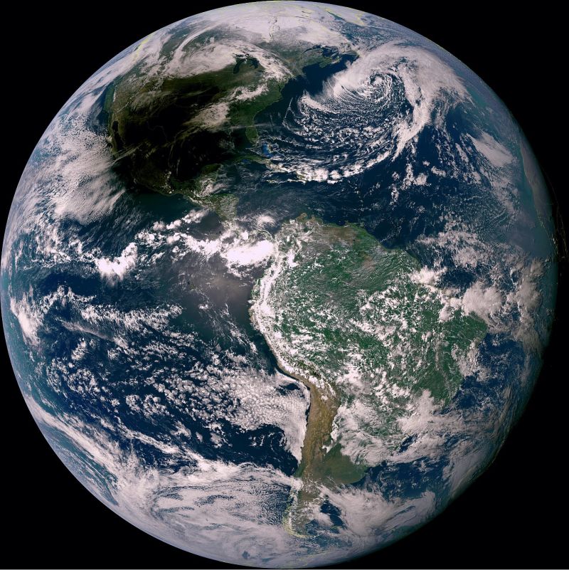
Another satellite that monitors the Sun, in addition to its primary role of monitoring the Earth’s weather, is the Geostationary Operation Environmental Satellite (GOES). GOES-16 stationed over the Atlantic. It carries an extreme ultraviolet telescope called the Solar Ultraviolet Imager (SUVI) which images the Sun in 6 different wavelengths. Nowhere near the resolution of SOHO, it is still a valuable tool and the images are part of the GOES ReBroadcast (GRB) data transmission. From May 10th 2024 through May 16th 2024, data from this author’s GOES ground station was received and animated. Animations of two of the six wavelengths can be downloaded this Dropbox link: https://www.dropbox.com/scl/fo/e4m0k2hftkcg80oozzbeo/AJEefeQ8alUvCqqr5QBtPv4?rlkey=kk9m1nyxfvv3ul9i78j283a2n&st=u86chz4n&dl=0. For more about the SUVI see https://www.swpc.noaa.gov/products/goes-solar-ultraviolet-imager-suvi . Also monitoring space weather on the GOES are the Extreme Ultraviolet and X-ray Irradiance Sensors and the Space Environment In-Situ Suite. Although the primary use of GOES is to monitor the Earth’s weather, this author used it for a different purpose. Since this author could not travel to see the total solar eclipse, he did the next best thing: to watch the moon’s shadow cross over the Earth from the GOES point-of-view. The Dropbox link above contains an animation of the eclipse from GOES.
For more information about solar flares, check out https://science.nasa.gov/science-research/heliophysics/how-nasa-tracked-the-most-intense-solar-storm-in-decades/ and https://www.youtube.com/watch?v=j59pEqkPkLE&list=WL&index=50.
Until next time, enjoy your summer. Ed.

[ Back to Top ]


From NOAA's National Environmental Satellite, Data, and Information Service
https://www.nesdis.noaa.gov/news-events/noaas-goes-u
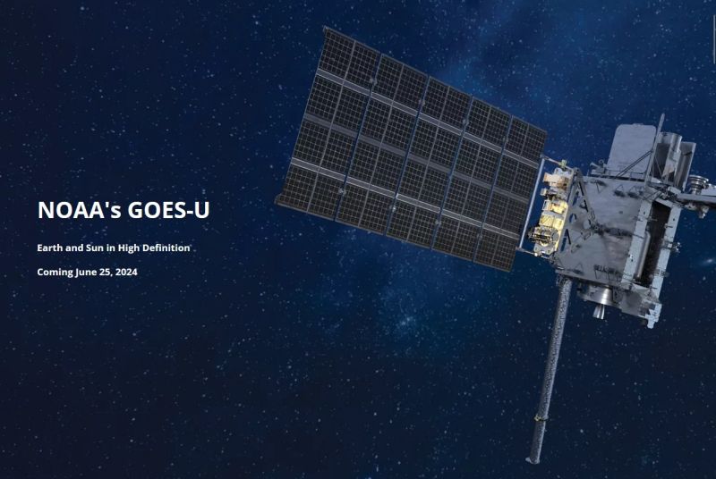
NOAA's GOES-U is set for launch on June 25, 2024 from Kennedy Space Center, Florida. NOAA’s GOES-U is the fourth and final satellite in the Geostationary Operational Environmental Satellites (GOES) – R Series, the Western Hemisphere’s most sophisticated weather-observing and environmental monitoring system. The GOES-R Series provides advanced imagery and atmospheric measurements, real-time mapping of lightning activity, and space weather observations.
Following a successful on-orbit checkout of its instruments and systems, NOAA plans to put GOES-19 into operational service. GOES-19 will be positioned to monitor weather systems and environmental hazards affecting most of North America, including the continental United States and Mexico, as well as Central and South America, the Caribbean, and the Atlantic Ocean to the west coast of Africa. In this position, the satellite will be known as "GOES East."
GOES-19 will work in tandem with GOES-18, which serves as "GOES West.” Together, these satellites will watch over more than half the globe – from New Zealand to the west coast of Africa and from near the Arctic Circle to the Antarctic Circle. The current GOES East (GOES-16) will become an on-orbit backup.
GOES-19 will provide critical atmospheric, hydrologic, oceanic, climatic, solar and space data, for advanced detection and monitoring of environmental phenomena that directly affect public safety, protection of property, and our nation’s economic health and prosperity, including:
Visit https://www.nesdis.noaa.gov/news-events/noaas-goes-u for more information, videos, and lots of links to more GOES-U resources and what comes next -- GeoXo!

[ Back to Top ]
From NASA Jet Propulsion Laboratory
at https://www.nasa.gov/missions/prefire/twin-nasa-satellites-ready-to-help-gauge-earths-energy-balance/
May 30, 2024
Information from the PREFIRE mission will illuminate how clouds and water vapor in the Arctic and Antarctic influence the amount of heat the poles radiate into space.
A pair of new shoebox-size NASA satellites will help unravel an atmospheric mystery that’s bedeviled scientists for years: how the behavior of clouds and water vapor at Earth’s polar regions affects our planet’s climate.
The first CubeSat in NASA’s Polar Radiant Energy in the Far-InfraRed Experiment (PREFIRE) mission launched from New Zealand on Saturday, May 25. The second PREFIRE CubeSat is targeted to lift off on Saturday, June 1, with a launch window opening at 3 p.m. NZST (11 p.m. EDT, Friday, May 31).
The mission will measure the amount of heat Earth emits into space from the two coldest, most remote regions on the planet. Data from PREFIRE will improve computer models that researchers use to predict how Earth’s ice, seas, and weather will change in a warming world.

[ Back to Top ]
By Tara Friesen, NASA
at https://www.nasa.gov/directorates/stmd/swarming-for-success-starling-completes-primary-mission/
May 29, 2024
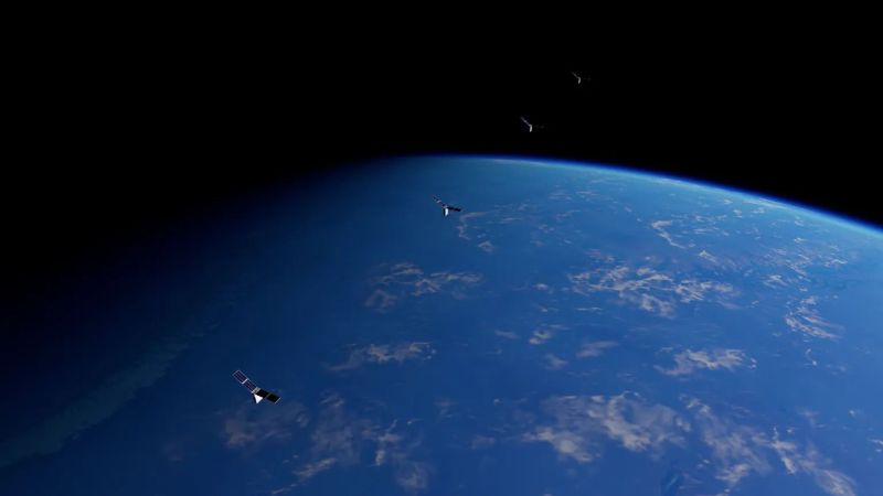
After ten months in orbit, the Starling spacecraft swarm successfully demonstrated its primary mission’s key objectives, representing significant achievements in the capability of swarm configurations.
Swarms of satellites may one day be used in deep space exploration. An autonomous network of spacecraft could self-navigate, manage scientific experiments, and execute maneuvers to respond to environmental changes without the burden of significant communications delays between the swarm and Earth.
"The success of Starling’s initial mission represents a landmark achievement in the development of autonomous networks of small spacecraft," said Roger Hunter, program manager for NASA's Small Spacecraft Technology program at NASA's Ames Research Center in California’s Silicon Valley. "The team has been very successful in achieving our objectives and adapting in the face of challenges."

[ Back to Top ]


By Erica McNamee, NASA
May 31, 2024
https://www.nasa.gov/earth/nasa-mission-flies-over-arctic-to-study-sea-ice-melt-causes/
It’s not just rising air and water temperatures influencing the decades-long decline of Arctic sea ice. Clouds, aerosols, even the bumps and dips on the ice itself can play a role. To explore how these factors interact and impact sea ice melting, NASA is flying two aircraft equipped with scientific instruments over the Arctic Ocean north of Greenland this summer. The first flights of the field campaign, called ARCSIX (Arctic Radiation Cloud Aerosol Surface Interaction Experiment), successfully began taking measurements on May 28.
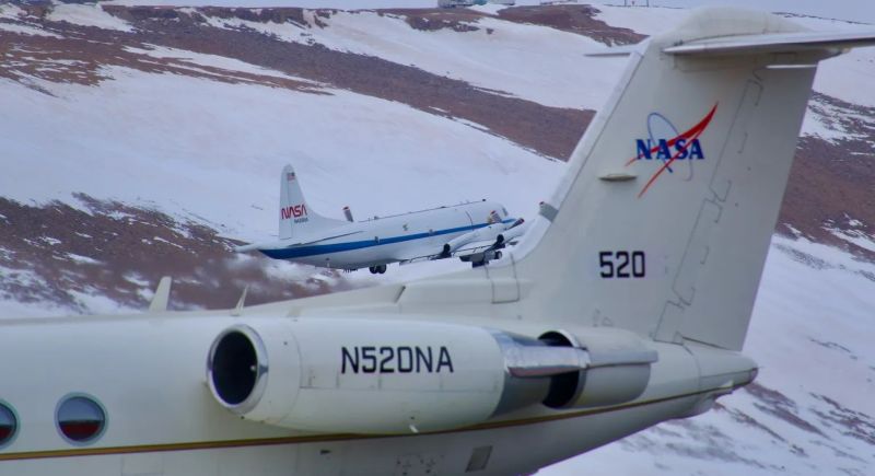
"The ARCSIX mission aims to measure the evolution of the sea ice pack over the course of an entire summer," said Patrick Taylor, deputy science lead with the campaign from NASA’s Langley Research Center in Hampton, Virginia. "There are many different factors that influence the sea ice. We're measuring them to determine which were most important to melting ice this summer."

[ Back to Top ]
From NOAA's National Environmental Satellite, Data, and Information Service
May 24, 2024
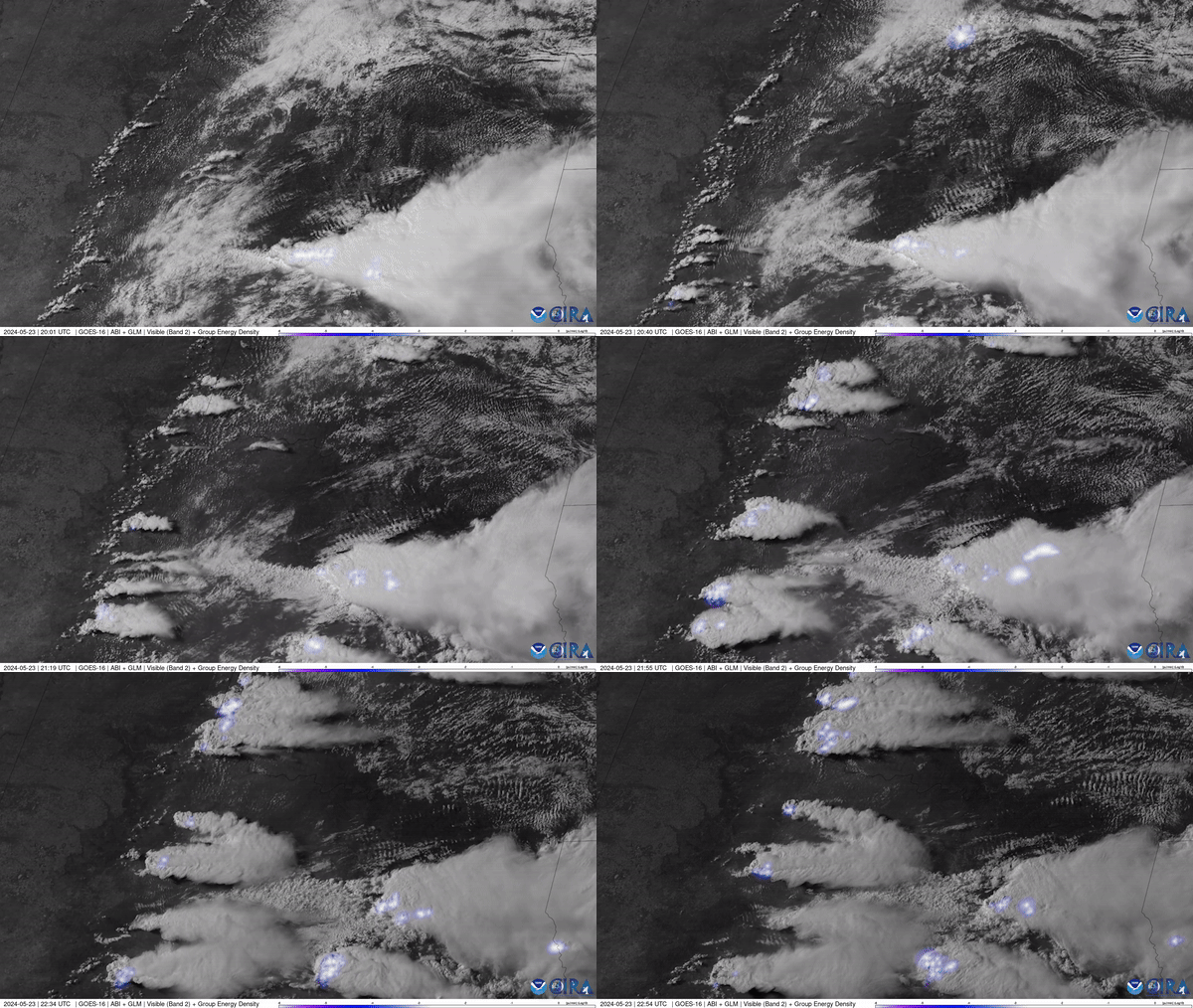
Phenomena: Severe Thunderstorms
Satellite: GOES-16
Product: Visible (Band 2), GLM Group Energy Density
Instrument: ABI, Geostationary Lightning Mapper
Date: May 23, 2024 (20:00 UTC) - May 23, 2024 (22:54 UTC)
NOAA’s GOES East (GOES-16) satellite watched severe thunderstorms fire up along a dry line situated in west Texas and western Oklahoma on May 23, 2024.
For a week, the central U.S. has been under a constant barrage of potent, sometimes deadly storms. Tornadoes swept across six states, killing at least five people in Iowa, injuring dozens of others and inflicting widespread damage that is estimated in the tens of millions of dollars. On Wednesday, tornadoes hit parts of central Texas, destroying homes and triggering rescue operations.
The GOES East geostationary satellite, also known as GOES-16, keeps watch over most of North America, including the contiguous United States and Mexico, as well as Central and South America, the Caribbean, and the Atlantic Ocean to the west coast of Africa. The satellite's high-resolution imagery provides optimal viewing of severe weather events, including thunderstorms, tropical storms, and hurricanes.
See the original article with additional resource links at https://www.nesdis.noaa.gov/news/severe-thunderstorms-fire-along-dry-line.

[ Back to Top ]
The Satellite Educators Association offers easy access to, and guides for using, decades of satellite-based remote sensing data primarily from NOAA, NASA, and USGS. The offering comes in two parts:
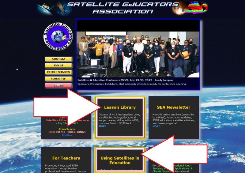
This comprehensive section of SEA Web site has five sequential parts:
The SEA Lesson Plan Library houses 40 lesson modules for grades K-12, all based on the Next Generation Science Standards. Each lesson plan has two parts: Teaching Notes and Student Activity pages. Both parts are downloadable in PDF. The Student Activity pages are also available in DOCX allowing the teacher to more easily adapt the lesson materials to the specific needs of the students, the curriculum and classroom situation. All lesson plans follow the same format as described on Library's front page. The front page also includes an explanation of the Next Generation Science Standards (NGSS) and the National Science Education Standards.
The Library offers three methods of searching for lesson plans:
Saving the best for last...Perhaps the most important fact to know about More Lessons From the Sky is this library is curated. That means that each and every lesson module is periodically reviewed to revise and update content, resources, and all listed resource links. The update usually occurs during the mid-year months. The date of the most recent update is listed on the inside of the lesson plan title page. The 2024 review and update is already under way.
During a break between semesters is a perfect time for teachers to explore the SEA Lesson Plan Library to select and experience the lessons for themselves in preparation for using them with students.

[ Back to Top ]


From NOAA News & Features
at https://www.noaa.gov/news/us-struck-with-more-than-100-tornadoes-heavy-snow-in-april
May 8, 2024
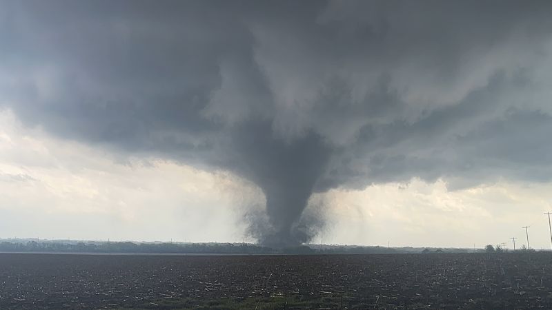
April continued the year’s warm streak, with 2024 ranking as the fifth-warmest year on record for the nation so far.
The month also saw a lot of active weather, with more than one hundred tornadoes and a powerful winter storm hitting parts of the U.S., according to scientists from NOAA’s National Centers for Environmental Information.
Below are more takeaways from NOAA’s latest monthly U.S. climate report:
The average April temperature across the contiguous U.S. was 53.8 degrees F (2.7 degrees above the 20th-century average), ranking as 12th-warmest in NOAA’s 130-year climate record. Virginia and West Virginia had their fifth-warmest Aprils on record while Kentucky, Maryland and Ohio each saw their top-10 warmest Aprils on record.
The average precipitation for the month was 2.77 inches — 0.25 of an inch above average, which places the month in the wettest third of the historical record. Indiana and Pennsylvania had their fifth-wettest April on record, with South Dakota seeing a top-10 wettest April.
See also April 2024 was Earth's Warmest on Record in NOAA News & Features.

[ Back to Top ]
By Laura Castro and Amy Butler, NOAA Climate.gov
at https://www.climate.gov/news-features/blogs/polar-vortex/and-thats-wrap-seasons-stratospheric-polar-vortex
May 2, 2024
As polar vortex season winds down, so does Season 1 of the Polar Vortex Blog. In our final post of the season, we discuss whether the season is ending on a cliffhanger or just tying up loose ends.
The polar stratospheric west-to-east winds have been steadily weakening and as of April 28, the winds at 60 degrees North, 10-hPa reversed direction, becoming east-to-west. As mentioned in the previous post, this breakdown of the polar vortex isn’t a shocking cliffhanger, but rather the final stratospheric warming that occurs every spring as a result of the sun "rising" over the North Pole. Probably the most noteworthy part of the final warming is that it happened later than normal (on average, it’s April 12). But this was expected because the final warming sometimes occurs later if a major warming event occurs in March.
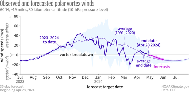
Find out more about the polar vortex at NOAA Climate.gov's Welcome to the Polar Vortex Blog!.

[ Back to Top ]
From NASA Jet Propulsion Laboratory, California Institute of Technology
at https://www.jpl.nasa.gov/news/nasas-juno-provides-high-definition-views-of-europas-icy-shell
May 15, 2024
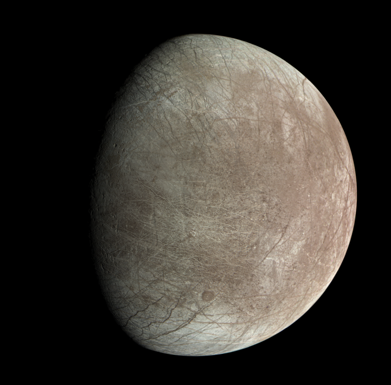
Images from the JunoCam visible-light camera aboard NASA’s Juno spacecraft supports the theory that the icy crust at the north and south poles of Jupiter’s moon Europa is not where it used to be. Another high-resolution picture of the icy moon, by the spacecraft’s Stellar Reference Unit (SRU), reveals signs of possible plume activity and an area of ice shell disruption where brine may have recently bubbled to the surface.
The JunoCam results recently appeared in the Planetary Science Journal and the SRU results in the journal JGR Planets.
On Sept. 29, 2022, Juno made its closest flyby of Europa, coming within 220 miles (355 kilometers) of the moon’s frozen surface. The four pictures taken by JunoCam and one by the SRU are the first high-resolution images of Europa since Galileo’s last flyby in 2000.
Juno’s ground track over Europa allowed imaging near the moon’s equator. When analyzing the data, the JunoCam team found that along with the expected ice blocks, walls, scarps, ridges, and troughs, the camera also captured irregularly distributed steep-walled depressions 12 to 31 miles (20 to 50 kilometers) wide. They resemble large ovoid pits previously found in imagery from other locations of Europa.

[ Back to Top ]


By Elizabeth E. Keller, NASA
at https://www.nasa.gov/general/spaceflight-affects-tumor-bearing-fruit-fly-hosts-and-their-parasites/
May 29, 2024

Background: Like humans, fruit flies (a model organism for spaceflight research) also exhibit immune system dysfunction in space. Despite decades of studies on fruit flies and wasps, little was known about how their immune systems interact with natural parasites in space. Drosophila parasitoid wasps modify blood cell function to suppress host immunity. In this spaceflight study (the Fruit Fly-03 Lab flown to the ISS on SpaceX-14), naive and parasitized ground and space flies from a tumor-free control and a blood tumor-bearing mutant strain were examined.
Main Findings: Surprisingly, the flies without tumors were more sensitive to space than the flies with tumors. Spaceflight increased immune gene activity and made tumors grow more in the flies. The wasps remained harmful in space, but some developed inheritable physical changes. These changes included “aurum” (altered wing color and veins) and “kona” (altered wing shape). Female wasps with two copies of the “kona” mutation could not lay eggs because of defective egg-laying organs.

[ Back to Top ]
From NOAA News & Features
at https://www.noaa.gov/stories/top-3-cop28-takeaways-for-resilient-sustainable-future
December 23, 2023
The 28th Conference of the Parties (COP28) has come to a dramatic end, with representatives from nearly 200 countries achieving a groundbreaking climate agreement, signaling a historic transition away from the use of fossil fuels in the energy sector. This unprecedented deal emerged after two weeks of intense negotiations.
The agreement is the first global climate pact that explicitly mentions a transition away from fossil fuel usage, targeting the major contributors to climate change. NOAA has emerged from the meeting with a renewed determination for the agency’s continued work to combat climate change and address its impacts.
In addition to the groundbreaking climate agreement, the following are 3 key takeaways from this global initiative to address the climate crisis:
COP28 underscores the vital role of science in shaping climate policies. NOAA's invaluable contributions - on topics ranging from ocean acidification to marine protected areas and conservation to marine carbon dioxide removal - were acknowledged by the worldwide community, with an emphasis on collaborating on a global scale for a secure, sustainable future.
Recognizing the urgency to take action in the face of the climate crisis, NOAA, alongside the White House Council on Environmental Quality, facilitated direct conversations between global youth leaders and U.S. officials at COP28.
The goal? To amplify the youth perspective and include future generations in contributing to climate solutions.
Teaming up with the International Trade Administration, NOAA highlighted the essential need for a resilient Blue Economy. By leveraging climate and ocean data (including from private sources), communities, industries and organizations can make informed decisions, foster sustainability and aid vulnerable coastal areas in adapting to climate impacts.
From protecting the ocean to championing innovative technologies and supporting youth-led initiatives, these and many other achievements mark a positive step forward in the collective effort to combat climate change. The path ahead may be challenging, but with collaborative initiatives like these, there is hope for a brighter and more sustainable future.
Learn more about NOAA’s work on climate change at climate.gov. See the original article with additional resource links at https://www.noaa.gov/stories/top-3-cop28-takeaways-for-resilient-sustainable-future

[ Back to Top ]
From NOAA News & Features
at https://www.noaa.gov/news/nothing-to-sneeze-at-new-research-shows-pollen-can-change-weather
May 9, 2024
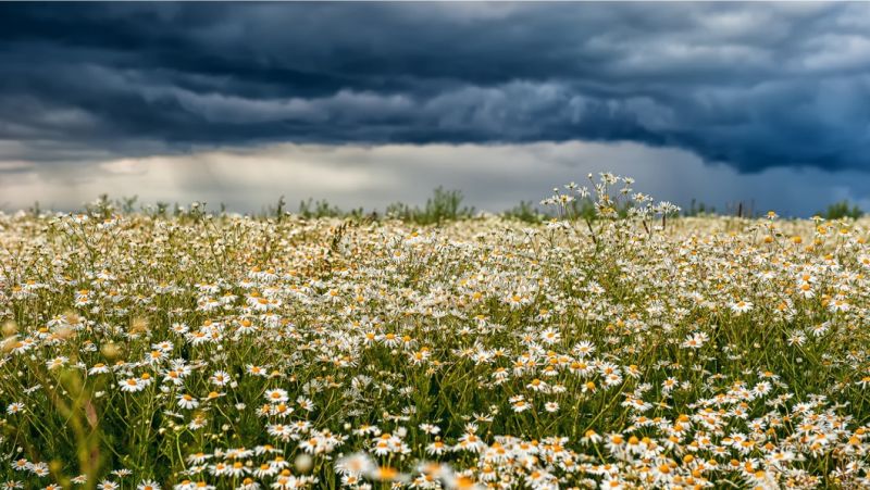
More than 80 million Americans suffer from seasonal allergies due to airborne pollen, according to the U.S. Centers for Disease Control and Prevention (CDC). Associated medical costs exceed $3 billion every year, with nearly half of those costs linked to prescription medicine.
Pollen is an equal opportunity irritant, particularly during spring, summer and fall when wind-blown pollen from trees, grasses and weeds can be at their highest levels. Accurate pollen forecasts could help sufferers reduce their exposure the same way that they might on high ozone days.
"With real-time predictions of pollen and where it is transported, people can adjust their outdoor activities, medications and take precautions to ensure their well-being."
Jordan Schnell, CIRES scientist working at NOAA's Global Systems Laboratory
For the past two years, researchers from NOAA’s Global Systems Laboratory (GSL) have been developing the first pollen forecast of its kind in the U.S. The forecast can predict both the impact of weather on pollen concentrations, and how pollen loads will influence the weather.
The experimental model has been generating pollen forecasts since the summer of 2022, and performs similarly to commercial pollen forecasts.
"Pollen and its associated allergies are important components to people’s everyday lives," said researcher Jordan Schnell, a CIRES scientist working at GSL. "With real-time predictions of pollen and where it is transported, people can adjust their outdoor activities, medications and take precautions to ensure their well-being."

[ Back to Top ]


A reflection by SEA staff writer
The first half of this year, 2024, has seen a remarkable number of tornadoes sweep through the United States, as many as 100 during April 2024. A tornado can form where cold dry air meets warm moist air. Of all places on the globe, this condition is met most easily in the Great Plains region of the United States. Here, the jet stream brings cold dry air south from Canada to meet warm moist air moving north from the Gulf of Mexico. This "tornado alley" has been expanding to include more states to the east of the Great Plains.
Is it unusual to experience so many tornadoes, or other natural disasters, in such a short time? A quick look back reveals some interesting numbers.
The National Weather Service lists a Summary of 1999 Weather Events, Fatalities, Injuries, and Damage Costs in the 50 US states, Puerto Rico, Guam and the Virgin Islands. Included in the list are these statistics for the year:
Called the Super Outbreak in April 1974, there were 148 tornadoes in one day.

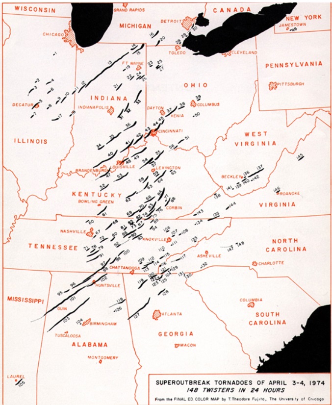
See also the Smithsonian's How 148 Tornadoes in One Day in 1974 Changed Emergency Preparedness.
Is 100 tornadoes in one month unusual? Check out the resources above and judge for yourself.

[ Back to Top ]


From NOAA
at https://www.noaa.gov/education/young-changemakers-fellowship/news/application-for-noaas-young-changemakers-fellowship-is-now-open
May 15, 2024
The Young Changemakers Fellowship is a year-long empowerment program for high school students. Fellows receive mentorship, skill-building opportunities, and support from NOAA to design and lead an action project in their own community. They also learn about how NOAA works and directly provide their perspectives on agency priorities to NOAA’s leadership team.
"The Young Changemakers Fellowship is a fantastic and unique opportunity, both for the student participants and for the agency," says NOAA Administrator Rick Spinrad, Ph.D. "I look forward to learning from the perspectives of this upcoming cohort of changemakers."
The program runs from July 2024 through June 2025. Fellowship benefits include an expenses-paid kick-off summit in Washington, D.C., a $800 participation stipend, and up to $750 of action project funding.
The fellowship is open to young people ages 13 and older who will be in high school during the 2024-2025 school year. Students living and attending school across the United States, U.S. territories, and tribal nations are encouraged to apply. The program welcomes students with a wide variety of interests, as well — aspiring artists, communicators, tech innovators, and educators are just as appreciated as budding scientists and future policy makers.
"We encourage all interested high school students to apply, even if they don’t view themselves as changemakers quite yet," says Lauren Gibson, Ph.D., who manages the fellowship. "This program is all about learning and growth — both for the students and for our agency."
The application launch for the upcoming cohort of changemakers comes on the heels of a successful pilot year. During the 2023-2024 school year, nine students were nominated to pilot the Young Changemakers Fellowship through the eeBLUE partnership, a five-year agreement between the North American Association for Environmental Education (NAAEE) and NOAA's Office of Education that aims to increase environmental and scientific literacy. This year, NOAA will select up to 15 program participants via a competitive application process.
For more information on the program and how to apply, please visit the Young Changemakers Fellowship website. Applications are due on June 10, 2024.>
See the original story at https://www.noaa.gov/education/young-changemakers-fellowship/news/application-for-noaas-young-changemakers-fellowship-is-now-open.

[ Back to Top ]
As a classroom teacher for nearly four decades, I can attest to the fact that every veteran teacher remembers individual students who impacted their lives with specific accomplishments, growth, insights, and character. I was especially moved by the following story which I commend to your consideration. It is hoped that every teacher reading Dr. Day's account of his encounter with this special young gentleman will take heart in the possible and the future of each of their students.
-Pete Arvedson, Editor
From NASA Science Editorial Team
at https://science.nasa.gov/get-involved/citizen-science/the-moon-and-amaey-shah/
May 30, 2024
Sometimes a story about a NASA volunteer just grabs your heart and won't let go. NASA Scientist Dr. Brian Day shared with us the incredible story of what first ignited his passion for involving the public in his scientific research. It’s a story about a boy named Amaey Shah.

"Through the NASA Speakers Bureau, I was paired with a local teacher, Leslie Herleikson, and her after-school science program for K-12 students" Brian began. "I’d talk to the students in the program periodically and take them on tours of the NASA Ames facilities."
"One of the kids in Leslie’s elementary program, a young boy named Amaey Shah, was recovering from treatment for childhood leukemia when I first met him. He was feeling fatigued from the treatment. As we did the tours of Ames he sometimes had to rest. But he was a very precocious kid. He remained very excited about science, posing a rapid stream of very insightful questions, and always full of joyous enthusiasm for the new things that he would learn.
Over time, Amaey rallied and his strength improved, fueled by his insatiable curiosity. I continued to meet with Amaey and his fellow students, with our discussions spanning the Solar System and beyond.
Then, one day, I showed up at the after-school program and Amaey was not there. Leslie took me aside after my presentation and let me know that Amaey had had a relapse which seemed pretty serious. He was going to need a bone marrow transplant. This news hit me especially hard. Shortly before the class meeting, I had been diagnosed with cancer myself. Just as Amaey was going to be heading in for whole body radiation as part of his bone marrow transplant, I was going to be going in for radiation for my own cancer treatment.

[ Back to Top ]


Tornadoes can happen anytime, anyplace under the right conditions, but the United States is more prone to tornadoes than anywhere else in the world. There is even an area of the United States called 'tornado alley' In this lesson, you will have an opportunity to discover where and how to access information about tornadoes, produce a map of where they occur, study images of tornadoes from ground and space, communicate a theory about how they form, determine how the frequency and intensity of tornadoes has changed over time, and become familiar with what to do before, during and after a tornado strike.
| Grade Level: | 5-12 |
| Time Requirement: | 2-3 class periods |
| Prerequisites: | None |
| Relevant Disciplines: | Earth& Space Science, Geography, Physical Science |

[ Back to Top ]
Share your satellite-based lesson ideas with the teaching community.
Send us a full lesson plan, or simply suggest a lesson idea. If you found the idea online, please share the source as well. The lesson can be about anything that helps connect learners with satellite-based technology - any grade level K-12 - any STEM subject area or geography.
"Satellite-technology" includes any part of the science, math, engineering, or technology of satellites, rockets, and remote sensing instruments as well as the use of any environmental satellite data to explore questions related to aspects of global change and local impacts in the long term, short term, and catastrophic time frames. Of special interest are lessons providing opportunities for learners to inquire, experiment, and apply mathematics.
Perhaps you designed a lesson yourself - we will happily prepare it for future publication in More Lessons from the Sky and inclusion in the SEA Lesson Plan Library. Perhaps you found a worthy lesson plan published elsewhere - we can research it inclusion in a lesson plan spotlight. In either case, you will receive full credit for developing and/or bringing the lesson to the attention of the teaching community. Don't forget to share your insights if you tried the lesson with students.
Please share your ideas at SEA.Newsletter@SatEd.org.
[ Back to Top ]